List of county routes in Niagara County, New York (26–50)
|
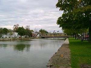
The bridge carrying NY 271 over the Erie Canal in Middleport. CR 45, a county-maintained part of the route, begins on the north side of the bridge (shown at left). | |
| Highway names | |
|---|---|
| Interstates: | Interstate X (I-X) |
| US Highways: | U.S. Route X (US X) |
| State: | New York State Route X (NY X) |
| County: | County Route X (CR X) |
| System links | |
County routes in Niagara County, New York, are not signed and there is no apparent numbering pattern. Most of the county routes act as primary roads in the less developed areas and also serve to interconnect the various villages and hamlets of Niagara County. Niagara County maintains few county routes, including only the most important connecting thoroughfares, and those are maintained by the Niagara County highway department. Most of the roads in the county, including many of the local through highways, are maintained by the towns. Routes 26 through 50 are listed below.
County Route 26
| County Route 26 | |
|---|---|
| Location: | Hartland |
| Length: | 2.09 mi[1] (3.36 km) |
County Route 26 is the designation for a 2.09-mile (3.36 km) county-maintained section of NY 271 between the Middleport north village line and NY 271's north end at NY 104 (Ridge Road) in the town of Hartland. The highway, named Stone Road, serves as a continuation of CR 45 (North Main Street), the number assigned to a county-maintained section of NY 271 within the village.
- Major intersections
The entire route is in Hartland, Niagara County.
| mi[1] | km | Destinations | Notes | ||
|---|---|---|---|---|---|
| 0.00 | 0.00 | North Main Street (CR 45) | Continuation into Middleport | ||
| 2.09 | 3.36 | ||||
| 1.000 mi = 1.609 km; 1.000 km = 0.621 mi | |||||
County Route 31
| County Route 31 | |
|---|---|
| Location: | Lockport |
| Length: | 2.08 mi[1] (3.35 km) |
County Route 31, named Old Niagara Road, is an east–west route just north of the city of Lockport. CR 31 begins at an intersection with CR 19 (Stone Road) and CR 23 (Plank Road) at the Lockport city line. From there CR 31 heads east along the northern edge of the city, intersecting NY 78 (Lake Avenue) at 1.69 miles. Not long after, CR 31 reaches CR 77 (North Canal Road) just short of the Erie Canal, where the designation has its east end.
The roadway that continues east over the Erie Canal is Cold Springs Road and travels 0.65 miles to end at NY 31 (Chestnut Ridge Road).
- Major intersections
The entire route is in Lockport, Niagara County.
| mi[1] | km | Destinations | Notes | ||
|---|---|---|---|---|---|
| 0.00 | 0.00 | Stone Road (CR 19) / Plank Road (CR 23) | Lockport city line | ||
| 1.69 | 2.72 | ||||
| 2.08 | 3.35 | North Canal Road (CR 77) | |||
| 1.000 mi = 1.609 km; 1.000 km = 0.621 mi | |||||
County Route 32
| County Route 32 | |
|---|---|
| Location: | Wheatfield–Pendleton |
| Length: | 4.50 mi[1] (7.24 km) |
County Route 32 is a well-traveled east–west county route in the towns of Wheatfield and Pendleton named Mapleton Road. CR 32 begins at CR 6 (Lockport Road), where CR 6 turns to run northeast while CR 32 continues due east. CR 32 intersects NY 425 (Shawnee Road) at 0.74 miles and shortly after crosses into the town of Pendelton. CR 32 passes by the Starpoint Central School District which lie on the north side of the road between Townline and Aiken roads. At 4.0 miles, CR 32 intersects the northern end of Main Road, a heavily traveled cut through for people traveling south to NY 270. Not long after Main, CR 32 reaches its east end at NY 270 (Campbell Boulevard).
Mapleton Road itself continues due east with no county route designation to CR 96 (Bear Ridge Road) on the bank of the Erie Canal where the road ends.
- Major intersections
| Location | mi[1] | km | Destinations | Notes | |
|---|---|---|---|---|---|
| Wheatfield | 0.00 | 0.00 | Lockport Road (CR 6) | ||
| 0.74 | 1.19 | ||||
| Pendleton | 4.00 | 6.44 | Main Road | ||
| 4.50 | 7.24 | ||||
| 1.000 mi = 1.609 km; 1.000 km = 0.621 mi | |||||
County Route 35
| County Route 35 | |
|---|---|
| Location: | Royalton |
| Length: | 3.56 mi[1] (5.73 km) |
County Route 35 is a north–south county route in the town of Royalton named Riddle Road. CR 35 runs along the western edge of the town and travels from CR 58 (Tonawanda Creek Road North) in the south to NY 93 (Dysinger Road) in the north. It intersects only local roadways along its length of 3.56 miles (5.73 km).
- Major intersections
The entire route is in Royalton, Niagara County.
| mi[1] | km | Destinations | Notes | ||
|---|---|---|---|---|---|
| 0.00 | 0.00 | Tonawanda Creek Road North (CR 58) | |||
| 3.56 | 5.73 | ||||
| 1.000 mi = 1.609 km; 1.000 km = 0.621 mi | |||||
County Route 36
| County Route 36 | |
|---|---|
| Location: | Porter–Wilson |
| Length: | 9.71 mi[1] (15.63 km) |
County Route 36 is an east–west (southwest–northeast) county route in the towns of Porter and Wilson named Youngstown Road or Youngstown–Wilson Road. CR 36 begins at NY 93 (Youngstown–Lockport Road) and heads north, curving east just south of the Niagara Frontier Country Club. The roadway heads due east until the road splits at a Y-intersection with Bradley Road. From here CR 36 maintains a general east-northeast direction for the remainder of its routing. Well traveled Ransomville Road (CR 17) is intersected as well as many other local roadways. After CR 36 enters the town of Wilson, and nears the village of Wilson, CR 78 (West Lake Road) is intersected which travels west a very short distance to NY 18. At 9.71 miles, CR 36 reaches the Wilson village line where the road changes names and designation, becoming Young Street and assuming the CR 126 designation.
- Major intersections
| Location | mi[1] | km | Destinations | Notes | |
|---|---|---|---|---|---|
| Porter | 0.00 | 0.00 | |||
| 5.51 | 8.87 | Ransomville Road (CR 17) | |||
| Town of Wilson | 9.64 | 15.51 | West Lake Road (CR 78) | ||
| 9.71 | 15.63 | Young Street (CR 126) | Continuation into the village of Wilson | ||
| 1.000 mi = 1.609 km; 1.000 km = 0.621 mi | |||||
County Route 40
| County Route 40 | |
|---|---|
| Location: | Pendleton |
| Length: | 3.33 mi[1] (5.36 km) |
County Route 40 is an east–west route located in the town of Pendleton and is named Beach Ridge Road. CR 40 begins at CR 20 (Townline Road) and from there heads in a general northeast direction atop a local ridge. CR 40 intersects only two roads along its routing, Aiken and Meyer Roads. Before reaching its end, Route 40 turns to head due east and ends at the intersection of NY 270 (Campbell Boulevard), CR 121 (Feigle Road) and Main Road in the hamlet of Pendleton Center.
- Major intersections
| Location | mi[1] | km | Destinations | Notes | |
|---|---|---|---|---|---|
| Wheatfield–Pendleton town line | 0.00 | 0.00 | Townline Road (CR 20) | ||
| Pendleton | 3.33 | 5.36 | |||
| 1.000 mi = 1.609 km; 1.000 km = 0.621 mi | |||||
County Route 44
| County Route 44 | |
|---|---|
| Location: | Cambria |
| Length: | 0.82 mi[1] (1.32 km) |
County Route 44 is a short north–south county route named Comstock Road and is located in the town of Cambria. CR 44 begins at CR 6 (Lockport Road) and heads north only 0.82 miles, passing farms and houses until it reaches NY 31 (Saunders Settlement Road), where the county route designation ends.
Comstock Road itself continues north of NY 31 for another 1.32 miles to CR 5 (Upper Mountain Road).
- Major intersections
The entire route is in Cambria, Niagara County.
| mi[1] | km | Destinations | Notes | ||
|---|---|---|---|---|---|
| 0.00 | 0.00 | Lockport Road (CR 6) | |||
| 0.82 | 1.32 | ||||
| 1.000 mi = 1.609 km; 1.000 km = 0.621 mi | |||||
County Route 45
| County Route 45 | |
|---|---|
| Location: | Middleport |
| Length: | 0.59 mi[1] (0.95 km) |
County Route 45 is the designation for a county-maintained section of NY 271 in the village of Middleport. The route begins on the north side of the Erie Canal at the junction of North Main Street (NY 271) and Mill Street and heads north along North Main Street for just over a half a mile to the northern village line, where CR 45 ends and NY 271 continues into the town of Hartford as Stone Road. The segment of NY 271 north of the village is also county-maintained as CR 26.
- Major intersections
The entire route is in Middleport, Niagara County.
| mi[1] | km | Destinations | Notes | ||
|---|---|---|---|---|---|
| 0.00 | 0.00 | Mill Street | |||
| 0.59 | 0.95 | Stone Road (CR 26) | Continuation into Hartland | ||
| 1.000 mi = 1.609 km; 1.000 km = 0.621 mi | |||||
See also
.svg.png) New York Roads portal
New York Roads portal