Corrigin, Western Australia
| Corrigin Western Australia | |||||||
|---|---|---|---|---|---|---|---|
 Statue of dog to commemorate world record 1,527 ute convoy 2003. | |||||||
 Corrigin | |||||||
| Coordinates | 32°20′S 117°53′E / 32.33°S 117.88°ECoordinates: 32°20′S 117°53′E / 32.33°S 117.88°E | ||||||
| Population | 903 (2006 census)[1] | ||||||
| Established | 1900s | ||||||
| Postcode(s) | 6375 | ||||||
| Elevation | 295 m (968 ft) | ||||||
| Location | 229 km (142 mi) from Perth | ||||||
| LGA(s) | Shire of Corrigin | ||||||
| Region | Wheatbelt | ||||||
| State electorate(s) | Wagin | ||||||
| Federal Division(s) | O'Connor | ||||||
| |||||||
Corrigin is a town in the central Wheatbelt region of Western Australia, 229 kilometres (142 mi) east-southeast of the state capital, Perth, Western Australia, along State Route 40. It is mostly a farming community focused on crops and sheep, and holds the world record of 'the most dogs in a ute'.[2]
History
The name "Corrigin", of Noongar indigenous origin, was first recorded in 1877 relating to a well in the area. The meaning of the name is unknown.
Before 1908 Corrigin's only connection with the rest of the state was the railway track that ran to Merredin and it was difficult to get anyone to take up land near the rabbit proof fence. Most of the land as once held by George Walton on a pastoral lease which he ran from his homestead at Wogerlin rock. The first settlers to the area were Mr A. W. Goyder (the son of the South Australian Surveyor General), who took up the area on which the town now stands. He was followed by Jack Crossland then by Messrs Gayfer and Jose Bros.[3]
In 1909, the Government planned to build a railway from Brookton[4] on the Great Southern Railway to the town of Kunjin, 17 km west of Corrigin. Some time after, a line from Wickepin was also proposed, and the Government decided to locate the crossing point at Corrigin.[5]
A storm swept through the area in 1913 lashing the area with hailstones over 1 inch (25 mm) in diameter. The town was also deluged with over 3.5 inches (89 mm) of rain in a few hours. Standing crops were flattened, fences in low-lying areas were washed away and most of the town was submerged under at least 2 feet (0.6 m) of water.[6]
In 1913, a railway siding was built, and named "Dondakin" by railway authorities due to conflict with the name elsewhere. However, after much local protest, the siding was renamed Corrigin and gazetted on 15 May 1914.[7] The railway line from Wickepin, Western Australia opened a month later, and the main office of the local Road Board moved to the town. In 1915, a school was built.
In 1932 the Wheat Pool of Western Australia announced that the town would have two grain elevators, each fitted with an engine, installed at the railway siding.[8] The bulk handling facility had been installed by November the following year and the first trial load of wheat was satisfactorily loaded.[9]
By 1937 the town boasted a hall that cost £8.000 to build, a large state hotel, commercial buildings, bowling green, tennis courst, golf course and one of the best showgrounds in the state. The town still had no adequate water scheme, there was no lack of well water but the water drawn was very hard.[3]
The wheatbelt was struck by drought for much of 1939 and nearly all of 1940, described at the time as the worst in the states history until heavy rains arrived in December of that year. Corrigin received 4.63 inches (118 mm) of drought-breaking rain over a couple of days.[10]
The town was lashed by a violent storm on New Year's Day in 2013. Destructive winds and 60 millimetres (2 in) of rain tore through over the course of an hour leaving behind fallen powerlines, uprooted trees, sheds torn apart and roofs ripped from homes.[11]
Present day
Corrigin has a population of 903 and is a key agricultural centre for a district focussed mainly on wheat and sheep farming. It is the location of a CBH management zone office,[12] and in 1973 was the location of a 'type B' wheat bin.
It contains a district high school (originally opened 1915 as a primary school), National Australia bank, shopping facilities, accommodation (hotel, motel, caravan park), council offices and a telecentre. Each year, it hosts an agricultural show.
The town is a stop on the Transwa bus service to Esperance via Kulin/Hyden.[13]
A large rocky outcrop just to the east of town is Corrigin Rock.
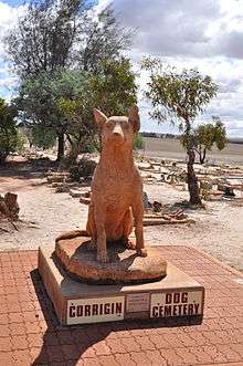
About 5 km west of town is the Corrigin dog cemetery, containing over 80 buried dogs.
Climate
| Climate data for Corrigin | |||||||||||||
|---|---|---|---|---|---|---|---|---|---|---|---|---|---|
| Month | Jan | Feb | Mar | Apr | May | Jun | Jul | Aug | Sep | Oct | Nov | Dec | Year |
| Record high °C (°F) | 44.9 (112.8) |
46.5 (115.7) |
42.8 (109) |
37.1 (98.8) |
33.3 (91.9) |
24.8 (76.6) |
23.5 (74.3) |
29.0 (84.2) |
33.1 (91.6) |
38.3 (100.9) |
41.7 (107.1) |
43.9 (111) |
46.5 (115.7) |
| Average high °C (°F) | 32.5 (90.5) |
31.5 (88.7) |
28.9 (84) |
24.3 (75.7) |
19.7 (67.5) |
16.4 (61.5) |
15.3 (59.5) |
16.4 (61.5) |
19.1 (66.4) |
23.1 (73.6) |
27.0 (80.6) |
30.4 (86.7) |
23.7 (74.7) |
| Average low °C (°F) | 15.8 (60.4) |
16.0 (60.8) |
14.3 (57.7) |
11.2 (52.2) |
7.6 (45.7) |
5.9 (42.6) |
4.9 (40.8) |
4.7 (40.5) |
5.7 (42.3) |
8.2 (46.8) |
11.3 (52.3) |
14.0 (57.2) |
10.0 (50) |
| Record low °C (°F) | 7.0 (44.6) |
6.5 (43.7) |
2.2 (36) |
−1.1 (30) |
−4.3 (24.3) |
−4.0 (24.8) |
−3.8 (25.2) |
−2.8 (27) |
−2.5 (27.5) |
−0.3 (31.5) |
−0.2 (31.6) |
3.9 (39) |
−4.3 (24.3) |
| Average precipitation mm (inches) | 16.9 (0.665) |
16.2 (0.638) |
21.0 (0.827) |
23.0 (0.906) |
47.2 (1.858) |
60.2 (2.37) |
59.9 (2.358) |
47.3 (1.862) |
30.0 (1.181) |
21.1 (0.831) |
16.5 (0.65) |
13.1 (0.516) |
372.5 (14.665) |
| Average precipitation days | 2.5 | 2.6 | 3.4 | 5.1 | 9.5 | 12.6 | 14.2 | 12.3 | 9.3 | 6.4 | 4.2 | 2.7 | 84.8 |
| Average relative humidity (%) | 27 | 30 | 33 | 42 | 51 | 60 | 61 | 56 | 49 | 36 | 30 | 27 | 42 |
| Source: [14] | |||||||||||||
References
- ↑ Australian Bureau of Statistics (25 October 2007). "Corrigin". 2006 Census QuickStats. Retrieved 13 July 2009.
- ↑ Shire of Corrigin (25 October 2005). "Dog In A Ute 2002". Archived from the original on 13 September 2009. Retrieved 2006-11-15.
- 1 2 "History of Corrigin". The West Australian. Perth: National Library of Australia. 8 November 1937. p. 11 \. Retrieved 31 March 2013.
- ↑ Cross Country to Corrigin Milne, Rod Australian Railway Historical Society Bulletin, April, 1988 pp80-86
- ↑ All Change at Corrigin Milne, Rod Australian Railway Historical Society Bulletin, March, 1996 pp67-75
- ↑ "The Corrigin Storm". Sunday Times. Perth: National Library of Australia. 7 December 1913. p. 2. Retrieved 31 March 2013.
- ↑ Western Australian Land Information Authority. "History of country town names – C". Retrieved 2007-03-25.
- ↑ "Country elevators". The West Australian. Perth: National Library of Australia. 6 July 1932. p. 10. Retrieved 6 April 2013.
- ↑ "Country news". The West Australian. Perth: National Library of Australia. 25 November 1933. p. 7. Retrieved 7 April 2013.
- ↑ "W.A. drought broken". The Argus. Melbourne: National Library of Australia. 4 December 1940. p. 16. Retrieved 31 March 2013.
- ↑ "Roofs ripped off by Corrigin New Year's Day storm". Australian Broadcasting Corporation. 2 January 2013. Retrieved 4 January 2013.
- ↑ Zone 7 in the Kwinana Port Zone
- ↑ GE2 timetable (1 November 2006). Retrieved on 25 March 2007.
- ↑ "Climate statistics for Corrigin". Bureau of Meteorology. Retrieved 12 July 2014.
External links
| Wikimedia Commons has media related to Corrigin, Western Australia. |
- Shire of Corrigin
- Dog in a Ute – includes photos of the town bike and history of the event.
- Corrigin dog cemetery