Conwy County Borough
| Conwy County Borough Bwrdeistref Sirol Conwy | |
|---|---|
| unitary authority area | |
 | |
| Admin HQ | Conwy |
| Largest town | Colwyn Bay |
| Government | |
| • Type |
Conwy County Borough Council http://www.conwy.gov.uk/ |
| • Control | TBA (council NOC) |
| • MPs | |
| • AMs |
|
| • MEPs | Wales |
| Area | |
| • Total | 1,130 km2 (440 sq mi) |
| Area rank | Ranked 6th |
| Population (2011) | |
| • Total | 115,200 |
| • Rank | Ranked 15th |
| • Density | 98/km2 (250/sq mi) |
| • Density rank | Ranked 16th |
| • Ethnicity | 98.2% White |
| Welsh language | |
| • Rank | Ranked 5th |
| • Any skills | 39.7% |
| Geocode |
00NE (ONS) W06000003 (GSS) |
| ISO 3166 code | GB-CWY |
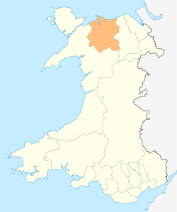
Conwy County Borough (Welsh: Bwrdeistref Sirol Conwy) is a unitary authority area in the north of Wales.
Geography
It contains the major settlements of Llandudno, Llandudno Junction, Llanrwst, Betws-y-Coed, Conwy, Colwyn Bay, Abergele, Penmaenmawr and Llanfairfechan, and has a total population of 115,000, the vast majority of which lives along the coast.
The River Conwy, after which the county borough is named, lies wholly within the area: rising in Snowdonia and flowing through Llanrwst and Trefriw en route to the Irish Sea by Conwy. The river here marks the border between the historic counties of Caernarfonshire and Denbighshire.
One third of the land area of the county borough lies in the Snowdonia national park, and the council appoint three of the 18 members of the Snowdonia National Park Authority. Its total area is 1,130 square km, making it slightly larger than Hong Kong.
Welsh language
According to the 2001 Census 39.7% of the population of the county borough have "one or more skills" in the Welsh language, which ranks it 5th out of 22 principal areas in Wales.[1]
The amount of Welsh spoken in the county borough greatly varies from location to location, with generally the least being spoken on the coastal fringe.
Examples of the percentage speaking Welsh by electoral ward :[2]
- Mostyn (Llandudno) 19.7%
- Colwyn 22.6%
- Conwy 33%
- Trefriw 50%
- Eglwysbach 63%
- Conwy Uwch (Upper Conwy) 66.8%
- Llangernyw 69.3%
- Cerrigydrudion 76%
Government
The county borough was formed on 1 April 1996 by merging the districts of Aberconwy and Colwyn when it was originally named Aberconwy and Colwyn. However, its council renamed the district a day later, on 2 April 1996 to Conwy.
Politics
Conwy is represented in Parliament by Guto Bebb (Con) and David Jones (Con), though David Jones' Clwyd West constituency also covers part of southern Denbighshire. In the National Assembly for Wales, it is represented by Janet Finch-Saunders (Con) and Darren Millar (Con).
Coat of arms
Conwy County Borough Council was granted a coat of arms by the College of Arms in 2001.[3] The new arms recall those of both Aberconwy and Colwyn Borough Councils. The main part of the shield depicts blue and silver waves for the river from which the county borough takes its name, and also recalls the gold and blue wavy field of Colwyn's arms. On top of the waves is placed a symbolic red tower, representing Conwy Castle. The chief or upper third of the shield is coloured green, the main colour in Aberconwy's arms. In the centre of the chief is a severed head from the heraldry of Marchudd ap Cynan, Lord of Abergele and Rhos. On either side are two black spears embrued, or having drops of blood on their points. These come from the reputed arms of Nefydd Hardd, associated with the Nant Conwy area. In front of each spear is a golden garb or wheatsheaf, for the rural areas of the county borough.
Above the shield, placed on the steel helm usual to British civic arms, is the crest. This takes the form of the Welsh red dragon supporting a Bible, rising from a wreath of oak leaves and acorns. The representation of the Bible is to commemorate the fact that the first Welsh language translation of the book originated in the area, while the oak circlet recalls that an oak tree formed the main charge in the arms of Colwyn Borough Council, and its predecessor the municipal borough of Colwyn Bay.
The motto adopted is "Tegwch i Bawb", meaning "Fairness to All".
See also
- List of places in Conwy County Borough for a list of towns and villages.
- List of schools in Conwy
References
- ↑ "2011 Census - ONS".
- ↑ http://www.conwy.gov.uk/doc.asp?cat=2027&doc=1205
- ↑ Letters Patent dated 27 August 2001
External links
| Wikimedia Commons has media related to Conwy County Borough. |
| Wikivoyage has a travel guide for Conwy (county). |
Coordinates: 53°08′26″N 3°46′14″W / 53.14056°N 3.77056°W