Conley's Ford Covered Bridge
| Conley's Ford Covered Bridge | |
| National Register of Historic Places | |
 Conley's Ford Covered Bridge | |
| Official name: Conley's Ford Covered Bridge | |
| Named for: Conley's Ford | |
| Country | |
|---|---|
| State | |
| County | Parke |
| Township | Raccoon |
| Road | C.R. 550 |
| Crosses | Big Raccoon Creek |
| Coordinates | 39°39′34.21″N 87°7′58.67″W / 39.6595028°N 87.1329639°WCoordinates: 39°39′34.21″N 87°7′58.67″W / 39.6595028°N 87.1329639°W |
| Length | 212 ft (65 m) 192ft +10ft overhangs on each end |
| Width | 16 ft (5 m) [1] |
| Clearance | 13 ft (4 m) |
| Load | 5 tons |
| Builder | Van Fossen, J. P. |
| Design | Double Burr Arch truss bridge |
| Material | Wood |
| Built | 1906-1907 |
| Owned and Maintained by | Parke County |
| NBI Number | 6100015[2] |
| WGCB Number | #14-61-02 [3] |
| Added to NRHP | Dec 22, 1978 |
| NRHP Ref# | 78000388 [4] |
| MPS | Parke County Covered Bridges TR |
 Location of the Conley's Ford Covered Bridge in Indiana
| |
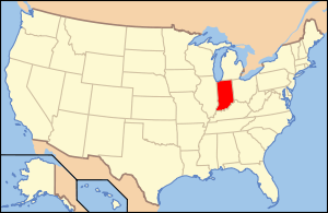 Location of Indiana in the United States
| |
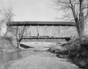
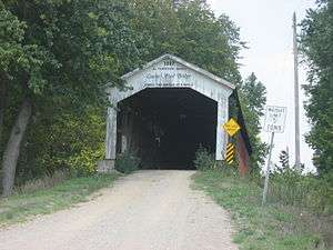
Conley’s Ford Covered Bridge was built in 1906 and crosses Big Raccoon Creek on County Road 550 East close to County Road 720 South, in Parke County, IN. The bridge is a single span Burr Arch Truss structure. The Conley's Ford Covered Bridge was built by J. P. Van Fossen.
History
Unlike the other covered bridges in Parke County, Conley's Ford was made of white pine, and not poplar. The bridge also lays claim to being the worlds fourth longest single span covered bridge.[1][5]
It was added to the National Register of Historic Places in 1978.[4]
In 1991 the bridge was resisded and reroofed. It also had its "Daniels Portals" converted into "Britton Portals" along with the build date being changed to "1907" from "1906-07". From old photos it is known that commissioners, auditors, treasurer and builder were once included on the portals.[1]
Gallery

See also
- List of Registered Historic Places in Indiana
- Parke County Covered Bridges
- Parke County Covered Bridge Festival
References
- 1 2 3 "Conley's Ford Covered Bridge (#7)". coveredbridges.com. Parke County Incorporated / Parke County Convention and Visitors Commission. Retrieved 20 September 2016.
- ↑ "Archived copy". Archived from the original on 2013-10-31. Retrieved 2009-08-07.
- ↑ http://www.indianacrossings.org/bridgeLinks/14-61-02.html
- 1 2 National Park Service (2007-01-23). "National Register Information System". National Register of Historic Places. National Park Service.
- ↑ "Indiana State Historic Architectural and Archaeological Research Database (SHAARD)" (Searchable database). Department of Natural Resources, Division of Historic Preservation and Archaeology. Retrieved 2016-06-01. Note: This includes Charles Felkner (December 1977). "National Register of Historic Places Inventory Nomination Form: Parke County Covered Bridge Historic District" (PDF). Retrieved 2016-06-01., Site map, and Accompanying photographs.