College Point, Queens
| College Point | |
|---|---|
| Neighborhood of Queens | |
|
College Point Boulevard | |
| Country |
|
| State |
|
| County | Queens |
| Named for | St. Paul's College |
| Population (2010 Census)[1] | |
| • Total | 24,275 |
| Race/Ethnicity[2] | |
| • Hispanic | 35.7% |
| • White | 32.0% |
| • Asian | 27.9% |
| • Black | 2.3% |
| • Other | 2.1% |
| Economics | |
| • Median income | $42,500 |
| ZIP code | 11356 |
| Area code(s) | 718, 347, 917 |
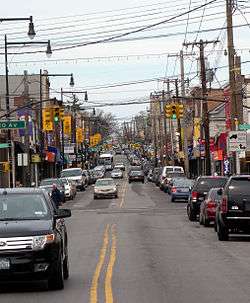
College Point is a working-middle-class neighborhood in the New York City borough of Queens. It is located north of Flushing on Flushing Bay and the East River also part of the Queens Community Board 7.[3] Willets Point Boulevard and the Whitestone Expressway are often the neighborhood's approximate boundaries with Flushing and Whitestone, respectively; College Point also borders Willets Point at the Flushing River at the extreme southwest corner. The 109th Precinct of the New York City Police Department (NYPD) serves College Point.[4] College Point is a diverse community, mostly residential with some industrial areas.
History
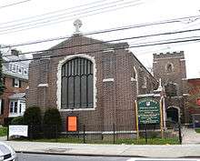
.jpg)
College Point was named for St. Paul's College, a seminary founded in 1835 by the Rev. William Augustus Muhlenberg.[5][6] The college closed around 1850. Former names include Lawrence's Neck, Tew's Neck, Flammersberg, and Strattonsport.
The original European settler of this area was Captain William Lawrence.[7] He was also the largest land holder of the original incorporators of the Town of Flushing, now in Queens. He arrived in America on the ship Planter in the 1630s. He married the oldest daughter of Richard "Bull Rider" Smith, who founded Smithtown on Long Island. With his first wife he had a son, William Jr., who married the Smiths' youngest daughter.
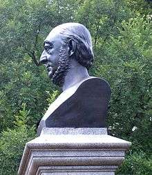
In 1854 the German-American industrialist, Conrad Poppenhusen arrived, already a prosperous manufacturer in Brooklyn of hard rubber goods, expanded his operation to this small farming community. College Point became a factory town primarily for his workers, most of them German immigrants like himself, and the tycoon became a philanthropist contributing to churches, libraries, and the Poppenhusen Institute, an educational beacon of College Point.[8] He is responsible for the first free kindergarten in America. He connected College Point to Flushing by the Flushing and North Side Railroad, later called Whitestone Branch. A monument on College Point Boulevard, one of the main streets in College Point, stands testament to Poppenhusen.[9]
College Point became a center for breweries and day trip resorts, and in the 1920s shifted towards airplane parts manufacturing.
In 1997, the Queens Historical Society bestowed a "Queensmark" award on College Point, in hopes of encouraging historical preservation of local landmark architecture.[10]
Demographics
Based on data from the 2010 United States Census, the population of College Point was 24,275, an increase of 2,868 (13.4%) from the 21,407 counted in 2000. Covering an area of 1,148.84 acres (464.92 ha), the neighborhood had a population density of 21.1 inhabitants per acre (13,500/sq mi; 5,200/km2).[1]
The racial makeup of the neighborhood was 32.0% (7,757) White, 2.3% (551) African American, 0.1% (26) Native American, 27.9% (6,774) Asian, 0.0% (2) Pacific Islander, 0.4% (97) from other races, and 1.7% (402) from two or more races. Hispanic or Latino of any race were 35.7% (8,666) of the population.[2]
Transportation
MTA Regional Bus Operations provides public bus service to College Point via the Q20A/B, Q25, Q65, and Q76 lines. No New York City Subway lines have ever been built to the area, although a spur from the IRT Flushing Line was proposed during much of the early 20th century. The Long Island Rail Road's Whitestone Branch used to run near the area.
Notable structures
- Academy Mailbox & Intercom Company – a gray-facaded warehouse on 15th Avenue built circa 1870. The building was originally used as an ice house to chill beer from a local brewery.
- College Point Little League Building – a listed on the National Register of Historic Places in 2000 as Firemen's Hall.[11]
- Farrington's Service Station – The oldest Gulf gas station in the state and possibly the oldest gas station in Queens. It was founded in the 1860s at the corner of 126th Street and 15th Avenue as a blacksmith shop and transformed into a gas station and auto service center in the early 1900s. The building has been renovated several times over the past 150 years and is still in operation on the same corner.
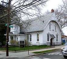
- First Reformed Church – A church built in 1873 in the small town New England style. The church is on a large lot, has a bell tower, and is adorned with "gingerbread" trim. On June 6, 2008 a fire caused damage in the steeple, which was repaired, maintaining the historical appearance of the building. (Up on 119th Street)
- Flessel's Restaurant – Recently demolished in the construction boom, Flessel's stood as a testament to the summer resorts and beer gardens that once marked College Point.
- Flushing Airport – Opened in 1927 along the shore of Flushing Bay, the airport had been a busy aviation hub before LaGuardia Airport was built in 1939 about one mile away. It carried the IATA code FLU. In 1977, a Piper Twin Comanche crashed shortly after taking off from the airport. The incident eventually led to the closing of this airport in 1984.[12] The site remains abandoned, although plans have been proposed over the years to convert it into a blimp-port or office park. Given natural deterioration of the hangars and concrete runways, however, it is likely that the site will simply return to being natural wetlands.[13]
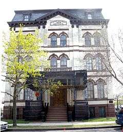
- Poppenhusen Institute – Built in 1868 by Conrad Poppenhusen, the founder of College Point. The architecture features a French Second Empire Mansard roof topping off the three Italianate style stories. During the entire Civil War, the Poppenhusen Institute building housed the disassembled Abraham Lincoln's log cabin. After the war, it was returned to Hodgenville Kentucky, the current site of the log cabin. The Institute's other claim to fame is that it conducted America's first free kindergarten. Originally a town hall, this City Landmark now serves as a cultural and historical center and offers a variety of classes and activities.
- Poppenhusen Library – An Andrew Carnegie library, built in 1904 featuring a copper roof, is still active as a branch in the Queens Library system.[14]
- Schleicher Court – A mansion built in 1853 that also operated as the Grand View Hotel.[15] The house was divided into apartments and literally sits in the center of 123rd street. The house suffered an electrical fire on July 9, 2008 and was forcibly vacated by the Department of Buildings.[16]
- Spangelberg Mansion – A yellow and white-facaded mansion circa 1860 now also divided into apartments.
Schools and churches
Public elementary schools, defined as kindergarten through 5th grades, include PS 29 and PS 129. College Point is home to St. Fidelis Parish, founded in 1856. The present church was completed in 1906. Adjacent to the church is the grave of Father Huber, the founding pastor. For over 150 years, the parish conducted an elementary school including kindergarten through 8th grades. In 1924, St. Fidelis School, a three story building of 18 classrooms, opened its doors on the present 14th Avenue and 124th Street. In 1961, the 12 classroom annex was opened. During most of these years, it was staffed by the Dominican Sisters of Amityville (Dominican Sisters of the American Congregation of the Holy Cross). Due to significant demographic changes in College Point, the elementary school was finally closed in June 2013.
St. Agnes Academic High School, a private Catholic high and independent of St. Fidelis parish, has been operating for over one hundred years. In its early years, it was very briefly co-educational, but is now restricted to girls. It is owned and still staffed by the Dominican Sisters of Amityville, assisted by lay men and women. The Dominican Sisters reside in Saint Agnes Convent as well as the Harbor of Grace Convent, which was the original convent for this community. College Point is also home to St. John's Lutheran School, another elementary program.
St. Fidelis Roman Catholic Church,[17] St. Paul's Episcopal, St. John's Lutheran, and The First Reformed Church of College Point host the community's four largest congregations.
A large, new New York City Police Academy campus is being built at 20th Avenue and College Point Boulevard.[18]
Recreation and attractions
Parks
- MacNeil Park, formerly known and still affectionately called Chisholm's by many locals (after the family that owned the mansion that once stood in the park), features a water front view, full playground, basketball and handball courts, and baseball fields. The Chisholm's Mansion was located at the highest part of the park, overlooking the East River and Rikers Island. This mansion served as the summer residence of Mayor Fiorello LaGuardia during his term of office as Mayor of New York.
- Poppenhusen Playground is a park for primary school-aged children.
- College Point Park, the former location of P.S. 27, is located across the street from Poppenhusen Library.It is called "27" by many locals. It has basketball and handball courts as well as an adjacent municipal parking lot. A hot-dog vendor is often in the park on days with good weather and has handballs available for sale.
- Powell's Cove Park, an environmental waterfront park, lies on the border of College Point and Malba and affords a great view of the Bronx Whitestone Bridge
- Frank Golden Memorial Park, located behind the strip mall on 14th Avenue, features 4 baseball diamonds and is used by local softball leagues.
Sports
- College Point Sports Park: College Point is home to a newly reconstructed hockey rink on Ulmer Street complete with floodlights and bleachers, which was part of a larger reconstruction of the College Point Fields. The baseball fields and hockey rink are now New York City Department of Parks and Recreation Fields, but the entire property used to belong to the College Sports Association, which leased the fields from the City for $1 a day. The fields were to be rebuilt in the late 1990s, but due to complications due to the EnViroFill dumping construction debris, in 1999, the construction was stopped, the fields closed and the lease revoked. The local leagues nearly collapsed due to the closure of the fields, but under the leadership of Jerry Castro, President of the Little League until 2006, and Tony Mongeluzzi, President of the Roller Hockey League, the leagues survived and are now thriving.
- College Point Little League: The College Point Little League, based out of the College Point Little League Building, is chartered by Little League Baseball in Williamsport, and serves the College Point, Flushing, and Whitestone areas of Queens. The College Point Little League is an all volunteer organization dedicated to providing boys and girls, ages 5 through 18, a place where they can build their baseball skills while learning good sportsmanship, fair play, teamwork, and most of all, having fun.
- College Point Stars: The College Point Stars (not affiliated with the College Point Little League) are a youth baseball team that advanced to the 2007 Cal Ripken Babe Ruth League Division World Series, coached by Nelson Santiago, who was involved with the Little League for several years, including managing a team of 11-year-olds to a second-place finish in New York State in the summer of 2006.
Shopping and entertainment
- Farrington's Service Station was established in the 1860s on the corner of 126th Street and 15th Avenue as a blacksmith shop. John Farrington, a blacksmith, later transformed it into a gas station and auto service center in the early 1900s. The Farrington family still owns and operates the gas station on the same corner. It is the oldest Gulf station in the state.
- Empire Market on College Point Boulevard has sold German meats and groceries since 1920 and is owned by a third-generation German family. The store also offers a wide variety of candy in glass jars and is a favorite among children.
- College Meat Center, family owned and operated since 1963, has been serving local residents for over 40 years, surviving a fire in the 1980s.
- A strip mall-style shopping center on 20th Avenue includes Target, TJ Maxx, BJ's Wholesale Club, Modell's, Old Navy, Babies "R" Us, and a Waldbaum's supermarket. There is also a McDonald's and Starbucks in the middle of this center's parking lot.
- The Point on 127th Street and 20th Avenue, an eco-friendly lifestyle center, was opened in 2012, offering a fresh architectural appeal, spectacular views of Manhattan skyline, and a host of retailers including restaurants, a supermarket, a spa, a swimming pool, a karaoke bar, a hotel, children’s corner, rooftop garden restaurant and lounge and various shops.
- The College Point Multiplex Cinemas offers 12 screens of movies, as well as a mini-arcade.
Notable residents
Notable current and former residents of College Point include:
- David Gallagher (born 1985), actor who portrayed "Simon Camden" on the show 7th Heaven
- Steve Karsay (born 1972), Major League Baseball pitcher.[19]
- Conrad Poppenhusen (1818-1883), founder of College Point, education innovator, hard rubber manufacturer, railroad tycoon and German-born philanthropist
References
- 1 2 Table PL-P5 NTA: Total Population and Persons Per Acre - New York City Neighborhood Tabulation Areas*, 2010, Population Division - New York City Department of City Planning, February 2012. Accessed June 16, 2016.
- 1 2 Table PL-P3A NTA: Total Population by Mutually Exclusive Race and Hispanic Origin - New York City Neighborhood Tabulation Areas*, 2010, Population Division - New York City Department of City Planning, March 29, 2011. Accessed June 14, 2016.
- ↑ Queens Community Boards, New York City. Accessed September 3, 2007.
- ↑ "NYPD - Precincts". nyc.gov. Retrieved 28 May 2015.
- ↑ College Point, Times Ledger, January 20, 2000. Accessed October 24, 2007. "North of Flushing is College Point, named College Point in 1835 by the Rev. William Augustus Muhlenberg, who established St. Paul's College there in 1838."
- ↑ College Point, Forgotten New York.
- ↑ College Point Park, New York City Department of Parks and Recreation. Accessed October 24, 2007.
- ↑ During the Civil War, the Poppenhusen Institute housed Abraham Lincoln's Log Cabin, for safekeeping. After the Civil War, it was returned to its original location in Kentucky. The Benevolent Tycoon Newsday
- ↑ Conrad Poppenhusen Statue, New York City Department of Parks and Recreation. Accessed September 10, 2007.
- ↑ Queensmark Comes to College Point. Accessed September 10, 2007.
- ↑ National Park Service (2010-07-09). "National Register Information System". National Register of Historic Places. National Park Service.
- ↑ "1977". The Queens Spin. Queens Tribute.
- ↑ See:
- Buglione, Nick (2000-08-31). "From Flying High To Sinking Deep: The Life & Death Of An Airport". Queens Tribune. Retrieved 2016-10-10.
- "Abandoned & Little-Known Airfields: New York City, Queens". airfields-freeman.com. Retrieved 28 May 2015.
- "FLUSHING AIRPORT Part 1". Forgotten New York. 2012-05-30. Retrieved 2016-10-10.
- "RETURN TO THE WEEDY GREEN YONDER: FLUSHING AIRPORT Part 2". Forgotten New York. 2012-05-30. Retrieved 2016-10-10.
- "Future of Flushing Airport Site [Archive] - Wired New York Forum". wirednewyork.com. Retrieved 28 May 2015.
- ↑ "Queens Library". Queens Library. Retrieved 28 May 2015.
- ↑ "COLLEGE POINT, Queens, Part 2". Forgotten New York. 2006-05-12. Retrieved 2016-10-10.
- ↑ Queens Crapper. "Queens Crap: Plenty of vacancies at the old Grand View Hotel". queenscrap.blogspot.com. Retrieved 28 May 2015.
- ↑ "St. Fidelis School, College Point, NY 11356, Catholic Elementary School, Grades Nursery through 8th". stfidelis.org. Retrieved 28 May 2015.
- ↑ Rhodes, Liz (December 22, 2011). "Police Academy rises in Queens". Queens Chronicle. Retrieved 2011-02-11.
- ↑ Keys, Lisa. "At Home with … Steve Karsay – No. 31's Flavor", New York Post, August 14, 2004. Accessed October 10, 2016. "The reliever grew up in a small two-bedroom in College Point, Queens. It’s only a little more than 10 miles away, but light years away in spirit."
Further reading
| Wikimedia Commons has media related to College Point, Queens. |
Coordinates: 40°47′15″N 73°50′46″W / 40.78750°N 73.84611°W