Geography of East Timor
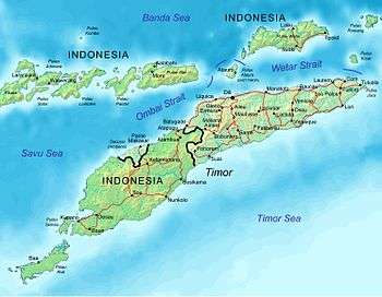
Map of East Timor indicating cities and principal roads.
This article describes the geography of East Timor.
- Location
- Southeast Asia (or Oceania depending on definitions),[lower-alpha 1] northwest of Australia in the Lesser Sunda Islands at the eastern end of the Indonesian archipelago; note - East Timor includes the eastern half of the island of Timor, the Ocussi-Ambeno region on the northwest portion of the island of Timor, and the islands of Atauro and Jaco
- Geographic coordinates
- 8°50′S 125°55′E / 8.833°S 125.917°E
- Map references
- Southeast Asia, Wallacea
- Area
-
- Total: 14,874 km²
- Land: 14,874 km²
- Water: 0 km²
- Land boundaries
-
- Total: 2,538 km (1,577 mi)
- Border countries: Indonesia (253 km or 157 mi)
- Coastline
- 706 km (439 mi)
- Maritime claims
-
- Territorial sea: 12 nmi
- Contiguous zone: 24 nmo
- Exclusive fishing zone: 200 nmi
Climate
- Tropical; hot, humid; distinct rainy and dry seasons
- Terrain
- Mountainous
- Elevation extremes
-
- Lowest point: Timor Sea, Savu Sea, and Banda Sea 0 m
- Highest point: Tatamailau (2,963 m or 9,721 ft)
- Natural resources
- Gold, petroleum, natural gas, manganese, marble
- Land use
-
- Arable land: 10.1%
- Permanent crops: 4.9%
- Permanent pasture: 10.1%
- Forest: 49.1%
- Other: 25.8% (2011)
- Irrigated land
- 346.5 km2 (134 sq mi) (2003)
- Natural hazards
- Floods and landslides are common; earthquakes; tsunamis; tropical cyclones
- Environment - current issues
- Widespread use of slash and burn agriculture has led to deforestation and soil erosion
- Environment - international agreements
- Biodiversity, Climate Change, Climate Change-Kyoto Protocol, Desertification
- Geography - note
- 'Timor' is a Portuguese derivation of 'Timur' Malay word for "Orient"; the island of Timor is part of the Malay Archipelago and is the largest and easternmost of the Lesser Sunda Islands.
- East Timor is the only Asian nation to lie entirely within the Southern Hemisphere.
References
- Much of the material in this article is adapted from the CIA World Factbook 2000 and 2012.
This article is issued from Wikipedia - version of the 9/30/2016. The text is available under the Creative Commons Attribution/Share Alike but additional terms may apply for the media files.