Hendry County, Florida
| Hendry County, Florida | ||
|---|---|---|
| County | ||
| Hendry County | ||
 The Hendry County Courthouse at LaBelle in 2010. | ||
| ||
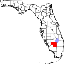 Location in the U.S. state of Florida | ||
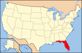 Florida's location in the U.S. | ||
| Founded | May 11, 1923 | |
| Named for | Francis A. Hendry | |
| Seat | LaBelle | |
| Largest city | Clewiston | |
| Area | ||
| • Total | 1,190 sq mi (3,082 km2) | |
| • Land | 1,153 sq mi (2,986 km2) | |
| • Water | 37 sq mi (96 km2), 3.1% | |
| Population (est.) | ||
| • (2015) | 39,119 | |
| • Density | 34/sq mi (13/km²) | |
| Congressional districts | 20th, 25th | |
| Time zone | Eastern: UTC-5/-4 | |
| Website |
www | |
Hendry County is a county located in the U.S. state of Florida. As of the 2010 census, the population was 39,140.[1] Its county seat is LaBelle.[2]
Hendry County comprises the Clewiston, Fla. Micropolitan Statistical Area.
History
Hendry County was created in 1923. It was named for Captain Francis A. Hendry, one of the first settlers.
Geography
According to the U.S. Census Bureau, the county has a total area of 1,190 square miles (3,100 km2), of which 1,153 square miles (2,990 km2) is land and 37 square miles (96 km2) (3.1%) is water.[3] The county borders Lake Okeechobee; the Lake Okeechobee Scenic Trail runs through Hendry County.
Adjacent counties
- Glades County - north
- Martin County - northeast
- Okeechobee County -
northeast point in the middle of Lake Okeechobee - Palm Beach County - east
- Broward County - southeast
- Collier County - south
- Lee County - west
- Charlotte County - west
Demographics
| Historical population | |||
|---|---|---|---|
| Census | Pop. | %± | |
| 1930 | 3,492 | — | |
| 1940 | 5,237 | 50.0% | |
| 1950 | 6,051 | 15.5% | |
| 1960 | 8,119 | 34.2% | |
| 1970 | 11,859 | 46.1% | |
| 1980 | 18,599 | 56.8% | |
| 1990 | 25,773 | 38.6% | |
| 2000 | 36,210 | 40.5% | |
| 2010 | 39,140 | 8.1% | |
| Est. 2015 | 39,119 | [4] | −0.1% |
| U.S. Decennial Census[5] 1790-1960[6] 1900-1990[7] 1990-2000[8] 2010-2015[1] | |||
As of the census[9] of 2000, there were 36,210 people, 10,850 households, and 8,137 families residing in the county. The population density was 31 people per square mile (12/km²). There were 12,294 housing units at an average density of 11 per square mile (4/km²). The racial makeup of the county was 66.08% White, 14.75% Black or African American, 0.80% Native American, 0.45% Asian, 0.03% Pacific Islander, 14.67% from other races, and 3.22% from two or more races. 39.59% of the population were Hispanic or Latino of any race.
In 2000 there were 10,850 households out of which 40.2% had children under the age of 18 living with them, 55.7% were married couples living together, 12.5% had a female householder with no husband present, and 25.0% were non-families. 18.6% of all households were made up of individuals and 7.3% had someone living alone who was 65 years of age or older. The average household size was 3.09 and the average family size was 3.44.
In the county the population was spread out with 30.0% under the age of 18, 13.3% from 18 to 24, 28.3% from 25 to 44, 18.3% from 45 to 64, and 10.1% who were 65 years of age or older. The median age was 30 years. For every 100 females there were 125.0 males. For every 100 females age 18 and over, there were 131.4 males.
The median income for a household in the county was $33,592, and the median income for a family was $34,902. Males had a median income of $25,896 versus $20,070 for females. The per capita income for the county was $13,663. About 16.9% of families and 24.1% of the population were below the poverty line, including 29.9% of those under age 18 and 15.0% of those age 65 or over.
2010 Census
In 2010 the population of Hendry Country was 39,140. The racial and ethnic composition of the population was 34.9% non-Hispanic white, 13.4% black or African American, 1.7% Native American, 0.7% Asian, 0.1% Pacific Islander, 0.1% non-Hispanic reporting some other race, 2.7% reporting two or more races and 49.2% Hispanic or Latino.[10]
Politics
| Year | Republican | Democratic | Other |
|---|---|---|---|
| 2016 | 55.8% | 41.5% | 2.8% |
| 2012 | 52.4% | 46.5% | 1.1% |
| 2008 | 52.9% | 45.8% | 1.3% |
| 2004 | 58.9% | 40.5% | 0.6% |
| 2000 | 58.3% | 39.8% | 1.9% |
Libraries
The Hendry County Library Cooperative has three branches:
- Clewiston
- Barron
- Harlem
Communities
Cities
Census-designated places
Unincorporated communities
- Felda
- Pioneer Plantation
- Montura Ranch Estates
- Flaghole
- Ladeca Acres
Transportation
Airports
See also
References
- 1 2 "State & County QuickFacts". United States Census Bureau. Retrieved February 14, 2014.
- ↑ "Find a County". National Association of Counties. Retrieved 2011-06-07.
- ↑ "US Gazetteer files: 2010, 2000, and 1990". United States Census Bureau. 2011-02-12. Retrieved 2011-04-23.
- ↑ "County Totals Dataset: Population, Population Change and Estimated Components of Population Change: April 1, 2010 to July 1, 2015". Retrieved July 2, 2016.
- ↑ "U.S. Decennial Census". United States Census Bureau. Retrieved June 14, 2014.
- ↑ "Historical Census Browser". University of Virginia Library. Retrieved June 14, 2014.
- ↑ "Population of Counties by Decennial Census: 1900 to 1990". United States Census Bureau. Retrieved June 14, 2014.
- ↑ "Census 2000 PHC-T-4. Ranking Tables for Counties: 1990 and 2000" (PDF). United States Census Bureau. Retrieved June 14, 2014.
- ↑ "American FactFinder". United States Census Bureau. Retrieved 2011-05-14.
- ↑ 2010 general demographic report for Hendry County
External links
| Wikimedia Commons has media related to Hendry County, Florida. |
Government links/constitutional offices
- Hendry County Board of County Commissioners official website
- Hendry County Economic Development Council
- Hendry County Supervisor of Elections
- Hendry County Property Appraiser
- Hendry County Sheriff's Office
- Hendry County Tax Collector
Special districts
Judicial branch
- Hendry County Clerk of Courts
- Public Defender, 20th Judicial Circuit of Florida serving Charlotte, Collier, Glades, Hendry, and Lee Counties
- Office of the State Attorney, 20th Judicial Circuit of Florida
- Circuit and County Court for the 20th Judicial Circuit of Florida
Tourism links
Museum and Library Resources
- The Caloosa Belle, the local newspaper for Hendry County, Florida fully and openly available in the Florida Digital Newspaper Library
 |
Glades County | Martin County and Okeechobee County | | |
| Charlotte County and Lee County | |
Palm Beach County | ||
| ||||
| | ||||
| Collier County | Broward County |
Municipalities and communities of Hendry County, Florida, United States | ||
|---|---|---|
| Cities | | |
| CDPs |
| |
| Unincorporated community | ||
| Indian reservations | ||
Coordinates: 26°33′N 81°10′W / 26.55°N 81.17°W