Clarksville, California
Coordinates: 38°39′18″N 121°03′09″W / 38.65500°N 121.05250°W
| Clarksville | |
|---|---|
| Unincorporated community | |
 Clarksville  Clarksville Location in California | |
| Coordinates: 38°39′18″N 121°03′09″W / 38.65500°N 121.05250°W | |
| Country | United States |
| State | California |
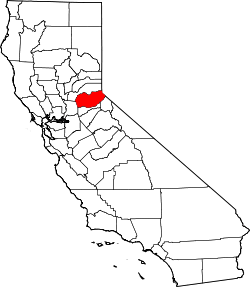
| County | El Dorado County |
| Elevation[1] | 676 ft (206 m) |
Clarksville ( Tong Ranch) is an unincorporated community in El Dorado County, California.[1] It is located 14 miles (23 km) west-southwest of Placerville,[2] at an elevation of 676 feet (206 m).[1]
A post office operated at Clarksville from 1855 to 1924 and from 1927 to 1934.[2]
References
This article is issued from Wikipedia - version of the 7/5/2016. The text is available under the Creative Commons Attribution/Share Alike but additional terms may apply for the media files.