Clarendon Way
Coordinates: 51°03′43″N 1°18′58″W / 51.062°N 1.316°W
| Clarendon Way | |
|---|---|
| Length | 26 mi (42 km) |
| Location | Southern England |
| Designation | UK National Trail |
| Trailheads |
Salisbury Cathedral, Wiltshire Winchester Cathedral, Hampshire. |
| Use | Hiking |
The Clarendon Way is a recreational footpath in Hampshire and Wiltshire, England. It starts beside the waters of the River Itchen in the centre of Winchester and ends near the River Avon at Salisbury Cathedral. The path passes through the Clarendon Estate and close to the 12th century ruins of Clarendon Palace. The path also passes through Farley Mount Country Park and the villages of Pitton, The Winterslows, Broughton and King's Somborne.
The footpath is waymarked by metal and plastic disks attached to wooden and metal posts, trees and street furniture. This route is shown as a series of green diamonds on Ordnance Survey 1:25,000 maps and as a series of red diamonds on Ordnance Survey 1:50,000 maps.
Maps
These maps show the footpath in relation to nearby major roads. Maps are not on the same scale.
-
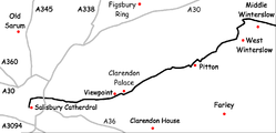
Salisbury to Middle Winterslow
-
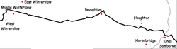
Middle Winterslow to King's Somborne
-

King's Somborne to Winchester
See also
External links
- "The Clarendon Way". Hantsweb. Hampshire County Council. Retrieved 30 March 2015.