Chuadanga District
| Chuadanga চুয়াডাঙ্গা | |
|---|---|
| District | |
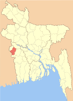 Location of Chuadanga in Bangladesh | |
| Coordinates: BD 23°36′N 88°42′E / 23.60°N 88.70°ECoordinates: BD 23°36′N 88°42′E / 23.60°N 88.70°E | |
| Country |
|
| Division | Khulna Division |
| Area | |
| • Total | 1,174.10 km2 (453.32 sq mi) |
| Population (2011 census) | |
| • Total | 1,129,015 |
| • Density | 960/km2 (2,500/sq mi) |
| Time zone | BST (UTC+6) |
Chuadanga (Bengali: চুয়াডাঙ্গা; Chuađaņga), Chuadanga district or Chuadanga Zilla (চুয়াডাঙ্গা জেলা) is the name of a Western district (zilla) of Bangladesh. It is a part of the Khulnau administrative division that covers most districts in the south-west of the country.
History
According to Greek historians, as well as from geographical formations, this region formed a part of the kingdom of Gangaridhi. A city by the name of Gangey is also thought to be located in this region.
During British rule, the region was the location of several uprisings, including Wahabi Movement (1831), Faraizi Movement(1838–47), Sepoy Rebellion (1857), Indigo Rebellion (1859–60), Khilafat Movement (1920), Swadeshi Movement (1906), Non-cooperation movement, Violation of Law and Salt Satyagraha (1920–40), Quit India Movement or August Revolt (1942).
Under British rule, Chuadanga was a sub-division within Nadia District. During partition, in 1947, excepting Krishnanagar thana (still under Nadia in West Bengal). History of Chuadanga can be found in Nadia District Gazetteer during British rule.[1]
During Bangladesh Liberation War of 1971, Chuadanga was the location of more than 100 battles between the Pakistan Army and the Mukti Bahini pro-independence forces.[2] On 26 March 1971, the first war command, the South Western Command of Bangladesh, was set up in this area, under the leadership of Major Abu Osman Chowdhury and Dr. Ashabul Haque Joarder (expired at 89 on 7 October 2010). Before that at about 09:30 in the morning of the same day in a makeshift public meeting arranged at Borobazar crossing, Dr. Ashabul Haque Joarder declared all out war against the occupation of Pakistan military forces. This region was also the place where Bangladesh Red Cross Society was founded. During the liberation war the government in exile declared Chuadanga to be the provisional capital of the People's Republic of Bangladesh. During the Bangladesh Liberation War more than one hundred documented direct encounters took place between the Pakistan Army and the freedom fighters (Mukti Bahini) in Chuadanga district. According to records Chuadanga was liberated from the hands of occupying Pakistan army on 7 December 1971, nine days before the invading army officially surrendered to the Mitro Bahini (allied forces of Mukti Bahini and Indian Army).
Marks of the Liberation War genocide in the district include a spot behind the Chuadanga Central Hospital.[2]
1971 liberation war
The Bir Protik award for gallantry was awarded to Harunur Rashed of Chuadanga District. He was killed on November 27 at Jadupur, under Chuadanga Sadar Upazila. He is buried at Jadupur in the tomb on the day after the elimination of Johor. He fought heroically in many parts of Chuadanga. Every 16 December and 26 March Chuadanga honours his family. He has a son who was born six months after his father's death. His wife's name was Mst. Suraton Nesa. She died in 2004. One day he though that we Will Be Free. Now we are free from the oppressor. We are proud of Harunur Rashed. He hoped that our district could be a full of peace.
Geography
The district has an area of 1,157.42 (km)². It shares domestic borders with the Kushtia District on the northeast, Meherpur on the northwest and Jhenaidaha on the south and southeast. On its southwest lies the Nadia District (in the state of West Bengal in India). The annual average maximum temperature is 40.1 °C and the average for the minimum is 8.2 °C, while 1,467 mm is received on average each year. The entire Chuadanga district lies within the Ganges Delta, with rivers Mathabhanga, Bhairab, Kumar, Chitra, and Nabaganga flowing through the district.
Administration
Until the Partition of India in 1947 Chuadanga sub-division was within Nadia district.
Administrator of Zila Porishod: Major (Rtd.) Alimuzzaman Zoarder
Deputy Commissioner (DC): Begum Sayma Younus[3]
Subdivisions
Chuadanga district is divided into four upazillas.
Demographics
The population of the district was 987,382 during the 2001 national survey with 50.82% male and female 49.18% compositions.
Religion
The district of Chuadanga consists 3554 mosques, 218 temples, 13 churches and three Buddhist temples.
Education
The different kinds of educational institutions are as follows:
- Colleges - 12
M.S.Zoha Agricultural College,Hardi,Alamdanga,Chuadanga Chuadanga Govt.College,Chuadanaga
- High schools - 48
- Junior schools - 7
- Government Primary schools - 257
- Non-government Primary schools - 120
- Primary Training institute - 1
- Vocational Training institute 1
- Nursing institute 1
- Madrasas - 63
- Kindergarten schools - 3
- English medium school -2
University-1 First Capital University of Bangladesh,
Noted old educational institutions include the Victoria Jubilee Government High School (est. 1880), Alomdaņga pilot High School (est. 1914), Natudaôho High School (est. 1906),Carew's High School(1947), Gokulkhali High School ( est. 1947), Jibonnôgor Pilot High School (est. 1957),damurhuda pilot high school and Hajar Duari School.
According to the SSC (Secondary School Certificate) result some schools are really doing better. Among these Carew's High School, Victoria Jubilee High School,Government Girls' School and Nilmonigônj High School are mentionworthy. Are also Secondary Name: "BISHNUPUR SECONDARY SCHOOL" Is establish 1964 & Damurhuda upojila
Economy
Most of this small district is dedicated to agriculture. Occupational distributions clearly show this with agriculture employing 68% of the labour force, while only 12% are involved in commerce. Total cultivable land amounts to 894.20 km², of which 57% is under some sort of irrigation.
Besides agriculture the district is now experiencing industrial growth. Major industries include Zaman Group of Industries, Bangas bread and biscuit, Tallu Spinning mills Ltd,Carew & Company Bangladesh Limited etc.Carew & Company Bangladesh Limited(1933),which is situated at Darshana of Damurhuda Upazilla of Chuadanga district is the largest sugar mill of Bangladesh,Carew & Company has a distillery also which is the lone wine producing plant of Bangladesh, Carew & Company Bangladesh Limited is an enterprise of Bangladesh Sugar & Food Industries Corporation(BSFIC). BSFIC is an autonomous body of Ministry Of Industries(Government of Bangladesh).
Transportation
Chuadanga is connected to four of its neighbouring districts (Kushtia; Jessore; Jhenidah and Meherpur) through inter-district highways and connected to Jessore and Kushtia through Railway.
The district is connected to the rest of the country by three highways and railway. There are 203 km of finished road, 211 km herring-bone and 132 km mud road. Total length of railway tracks is just over 50 km that connect the three railway stations inside the district with the country's railway network.
The entire transportation system is comparatively better than other districts. You can access to any of its upa-zilla by 30 minutes travel by motor vehicle. To reach to Dhaka you need to spend 4 to 5 hours. To reach to Calcutta you need less time to reach Dhaka. That makes the place important during our liberation in 1971.
Earlier the district was connected to other parts of the country by its major river The Matha Vanga but now the river route is invalid due to siltation on river beds.
The people usually use Bus and train for long journey and for local travels they use Rickshaw, human pulled van etc. For personal use they use cycle and motor cycle frequently.
For goods transportation, a human driven van called "Nosimon" is often used.
Karpashdanga [4] is an old historical village of Chuadanga District, located in the border area of Bangladesh with West Bengal state of India. This village was famous in the region for rural business centre from long ago. The big Bazaar on the bank of the Bhairab river was one of the oldest rural commercial meeting place from the Mughal to the British era. There is a historical 'Nil-Kuthi' on the Bank of the river Bhairab. This 'Nil-Kuthi was one of the headquarters of the then East India Company during British Raj for administering the cultivation of indigo in this area. The main part of the Nil-Kuthi is now in a ruined state. The other part has been renovated and converted to a girl's secondary school in 1983. The old name of the village was 'Nishchintapur'. There is also a graveyard in the Nil-Kuthi area in Karpashdanga village used to bury the white people of East India company when they deceased. It is heard that one such name of a white man was Mr. Barkas (locally people used to call him Barkosh shaheb) who was very tyrant administrator during British rule in that area. It is said as a proverb that he was such a ruler, he could force tigers and buffaloes to drink at the same place of the river without showing any hostility to each other. There is a large section about 'Kapasdanga' in Chapter 15 of Nadia District Gazetteer.
Another historical event associated with Karpashdanga village is that the rebel poet Kazi Nazrul Islam stayed in this village for some time and during his participation with non-cooperation movement Swadeshi Movement organised against British Raj. There were few active members of the 'Swadeshi' group, whose descendant live in western area of Christian community in Karpashdanga. A Nazrul museum has been established in the local high school with the collection of items Kazi Nazrul Islam left in that house. There is a large Christian community in the village. There are two large churches belong to two groups of Christian e.g. catholic and Protestants. There is also a missionary hospital run by the Christian missionaries and is famous in the area for medical treatment facilities and care of patient.
Chuadanga at a glance
| Land use | Area (in Acre) |
|---|---|
| Total Land Area | 283,679 |
| Cultivable Area | 226,754 |
| Fallow Land | 15,245 |
| Area Under Forest | 10 |
| Area Irrigated | 126,760 |
| Area Under River | 549 |
| Name of Items | Total No. | Length (in km.) |
|---|---|---|
| Rivers | 11 | 121 |
| Metal Road | 16 | 177 |
| Semi Metal Road | 54 | 120 |
| Kutcha Road | 446 | 1,258 |
| Rail Road | - | 52 |
| Town Malls (Haţ) | 68 | - |
| Name of Items | Total Number |
|---|---|
| Poverty Alleviation | 12 |
| Rehabilitation of Destitute | 11 |
| Family Planning | 6 |
| Rural/Adult Education | 76 |
| Agriculture & Food | 60 |
| Road & Communication | 57 |
| Health | 3 |
| Total | 195 |
See also
References
| Wikimedia Commons has media related to Chuadanga District. |
- ↑ Nadia District Gazetteer.
- 1 2 Ahmed, Rajib (2012). "Chuadanga District". In Islam, Sirajul; Jamal, Ahmed A. Banglapedia: National Encyclopedia of Bangladesh (Second ed.). Asiatic Society of Bangladesh.
- ↑ "20 districts get new DCs". The Daily Star. UNB. 11 June 2015.
- ↑ Karpashdanga
| Upazila/Thana: | ||
|---|---|---|

| Barisal Division | 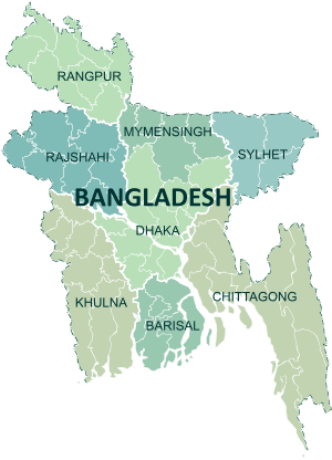 | |
|---|---|---|
| Chittagong Division | ||
| Dhaka Division | ||
| Khulna Division | ||
| Mymensingh Division | ||
| Rajshahi Division | ||
| Rangpur Division | ||
| Sylhet Division | ||