Chocolá

Chocolá is a Preclassic Southern Maya site whose developmental emphasis was from ca. 1000 BC to AD 200. The site lies within the Southern Maya area.
Chocolá is in the San Pablo Jocopilas municipality in the southern Suchitepéquez department of Guatemala. A modern village lies on top of and within the ancient site.
Importance of the site
Lying on a plateau below volcanic mountain ridges to the north and east, and at a height of 500–1000 meters, the site consists of three general groupings extending over ca. 6 by 2 kilometers, oriented north-to-south. To the north, great platform mounds consisted of elite residences, with elaborate hydraulic networks of stone-lined canals bringing water in from underground springs.

In these precincts, large palaces were built; from Structure 7-1, ca. 25 by 25 meters and 5 meters high, caches of fine complete vessels were recovered, likely dedicatory offerings placed during the construction of the edifice.
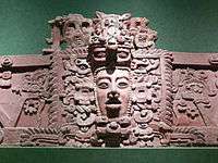
In the ancient central district further south, pyramidal mounds up to 25 meters held administrative structures. Archaeoastronomical research has tentatively identified crucial alignments from structures in the administrative center of the city that reflect primordial measurements that underlay development of the Maya calendar.[1] Still further south, flatter areas contained commoner houses and workshops. Thus far, hundreds of thousands of artifacts have been found, including many whole vessels, sculptured monuments and altars, and figurines, most dating to the Preclassic. Around the site are caves still sacred to local ritualists.
Researchers have hypothesized that one reason for the early development of such high complexity at Chocolá is the intensive cultivation of cacao for long-distance trade.[2] Based on older as well as still accumulating evidence, scholars assume that innovative developments occurred in the southern Mesoamerican area during the Preclassic period (1500 BC – AD 200) that strongly influenced the later great Mesoamerican civilizations.[3] However, scholars lack a clear sense of even the broader events and processes that shaped southern Guatemala's history and gave it its peculiar and, as long assumed, seminal character. Investigations at Kaminaljuyu, in the central Guatemalan highlands, and Takalik Abaj, in southwestern Guatemala, over recent decades showed the strong relationship between these two regions. These centers, along with other nearby sites, like Chocolá, participated in distinct political networks and shared ideologies, technologies, and economics.
Chocola also participated in the Potbelly sculpture tradition. One such monument was found there.[4]
Archaeological investigations

A complex of more than 100 structures was discovered by Karl Sapper in the last years of the 19th century[5] and a few mounds were excavated by Robert Burkitt in the 1920s.[6] The discovery by Burkitt of Monument 1, a stela carved in the "Miraflores" style, sparked interest among scholars, suggestive as it was that Chocolá may have been an important polity early on with distinct political connections with Kaminaljuyu.[7] This stela bears extraordinary similarities both in style and content to Kaminaljuyu Stela 10, a gigantic throne and the site's single largest monument.[8] In 2003, long-term excavations were initiated by the Proyecto Arqueologico Chocola (PACH). These investigations are exploring the social and cultural developments that led to the rise of the Classic Maya, with sophisticated city-states, hieroglyphic literacy, exquisite ceramics, and the most advanced mathematics and astronomy in the New World.
Also in 2003 a large portion of work was focused on the division of Chocola into three different sectors. The first at the north side of the city containing large, low and grouped platforms, water directing systems, river cobble structures and possibly served as a place of residence for the upper class. The second being in the center of the site with large mounds (in a pyramidal form) which may have served a purpose as an area of administration and public ceremonies. The third sector, lying at the southern part of the site contained similar findings to that of the north except the architecture of houses and workshops had less complicated architecture and contained signs of intensive agriculture, and therefore probably served as a residential area for the common people. But even with this information not much research has been done on the site and only about 5.5x2km has been excavated up to this point.
Water and chocolate

Discovered between 2003 and 2005, networks of stone-lined or stone-enclosed drains and conduits, extending at least 1.5 kilometers, demonstrate sophisticated hydraulics. Radiocarbon dating situates the system in the Late Middle Preclassic period, or as early as 500 BC.[9] Early and later Post-Conquest ethnohistory attests that Soconusco, Suchitepéquez, and Escuintla were important centers for the production of cacao, a high water-demand plant. The same ethnohistory records very dense populations at the time of the Conquest and fierce fighting between various caciques for control of cacao in an area where today one finds Mazatenango, Cuyotenango, Zapotitlán, San Antonio, and Samayac, all indicated by ethnohistory to have been significant centers of cacao production and trade, and all clustered closely around the Chocolá site. While such ethnohistoric information cannot be relied on as direct evidence to characterize events and processes from millennia earlier, it seems reasonable to use these data as a guide for what one could look for, including evidence of large-scale exchange, perhaps most plausibly, of obsidian for cacao. If, indeed, archaeological evidence can be found to support intensive cacao cultivation at and around Chocolá, a yet stronger case will be made for the Southern Maya area as crucial to the rise of Maya civilization.
Notes
References
- Burkitt, Robert (1930) Excavations at Chocolá. The Museum Journal 21:5-40
- Coe, Michael; Snow, Dean; Benson, Elizabeth (1986) Atlas of Ancient America; Facts on File, New York
- Green, Harold H. (2014). "Cosmic Order at Chocola: Implications of Solar Observations of the Eastern Horizon at Chocola, Suchitepquez, Guatemala." In Archaeoastronomy and the Maya, Gerardo Aldana y Villalobos and Edwin L. Barnhart, editors, pp. 19–39. Oxbow Books, Oxford.
- Kaplan, Jonathan (1995) The Incienso Throne, and Other Thrones from Kaminaljuyú, Guatemala: Late Preclassic Examples of a Mesoamerican Throne Tradition. Ancient Mesoamerica 6:185-196.
- Kaplan, Jonathan (2000) Monument 65: A Great Emblematic Depiction of Throned Rule and Royal Sacrifice at Late Preclassic Kaminaljuyú. Ancient Mesoamerica 11:185-198
- Kaplan, Jonathan (2003). “Methods, Theories and Advancements of the Chocola Archaeological Project at the Boca Costa Region in Guatemala”: 5
- Kaplan, Jonathan (2008) Hydraulics, Cacao, and Complex Developments at Preclassic Chocolá, Guatemala: Evidence and Implications. Latin American Antiquity 19(4):399-413
- Love, Michael and Jonathan Kaplan (2011). The Southern Maya in the Late Preclassic: The Rise and Fall of an Early Mesoamerican Civilization, Michael Love and Jonathan Kaplan, eds. University Press of Colorado, Boulder
- PACH (Proyecto Arqueológico Chocolá), http://www.chocolaproject.org
- Sharer, Robert (2005) The Ancient Maya, 6th ed. Stanford University Press, Stanford
- Sapper, Karl (1897) Das nordliche Mittel-Amerika. Nebst einem Ausflug nach dem Hochlandvon Anahuac-reisen und Studien aus den Jahren 1888-1895. Braunschweig
Further reading
 |
| Maya civilization |
|---|
| History |
| Preclassic Maya |
| Classic Maya collapse |
| Spanish conquest of the Maya |
- Kaplan, Jonathan (2006) Recientes investigaciones en Chocolá, en la Bocacosta de Guatemala, y sus implicaciones: La Hidráulica, el Cacao y los desarrollos seminales de la civilización Maya. In XX Simposio de Investigaciones Arqueológicas en Guatemala; Juan Pedro Laporte, Bárbara Arroyo, and Héctor E. Mejía, eds.; 75-83. Ministerio de Cultura y Deportes, Instituto de Antropología e Historia, Asociación Tikal, Fundación Arqueológica del Nuevo Mundo, Guatemala, Guatemala
- Kaplan, Jonathan (2005a) Métodos, Teorías y Avances del Proyecto Arqueológico Chocolá. In XIX Simposio de Investigaciones Arqueológicas en Guatemala; Juan Pedro Laporte, Bárbara Arroyo, and Héctor E. Mejía, eds.; 971-978. Ministerio de Cultura y Deportes, Instituto de Antropología e Historia, Asociación Tikal, Guatemala
- Kaplan, Jonathan (2005) Exploring Chocolá – Lost City of the Southern Maya. Part II. El Palacio 110(1):10-15
- Kaplan, Jonathan (2004) Exploring Chocolá – Lost City of the Southern Maya. Part I. El Palacio 109(4):6-11
- Kaplan, Jonathan and Juan Antonio Valdes (2004) Chocolá, an Apparent Regional Capital in the Southern Maya Preclassic: Preliminary Findings of the Proyecto Arqueológico Chocolá. Mexicon XXVI (4):77-86
- Kaplan, Jonathan and Rene Ugarte, eds. (2006) Informe No. 3: Tercera Temporada 2005, Proyecto Arqueológico Chocolá. Report submitted to the Instituto de Antropología e Historia de Guatemala
- Kaplan, Jonathan, Juan Antonio Valdes and Federico Paredes Umana, eds. (2005) Informe No. 2: Segunda Temporada 2004, Proyecto Arqueológico Chocolá. Report submitted to the Instituto de Antropología e Historia de Guatemala
External links
- Chocolá Archaeology: Introduction chocolaproject.org
Coordinates: 14°35′00″N 91°27′00″W / 14.5833°N 91.4500°W