Chiswick Eyot
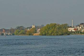

Chiswick Eyot /ˈtʃɪzᵻk ˈeɪt/ is a small, narrow, uninhabited ait (island) in the River Thames. It is on the Tideway by Chiswick, in the Borough of Hounslow, London, England, and has an area of 1.1 hectares (2.7 acres).
The island is beside The Championship Course and is a well-known landmark in the commentary on The Boat Race. A green pole stands on one end of the island, which is used for timings by rowers of that course, at the southwest, church end of the island.[1] Small craft can pass between the island and the Chiswick Mall[n 1] on the Middlesex bank for about two hours at high tide, but the small channel is generally impassable otherwise, and at low tide it is possible to walk across it to the island.[2]
Chiswick Eyot was used during the industrial revolution mostly for the growing of grass and osiers (basket willows, used for basketry, furniture, cart-making, as well as cattle fodder). Much erosion has taken place, and it now becomes fully submerged (excluding trees) at high tide.
The London Borough of Hounslow declared the island a Local Nature Reserve of Greater London in 1993.[3][4]
Prior to 1934 when ownership passed to the local council, Chiswick Eyot was owned by the Ecclesiastical Commissioners.[5]
Chiswick Eyot is one of 43 unbridged tidal islands which can be walked to from the mainland of Great Britain,[5] dating back to the British Iron Age such tidal islands are occasionally associated with being sanctuaries and meeting places;[6] some are named Holy Islands. St. Nicholas Church, Chiswick is 200m west of the island on a slight rise by the river, the tower was built in the 15th century.[7]
See also
Notes and Citations
- Notes
- ↑ Mall in the meaning given in London refers to a scenic street, specifically in the case of Hammersmith's Upper and Lower Mall and Chiswick Mall to a promenade road lined with houses.
- Citations
- ↑ Vesta Rowing Club — Veterans Head/ Pairs Head of the River Race
- ↑ Ordnance Survey map, courtesy of English Heritage Archived April 24, 2012, at the Wayback Machine.
- ↑ "Chiswick Eyot". Local Nature Reserves. Natural England. 1 March 2013. Retrieved 22 January 2014.
- ↑ "Map of Chiswick Eyot". Local Nature Reserves. Natural England. Retrieved 22 January 2014.
- 1 2 "Kew to Wandsworth". Tideway. John Kennett. Archived from the original on 2007-02-07. Retrieved 2009-01-05.
- ↑ No Boat Required – Exploring Tidal Islands, Peter Caton, 2011, Troubador Publishing, ISBN 978-1848767-010
- ↑ St Nicholas Church, Chiswick Grade II* listing Historic England. "Details from listed building database (1189405)". National Heritage List for England.
References
- Cornish, C. J. (1902). The naturalist on the Thames. London: Seeley. p. 68. OCLC 3251979.
External links
| Wikimedia Commons has media related to Chiswick, London Borough of Hounslow. |
| Next island upstream | River Thames | Next island downstream |
| Oliver's Island | Chiswick Eyot | Frog Island |
Coordinates: 51°29′15″N 0°14′45″W / 51.48750°N 0.24583°W