Chilocco, Oklahoma
| Chilocco, Oklahoma | |
|---|---|
| Unincorporated community | |
 Chilocco, Oklahoma | |
| Coordinates: 36°59′20″N 97°04′11″W / 36.98889°N 97.06972°WCoordinates: 36°59′20″N 97°04′11″W / 36.98889°N 97.06972°W | |
| Country | United States |
| State | Oklahoma |
| County | Kay |
| Elevation | 1,152 ft (351 m) |
| Time zone | Central (CST) (UTC-6) |
| • Summer (DST) | CDT (UTC-5) |
| Area code(s) | 580 |
| GNIS feature ID | 1091297[1] |
Chilocco is an unincorporated community in Kay County, Oklahoma, United States.[1] The community is located in northern Kay County, 5.4 miles (8.7 km) south-southwest of Arkansas City, Kansas. Its name came from the Chilocco Indian School, which in turn most likely took its name from the Creek tci lako, which literally meant "big deer" but typically referred to a horse. A post office opened in Chilocco on March 27, 1883.[2]
References
- 1 2 "Chilocco". Geographic Names Information System. United States Geological Survey.
- ↑ Shirk, George H. (1974). Oklahoma Place Names (2 ed.). Norman, Oklahoma: University of Oklahoma Press. p. 50. ISBN 0806111402.
Municipalities and communities of Kay County, Oklahoma, United States | ||
|---|---|---|
| Cities | 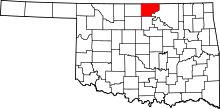 | |
| Towns | ||
| CDP | ||
| Unincorporated communities |
| |
| Ghost towns | ||
| Footnotes | ‡This populated place also has portions in an adjacent county or counties | |
This article is issued from Wikipedia - version of the 10/22/2016. The text is available under the Creative Commons Attribution/Share Alike but additional terms may apply for the media files.