Chikmagalur
| Chikkamagaluru ಚಿಕ್ಕಮಗಳೂರು | |
|---|---|
| town | |
|
Court Road, Chikkamagaluru | |
| Nickname(s): Coffee Town | |
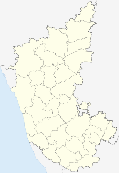 Chikkamagaluru Location in Karnataka, India | |
| Coordinates: 13°18′47″N 75°44′13″E / 13.313°N 75.737°ECoordinates: 13°18′47″N 75°44′13″E / 13.313°N 75.737°E | |
| Country | India |
| State | Karnataka |
| Founded by | King Rukmangada |
| Named for | Mullayanagiri range |
| Government | |
| • Body | Nagar Palika |
| Area | |
| • Total | 30 km2 (10 sq mi) |
| Highest elevation | 1,925 m (6,316 ft) |
| Population (2011)[1] | |
| • Total | 118,496 |
| • Density | 3,900/km2 (10,000/sq mi) |
| Languages | |
| • Official | Kannada |
| Time zone | IST (UTC+5:30) |
| PIN | 577101 - 577102, 577133 |
| Vehicle registration | KA- 18 |
| Website |
www |

.jpg)
Chikkamagaluru is a town located in the Chikkamagaluru district in the Indian state of Karnataka. Located in the foothills of the Mullayanagiri range, the town with its favorable climate and coffee estates attracts tourists from around the state. National Highway 173 (India) passes through the town connecting it with the state capital Bangalore, located 250 kilometres (160 mi) away.
Etymology
Chikkamagaluru takes its name from the Kannada Cikkamagaḷa ūru that translates to "younger daughter's town". It is said to have been given as a dowry to the youngest daughter of Rukmangada, the legendary chief of Sakharayapattana.
Demographics
As of 2011 India census,[2] Chikmagalur had a population of 118,496. Males constitute 51% of the population and females 49%. Chikmagalur has an average literacy rate of 72%, higher than the national average of 59.5%, with male literacy of 80% and female literacy of 73%. 11% of the population is under 6 years of age.[1]
Transport
Chikmagalur is connected to other parts of the state through roads. National Highway 173 (India) passes through the town and forms the main link for buses traveling from North Karnataka to the coastal districts. State Highway 57 (Karnataka) connects between Shimoga and Hassan. A railway line connects Chikmagalur to Kadur. The nearest international airport is at Mangalore.
Geography and Climate
Chikmagalur is situated in the Mallenadu region of Karnataka in the Deccan plateau in the foothills of the Western Ghats. It is situated at an elevation of 1,090 metres (3,580 ft) above mean sea level. The Yagachi River has its source near the town and flows in the south-easterly direction before uniting with the Kaveri river. Chikmagalur generally has a moderate to cool climate. The temperature of the city varies from 11-20 °C during winter to 25-32 °C during summer.
Tourism
Chikkamagaluru attracts many tourists especially from India due its scenic locations and nearby hill stations such as Kudremukh, Mullayanagiri, Kalasa, Koppa, Sringeri, Balehonnur and Mudigere.
| Climate data for Chikmagalur | |||||||||||||
|---|---|---|---|---|---|---|---|---|---|---|---|---|---|
| Month | Jan | Feb | Mar | Apr | May | Jun | Jul | Aug | Sep | Oct | Nov | Dec | Year |
| Average high °C (°F) | 27 (81) |
29 (84) |
31.6 (88.9) |
31.5 (88.7) |
29.8 (85.6) |
25.2 (77.4) |
22.6 (72.7) |
23.2 (73.8) |
24.3 (75.7) |
26.2 (79.2) |
25.8 (78.4) |
25.5 (77.9) |
26.81 (80.28) |
| Average low °C (°F) | 13.7 (56.7) |
15.2 (59.4) |
17.2 (63) |
18.1 (64.6) |
19.1 (66.4) |
18.4 (65.1) |
18.1 (64.6) |
18 (64) |
17.6 (63.7) |
17 (63) |
15.9 (60.6) |
14.1 (57.4) |
16.87 (62.38) |
| Average rainfall mm (inches) | 2 (0.08) |
4 (0.16) |
13 (0.51) |
61 (2.4) |
112 (4.41) |
127 (5) |
226 (8.9) |
132 (5.2) |
104 (4.09) |
154 (6.06) |
59 (2.32) |
13 (0.51) |
1,007 (39.64) |
| Source: [3] | |||||||||||||
References
- 1 2 "Census 2011". The Registrar General & Census Commissioner, India. Retrieved 24 July 2014.
- ↑ "Census of India 2001: Data from the 2001 Census, including cities, villages and towns (Provisional)". Census Commission of India. Archived from the original on 2004-06-16. Retrieved 2008-11-01.
- ↑ "Climate data". en.climate-data.org. August 2015. Retrieved 27 June 2013.
External links
| Wikimedia Commons has media related to Chikmagalur. |
 Chikmagalur travel guide from Wikivoyage
- Chickmagalur City Municipal Council Website