Chiautla de Tapia
Coordinates: 18°17′57″N 98°36′10″W / 18.29917°N 98.60278°W
| Chiautla de Tapia | |
|---|---|
| Municipality and town | |
| Country |
|
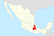
| State | Puebla |
| Time zone | Central Standard Time (UTC-6) |
| • Summer (DST) | Central Daylight Time (UTC-5) |
Chiautla de Tapia is a city and municipality in La Mixteca region of Puebla in south-eastern Mexico.[1] The municipality of Chiautla has a surface area of 685.05 km² which makes it the largest municipality in the state of Puebla. The BUAP has a Regional Section there.
Notable figures
References
- ↑ "-". Enciclopedia de los Municipios de México. Instituto Nacional para el Federalismo y el Desarrollo Municipal. Archived from the original on April 5, 2007. Retrieved January 4, 2010.
External links
This article is issued from Wikipedia - version of the 11/21/2016. The text is available under the Creative Commons Attribution/Share Alike but additional terms may apply for the media files.