Cherry Burton
| Cherry Burton | |
 Cherry Burton |
|
| Population | 1,392 (2011 census)[1] |
|---|---|
| OS grid reference | SE989420 |
| – London | 165 mi (266 km) S |
| Civil parish | Cherry Burton |
| Unitary authority | East Riding of Yorkshire |
| Ceremonial county | East Riding of Yorkshire |
| Region | Yorkshire and the Humber |
| Country | England |
| Sovereign state | United Kingdom |
| Post town | BEVERLEY |
| Postcode district | HU17 |
| Dialling code | 01964 |
| Police | Humberside |
| Fire | Humberside |
| Ambulance | Yorkshire |
| EU Parliament | Yorkshire and the Humber |
| UK Parliament | Beverley and Holderness |
Coordinates: 53°51′54″N 0°29′48″W / 53.864926°N 0.496646°W
Cherry Burton is a village and civil parish in the East Riding of Yorkshire, England. It is situated approximately 3 miles (5 km) north-west of the market town of Beverley on the eastern edge of the Yorkshire Wolds and lies to the west of the B1248 road.
.jpg)
The civil parish is formed by the village of Cherry Burton and the hamlets of Gardham and High Gardham. According to the 2011 UK Census, Cherry Burton parish had a population of 1,392,[1] a reduction on the 2001 UK Census figure of 1,473.[2]
The village has a Costcutter shop which also acts as a post office and a village hall which holds live musical events and hosts an annual local pantomime. The village public house, the Bay Horse, holds events each week.
Sports in the village includes cricket, football, tennis, and rounders. Clubs for cricket and football have junior sections. Just outside the village is a golf course and caravan park.
The village is one of the few villages in the UK awarded with Fairtrade Village status for promoting fairtrade and local produce. It gained this status on 22 July 2003 and was the second village to do so.[3][4]
Cherry Burton was served by Cherry Burton railway station on the York to Beverley Line between 1865 and 1959.[5]
In September 2015, work began in the village on replacing the older sodium based street lighting with newer LED units. The estimated completion date was put at between 2016 and 2017.[6]
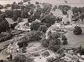 Aerial Photo Cherry Burton circa 1960
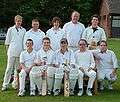 Cherry Burton Cricket Club team photo, 15 May 2008
 A winter day in Cherry Burton
References
- 1 2 "Key Figures for 2011 Census: Key Statistics: Area: Cherry Burton CP (Parish)". Neighbourhood Statistics. Office for National Statistics. Retrieved 3 February 2013.
- ↑ "2001 Census: Key Statistics: Parish Headcounts: Area: Cherry Burton CP (Parish)". Neighbourhood Statistics. Office for National Statistics. Retrieved 15 May 2008.
- ↑ "Fairtrade - Towns List". Fairtrade Foundation. Archived from the original on 1 February 2010. Retrieved 25 July 2008.
- ↑ "Welcome to the Cherry Burton Fairtrade and Local Produce Project". Cherry Burton Fairtrade and Local Produce Project. Retrieved 19 August 2009.
- ↑ Butt, R. V. J. (1995). The Directory of Railway Stations: details every public and private passenger station, halt, platform and stopping place, past and present (1st ed.). Sparkford: Patrick Stephens Ltd. ISBN 1-8526-0508-1. OCLC 60251199.
- ↑ "Street light replacements". East Riding of Yorkshire Council. Retrieved 17 October 2015.
- Gazetteer — A–Z of Towns Villages and Hamlets. East Riding of Yorkshire Council. 2006. p. 4.
External links
 Media related to Cherry Burton at Wikimedia Commons
- Cherry Burton in the Domesday Book