Cheltenham, New South Wales
| Cheltenham Sydney, New South Wales | |||||||||||||
|---|---|---|---|---|---|---|---|---|---|---|---|---|---|
 House opposite Cheltenham Station | |||||||||||||
| Population | 2,067 (2011 census)[1] | ||||||||||||
| Postcode(s) | 2119 | ||||||||||||
| Location | 21 km (13 mi) NW of Sydney CBD | ||||||||||||
| LGA(s) | Hornsby Shire | ||||||||||||
| Region | Northern Suburbs | ||||||||||||
| State electorate(s) | Epping | ||||||||||||
| Federal Division(s) | Berowra | ||||||||||||
| |||||||||||||
Cheltenham is a suburb of Sydney, in the state of New South Wales, Australia. Cheltenham is 21 kilometres north-west of the Sydney central business district in the local government area of Hornsby Shire. Cheltenham is considered to be part of the Northern Suburbs.
This residential suburb has a distinctive English atmosphere, with a number of 19th Century mansions on tree-lined streets. Cheltenham shares its postcode of 2119 with Beecroft and has sometimes been viewed as simply part of that suburb. Most residents of Cheltenham see themselves as distinct from Beecroft, although local issues are addressed together in the Beecroft Cheltenham Civic Trust.
History
Cheltenham takes its name from a house built by William Chorley, a Sydney tailor and men’s outfitter, who acquired the land when it was released from the Field of Mars Reserve. He named the house after his birthplace of Cheltenham, Gloucestershire, England. Chorley asked the government to build a station here and to name it after his property when it opened in 1898. Sutherland Road was named for John Sutherland, Minister for Public Works from 1887to 1889.[2]
Demographics
According to the 2011 census, there were 2,067 residents in Cheltenham. 70% or residents were born in Australia; the most common ancestries in Cheltenham were English 26.4%, Australian 23.0%, Chinese 9.9%, Irish 8.4% and Scottish 8.0%. The median age was 43 years, six years older than the national median of 37. Children aged under 15 made up 18.5% of the population and people aged 65 and over made up 15.5% of the population. The median weekly household income in Cheltenham was $2,568, more than double the national median weekly income of $1,234. The most common religious affiliation was "No Religion".[1]
Transport
Cheltenham railway station is on the on North Shore, Northern & Western Line of the Sydney Trains network. It is one of the few stations with no surrounding business district, due to William Chorley placing covenants on the surrounding land.
The M2 Hills Motorway runs along the southern border of the suburb. For many years, Sutherland Road ran through both Beecroft and Cheltenham, and acted as a short cut between Beecroft Road and Epping Road. This road ran to the east of the Railway line and, during peak hour, was quite busy.With the opening of the M2 Hills Motorway in 1997, Sutherland Road was closed at the Devlins Creek bridge - where the M2 enters a tunnel under North Epping. The result of this closure is that the areas east of the railway line are now very quiet and the house values have benefitted.
On the day of the 2011 census, 23.4% of employed people travelled to work on public transport and 54.8% by car (either as driver or as passenger).[1]
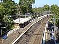 Cheltenham station from the bridge on Cheltenham Road
 Devlins Creek, in flood under the M2, looking to Sutherland Road
Schools
Cheltenham Girls' High School, a government school is located along Beecroft Road and The Promenade. Beecroft Public School and Arden Anglican School are primary schools in nearby Beecroft.
Commercial area
From its early days, Cheltenham was almost exclusively a residential suburb with no shopping area developed at all in its planning. Residents of Cheltenham often shop in Beecroft, Pennant Hills or Epping. The nearest shopping mall is in Carlingford.
Ahimsa
Ahimsa (an Indian word meaning non-violence) is the name of a bush retreat located in Cobran Road. It was originally the home of the environmentalist Marie Byles, who died in the house in 1979. It can be accessed at the rear of Day Road and Cobran Road (both roads are cul-de-sacs). The site is administered by the National Trust of Australia. The house is leased privately but the bush area is open to the public within certain restrictions.[3]
References
- 1 2 3 Australian Bureau of Statistics (31 October 2012). "Cheltenham (State Suburb)". 2011 Census QuickStats. Retrieved 6 November 2012.
- ↑ The Book of Sydney Suburbs, Compiled by Frances Pollen, Angus & Robertson Publishers, 1990, Published in Australia ISBN 0-207-14495-8
- ↑ National Trust Site Archived 13 November 2012 at the Wayback Machine.
- Beecroft Cheltenham Civic Trust webpage
- Beecroft Cheltenham History Group Inc (1995). Beecroft and Cheltenham : The Shaping of a Sydney Community to 1914. ISBN 0-646-24286-5. (295 pages)
External links
| Wikimedia Commons has media related to Cheltenham, New South Wales. |
- Joan Rowland (2008). "Cheltenham". Dictionary of Sydney. Retrieved 26 September 2015. [CC-By-SA]
- Cheltenham suburb profile @ domain.com.au
Coordinates: 33°45′30″S 151°04′32″E / 33.75839°S 151.07569°E