Charlestown Township, Portage County, Ohio
| Charlestown Township | |
|---|---|
| Civil township | |
|
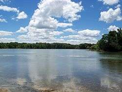
The Michael J Kirwan Reservoir in West Branch State Park | |
 Location within Portage County | |
| Coordinates: 41°9′26″N 81°9′28″W / 41.15722°N 81.15778°WCoordinates: 41°9′26″N 81°9′28″W / 41.15722°N 81.15778°W | |
| Country | United States |
| State | Ohio |
| County | Portage |
| Area | |
| • Total | 23.1 sq mi (59.9 km2) |
| • Land | 20.3 sq mi (52.7 km2) |
| • Water | 2.8 sq mi (7.3 km2) |
| Elevation[1] | 1,099 ft (335 m) |
| Population (2000) | |
| • Total | 2,003 |
| • Density | 98.5/sq mi (38.0/km2) |
| Time zone | Eastern (EST) (UTC-5) |
| • Summer (DST) | EDT (UTC-4) |
| ZIP code | 44266 |
| Area code(s) | 330, 234 |
| FIPS code | 39-13610[2] |
| GNIS feature ID | 1086824[1] |
Charlestown Township is one of the eighteen townships of Portage County, Ohio, United States. The 2000 census found 2,003 people in the township.[3]
Geography
Located in the center of the county, it borders the following townships:
- Freedom Township - north
- Windham Township - northeast corner
- Paris Township - east
- Palmyra Township - southeast corner
- Edinburg Township - south
- Rootstown Township - southwest corner
- Ravenna Township - west
- Shalersville Township - northwest corner
No municipalities are located in Charlestown Township.
Formed from the Connecticut Western Reserve, Charlestown Township covers an area of 23.1 sq mi (60 km2). Much of the township, however, is occupied by state and federal installations. Camp Ravenna Joint Military Training Center, created in 1941, covers most of the northern half of the township, while West Branch State Park and the Michael J. Kirwan reservoir, opened in 1966, occupies much of the southern half.
Name and history
Charlestown Township was organized in 1814.[4] It is the only Charlestown Township statewide.[5] A post office called Charlestown was established in 1820, and remained in operation until 1904.[6]
Government
The township is governed by a three-member board of trustees, who are elected in November of odd-numbered years to a four-year term beginning on the following January 1. Two are elected in the year after the presidential election and one is elected in the year before it. There is also an elected township fiscal officer,[7] who serves a four-year term beginning on April 1 of the year after the election, which is held in November of the year before the presidential election. Vacancies in the fiscal officership or on the board of trustees are filled by the remaining trustees.
References
- 1 2 "US Board on Geographic Names". United States Geological Survey. 2007-10-25. Retrieved 2008-01-31.
- ↑ "American FactFinder". United States Census Bureau. Archived from the original on 2013-09-11. Retrieved 2008-01-31.
- ↑ Portage County, Ohio — Population by Places Estimates Ohio State University, 2007. Accessed 15 May 2007.
- ↑ History of Portage County, Ohio: Containing a History of the County, Its Townships, Towns, Villages, Schools, Churches, Industries, Etc. Warner, Beers & Company. 1885. p. 415.
- ↑ "Detailed map of Ohio" (PDF). United States Census Bureau. 2000. Retrieved 2007-02-16.
- ↑ "Portage County". Jim Forte Postal History. Archived from the original on 4 March 2016. Retrieved 13 January 2016.
- ↑ §503.24, §505.01, and §507.01 of the Ohio Revised Code. Accessed 4/30/2009.
External links
Municipalities and communities of Portage County, Ohio, United States | ||
|---|---|---|
| Cities | 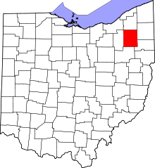 | |
| Villages | ||
| Townships | ||
| CDPs | ||
| Unincorporated communities | ||
| Former settlements | ||
| Footnotes | ‡This populated place also has portions in an adjacent county or counties | |