Charles River Reservation Parkways
|
Charles River Reservation Parkways | |
|
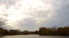
View along the Charles showing the Henderson Boathouse. Soldiers Field Road to the left Greenough Blvd to the right. | |
   | |
| Location | Boston, Newton, Watertown, and Weston, Massachusetts |
|---|---|
| Coordinates | 42°21′31.7″N 71°9′40.9″W / 42.358806°N 71.161361°WCoordinates: 42°21′31.7″N 71°9′40.9″W / 42.358806°N 71.161361°W |
| Area | 65 acres (26 ha) |
| Built | 1895 |
| Architect |
Charles Eliot Olmsted Brothers |
| MPS | Metropolitan Park System of Greater Boston MPS |
| NRHP Reference # | 05001530[1] |
| Added to NRHP | January 18, 2006 |

The Charles River Reservation Parkways are parkways that run along either side of the Charles River in eastern Massachusetts. The roads are contained within the Charles River Reservation and the Upper Charles River Reservation, and fall within a number of communities in the greater Boston metropolitan area. The Charles River parks extend from the Charles River Dam, where the Charles empties into Boston Harbor, to Riverdale Park in the West Roxbury neighborhood of Boston. Most of the roadways within the parks are listed on the National Register of Historic Places as a unit, although Storrow Drive and Memorial Drive are listed as part of the Charles River Basin Historic District.
The other roadways, listed in 2006, extend from Harvard Square to Newton Upper Falls. The roads on the river banks were improved at the beginning of the 20th century to provide a continuous route through the park.
Eastern parkways
The eastern parkways are within the Charles River Reservation, extending from Harvard Square to the vicinity of Watertown Square in Watertown and Newton.
- Western Avenue/Arsenal Street, a short stretch between Soldiers Field Rd and Greenough Blvd, including a bridge across the river
- Charles River Road, on the north bank in Watertown
- Greenough Boulevard, the north bank from the end of Memorial Drive in Cambridge to Arsenal Street in Watertown
- Leo Birmingham Parkway, a short stretch farther from the river on the south bank, joining Soldiers Field Road at each end
- Nonantum Road, on the south bank from the end of Soldiers Field Road into Newton
- North Beacon Street, a short stretch connecting Greenough Blvd with Charles River Road
- Soldiers Field Road, from the end of Storrow Drive through Allston and Brighton to the North Beacon Street Bridge, where it meets Nonantum Road
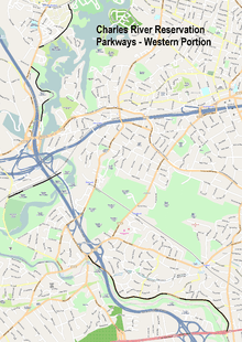
Western parkways
The western parkways are within the Upper Charles River Reservation. They comprise several discontiguous segments in Waltham, Weston, and Newton. The stretch of the Charles they abut are between Sawyer Road in Waltham and Route 9 near its interchange with I-95.[2]
- Norumbega Road, between South Street and Route 30 in Waltham
- Quinobequin Road, between Route 16 and Route 9 in Newton
- Recreation Road, between I-95 and Park Street in Weston
See also
- National Register of Historic Places listings in Cambridge, Massachusetts
- National Register of Historic Places listings in Middlesex County, Massachusetts
- National Register of Historic Places listings in Newton, Massachusetts
- National Register of Historic Places listings in Waltham, Massachusetts
- National Register of Historic Places listings in Weston, Massachusetts
- National Register of Historic Places listings in northern Boston, Massachusetts
References
- ↑ National Park Service (2009-03-13). "National Register Information System". National Register of Historic Places. National Park Service.
- ↑ "NRHP nomination for Charles River Reservation Parkways". Commonwealth of Massachusetts. Retrieved 2014-01-23.
| Topics |  | ||||||||||||||||||||||||||||||
|---|---|---|---|---|---|---|---|---|---|---|---|---|---|---|---|---|---|---|---|---|---|---|---|---|---|---|---|---|---|---|---|
| Lists by county | |||||||||||||||||||||||||||||||
| Lists by city |
| ||||||||||||||||||||||||||||||
| Other lists | |||||||||||||||||||||||||||||||
| |||||||||||||||||||||||||||||||