Chila mountain range
| Chila mountain range | |
|---|---|
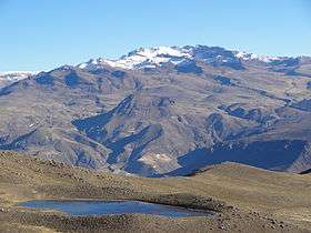 Mismi behind the lake Limaquta | |
| Highest point | |
| Peak | Chila |
| Elevation | 5,654 m (18,550 ft) |
| Dimensions | |
| Length | 80 km (50 mi) N-S |
| Geography | |
| Country | Peru |
| State/Province | Arequipa Region |
| Parent range | Andes |
The Chila mountain range lies in the Arequipa Region in the Andes of Peru. It extends between 15°02' and 15°26'S and 71°43' and 72°37'W for about 80 km.[1] The range is located in the provinces of Castilla and Caylloma.
Mountains
The highest mountain in the range is Chila at 5,654 m (18,550 ft). Other mountains are listed below:[2][3][4][5]
|
|
References
- ↑ usgs.gov USGS, Peruvian Cordilleras
- ↑ Taken from Mountaineering in the Andes by Jill Neate RGS-IBG Expedition Advisory Centre, 2nd edition, May 1994
- ↑ lib.utexas.edu Map of the area
- ↑ allthemountains.com
- ↑ escale.minedu.gob.pe - UGEL map of the Caylloma Province 1 (Arequipa Region)
This article is issued from Wikipedia - version of the 9/18/2016. The text is available under the Creative Commons Attribution/Share Alike but additional terms may apply for the media files.