Central Idaho
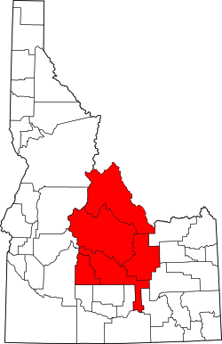
Map of Central Idaho (highlighted in red)

Borah Peak, Idaho, looking east.
Central Idaho is a geographical term for the region located northeast of Boise and southeast of Lewiston in the U.S. state of Idaho . It is dominated by federal lands administered by the United States Forest Service and the Bureau of Land Management. Idaho's tallest mountain, Borah Peak, is located in this region. A large part of the Sawtooth National Recreation Area is within Central Idaho.
The counties of Blaine, Butte, Camas, Custer, and Lemhi are included in the region.
Cities
External links
Coordinates: 44°24′N 114°05′W / 44.400°N 114.083°W
This article is issued from Wikipedia - version of the 11/18/2016. The text is available under the Creative Commons Attribution/Share Alike but additional terms may apply for the media files.