Center Ossipee, New Hampshire
| Center Ossipee, New Hampshire | |
|---|---|
| Census-designated place | |
 Center Ossipee  Center Ossipee | |
| Coordinates: 43°45′18″N 71°9′14″W / 43.75500°N 71.15389°WCoordinates: 43°45′18″N 71°9′14″W / 43.75500°N 71.15389°W | |
| Country | United States |
| State | New Hampshire |
| County | Carroll |
| Town | Ossipee |
| Area | |
| • Total | 1.0 sq mi (2.5 km2) |
| • Land | 1.0 sq mi (2.5 km2) |
| • Water | 0.0 sq mi (0.0 km2) |
| Elevation | 530 ft (160 m) |
| Population (2010) | |
| • Total | 561 |
| • Density | 580/sq mi (220/km2) |
| Time zone | Eastern (EST) (UTC-5) |
| • Summer (DST) | EDT (UTC-4) |
| ZIP code | 03814 |
| Area code(s) | 603 |
| FIPS code | 33-10820 |
| GNIS feature ID | 0866082 |
Center Ossipee is a census-designated place in the town of Ossipee in Carroll County, New Hampshire. The population was 561 at the 2010 census.[1] It is one of two major villages in the town, the other being Ossipee Corner (shown simply as "Ossipee" on topographic maps).
New Hampshire Route 16 and Route 25 bypass the village to the east. Route 16 connects Rochester to the south with Conway to the north, while Route 25 connects Portland, Maine to the east with Plymouth, New Hampshire to the west. Center Ossipee has a separate ZIP code (03814) from other portions of the town of Ossipee.
References
- ↑ United States Census Bureau, American FactFinder, 2010 Census figures. Retrieved March 23, 2011.
Municipalities and communities of Carroll County, New Hampshire, United States | ||
|---|---|---|
| Towns | 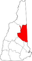 | |
| Township | ||
| CDPs | ||
| Other villages | ||
This article is issued from Wikipedia - version of the 7/10/2016. The text is available under the Creative Commons Attribution/Share Alike but additional terms may apply for the media files.