List of regions of Nunavut

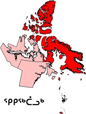
The regions of Nunavut serve as census divisions, although Statistics Canada has tended to use the names "Baffin Region" for Qikiqtaaluk Region and "Keewatin Region" for Kivalliq Region. Though the regions have no autonomous governments, Nunavut's territorial government services are highly decentralized on a regional basis. The Qikiqtaaluk or Baffin Region is the largest region in Canada, while the Kitikmeot Region is the second least densely populated.
It is a misconception that Nunavut is made up of some of the former regions of the Northwest Territories, separated in their entirety. This is not the case; the dividing line did not follow region boundaries, although boundaries have been subsequently finessed so that three former NWT regions collectively constitute Nunavut.
The regional divisions are distinct from the district system of dividing the Northwest Territories that dated to 1876 and was abolished when Nunavut was created. Nunavut encompasses the entirety of the District of Keewatin (which had differing boundaries from the Keewatin/Kivalliq regions), the majority of the District of Franklin and a small portion of the District of Mackenzie.
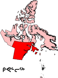
| Region and Postal Code | Kitikmeot Region X0B | Kivalliq Region X0C | Qikiqtaaluk Region X0A |
|---|---|---|---|
| (replaced "Kitikmeot Region, NWT") | (replaced "Keewatin Region, NWT") | (replaced "Baffin Region, NWT") | |
| Census division name | Kitikmeot Region[1] | Keewatin Region[2] | Baffin Region[3] |
| Regional seat | Cambridge Bay | Rankin Inlet | Iqaluit |
| Area | 443,277.34 square kilometres (171,150.34 sq mi) | 444,621.10 square kilometres (171,669.17 sq mi) | 989,889.18 square kilometres (382,198.35 sq mi) |
| Population, 2011 (2006) | 6,010 (5,361) | 8,955 (8,348) | 16,939 (15,765) |
| Population change (2011–2006) |
+12.1% | +7.3% | +7.4% |
| Density | 0.014/km2 (0.036/sq mi) | 0.020/km2 (0.052/sq mi) | 0.017/km2 (0.044/sq mi) |
| Map | 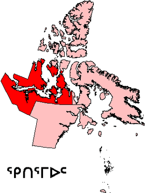 |
 |
 |
See also
References
- ↑ "Census Profile - Kitikmeot 2011". Statistics Canada. Government of Canada. Retrieved 28 May 2016.
- ↑ "Census Profile - Keewatin 2011". Statistics Canada. Government of Canada. Retrieved 28 May 2016.
- ↑ "Census Profile - Baffin 2011". Statistics Canada. Government of Canada. Retrieved 28 May 2016.
| Provinces | |
|---|---|
| Territories | |
| |
| Provinces |
|
|---|---|
| Territories |
|
| |