Cedar Point, North Carolina
| Cedar Point, North Carolina | ||
|---|---|---|
| Town | ||
| ||
 Location of Cedar Point, North Carolina | ||
| Coordinates: 34°41′8″N 77°4′57″W / 34.68556°N 77.08250°WCoordinates: 34°41′8″N 77°4′57″W / 34.68556°N 77.08250°W | ||
| Country | United States | |
| State | North Carolina | |
| County | Carteret | |
| Area | ||
| • Total | 2.2 sq mi (5.7 km2) | |
| • Land | 2.2 sq mi (5.7 km2) | |
| • Water | 0.0 sq mi (0.0 km2) | |
| Elevation | 20 ft (6 m) | |
| Population (2010) | ||
| • Total | 1,279 | |
| • Density | 582/sq mi (224.6/km2) | |
| Time zone | Eastern (EST) (UTC-5) | |
| • Summer (DST) | EDT (UTC-4) | |
| FIPS code | 37-11340[1] | |
| GNIS feature ID | 1010133[2] | |
| Website |
www | |

Cedar Point is a town in Carteret County, North Carolina, United States. The population was 1,297 in 2010.[3]
Geography
Cedar Point is located at the western end of Carteret County at 34°41′8″N 77°4′57″W / 34.68556°N 77.08250°W (34.685574, -77.082371).[4] It is bordered to the north by the town of Peletier and to the east by the town of Cape Carteret. To the south is Bogue Sound, crossed by the B. Cameron Langston Bridge to Emerald Isle, and to the west is the tidal White Oak River, crossed by North Carolina Highway 24 to the town of Swansboro in Onslow County.
According to the United States Census Bureau, the town of Cedar Point has a total area of 2.2 square miles (5.7 km2), of which 0.004 square miles (0.01 km2), or 0.23%, is water.[3]
Demographics
| Historical population | |||
|---|---|---|---|
| Census | Pop. | %± | |
| 1990 | 628 | — | |
| 2000 | 929 | 47.9% | |
| 2010 | 1,279 | 37.7% | |
| Est. 2015 | 1,304 | [5] | 2.0% |
As of the census[1] of 2000, there were 929 people, 438 households, and 278 families residing in the town. The population density was 381.8 people per square mile (147.6/km²). There were 893 housing units at an average density of 367.0 per square mile (141.9/km²). The racial makeup of the town was 98.92% White, 0.32% African American, 0.11% Native American, 0.32% Asian, 0.11% Pacific Islander, and 0.22% from two or more races. Hispanic or Latino of any race were 0.86% of the population.
There were 438 households out of which 21.0% had children under the age of 18 living with them, 52.3% were married couples living together, 5.9% had a female householder with no husband present, and 36.5% were non-families. 30.6% of all households were made up of individuals and 15.8% had someone living alone who was 65 years of age or older. The average household size was 2.12 and the average family size was 2.61.
In the town the population was spread out with 17.7% under the age of 18, 5.8% from 18 to 24, 23.5% from 25 to 44, 30.8% from 45 to 64, and 22.3% who were 65 years of age or older. The median age was 47 years. For every 100 females there were 98.9 males. For every 100 females age 18 and over, there were 95.2 males.
The median income for a household in the town was $40,655, and the median income for a family was $46,818. Males had a median income of $30,000 versus $30,104 for females. The per capita income for the town was $25,457. About 11.1% of families and 10.9% of the population were below the poverty line, including 13.0% of those under age 18 and 9.5% of those age 65 or over.
References
- 1 2 "American FactFinder". United States Census Bureau. Archived from the original on 2013-09-11. Retrieved 2008-01-31.
- ↑ "US Board on Geographic Names". United States Geological Survey. 2007-10-25. Retrieved 2008-01-31.
- 1 2 "Geographic Identifiers: 2010 Demographic Profile Data (G001): Cedar Point town, North Carolina". U.S. Census Bureau, American Factfinder. Retrieved December 23, 2014.
- ↑ "US Gazetteer files: 2010, 2000, and 1990". United States Census Bureau. 2011-02-12. Retrieved 2011-04-23.
- ↑ "Annual Estimates of the Resident Population for Incorporated Places: April 1, 2010 to July 1, 2015". Retrieved July 2, 2016.
- ↑ "Census of Population and Housing". Census.gov. Archived from the original on May 11, 2015. Retrieved June 4, 2015.
External links
Municipalities and communities of Carteret County, North Carolina, United States | ||
|---|---|---|
| Towns | 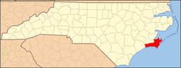 | |
| CDPs | ||
| Other unincorporated communities | ||
| Ghost towns | ||