Cattus Island Park
| Cooper Environmental Center | |
|---|---|
 | |
| Location |
1170 Cattus Island Blvd. Toms River, New Jersey, USA |
| Coordinates | 39°58′40″N 74°08′01″W / 39.9777°N 74.1337°WCoordinates: 39°58′40″N 74°08′01″W / 39.9777°N 74.1337°W |
| Area | 530 acres (210 ha) |
| Website | Cattus Island Park |
Cattus Island Park, also known as Cattus Island is a 530 acres (2 km2) passive recreational park located in Toms River, New Jersey. Cattus Island is a park of the Ocean County Department of Parks and Recreation. Cattus Island is home to the Cooper Environmental Center, an educational center which displays collections of local wildlife including snakes, reptiles and aquatic animals. The center also provides educational programs and presentations to the public and organized groups.
History
The first European explorer to set foot on what became Ocean County soil was Captain Cornelius Hendrickson, who in 1615 explored the New Jersey coast in the Onrust (or Restless) between the latitudes 38 and 40 degrees. He sailed down Barnegat Bay and located the 300 acres (1.2 km²) Cattus Island.[1] William Dockwra, Secretary and Registrar for the Board of Proprietors in England, bought Cattus Island.[2] The "island" has remained a single parcel since 1690 when the Board of Proprietors of the Province of East Jersey divided this coastal region.
In 1758 Joseph Page purchased Cattus Island. On Page's Island farm, sheep, flax and corn crops were raised.[3] The Page family first settled the island in 1763. Timothy Page, born on the island during that year, served in the local militia during the American Revolution. During the American Revolutionary War, local residents used the area to bring captured British vessels into the Toms River in order to offload their cargoes. Homesteaders also used the island for farming. Timothy Page was likely a privateer, essentially a pirate licensed by the Continental Congress. During the war, British ships were lured into Barnegat Bay through the Cranberry Inlet, only to be attacked and their cargo was sold for profit. Cranberry Inlet, an opening to the Atlantic near present-day Ortley Beach, existed between 1750 and 1812. It was opened and closed by strong storms.
After the death of Timothy Page, the family house burned down, and the property was sold to Lewis Applegate. He moved there in 1842 and developed the southeastern section of the island, now named for him. He built a sawmill and a port for lumber boats. The island was sold again in 1867 and was slated to be developed as a resort, but the 1873 depression canceled the project.
John V. A. Cattus, a New York importer and Olympic class athlete, bought the land and developed it as a retreat in 1895. Hunting and fishing were the favorite sports of Cattus and his friends. He built a hunting lodge on the island, along with a farm, boat house and boat dock. When Cattus died, the land was sold in 1964 by his sons to developers.
In the 1970s, new state laws passed limiting development in wetlands and along the coast. In 1973 Ocean County purchased this 497 acres (2 km²) land. The property was acquired with county tax money and state "Green Acres" funds. In 1980 the park opened to the public with the county's first Environmental Center.[4]
In 2012, Hurricane Sandy struck and the park sustained significant damage. Thousands of hours of labor were required to remove downed trees and debris that littered the park.
Park ecosystems
One ecosystem, located in Cattus Island Park, is a maritime upland pine/oak forest, which consists mostly of oak trees and pine trees, such as the pitch pines and the short leaf pines. Even though Cattus Island Park is a maritime forest, within its pine/oak forest, one can find many of the same shrubs and animal species that are native to the Pine Barrens.
Cattus Island Park also contains freshwater wetlands. These wetlands are dominated by hardwood trees such as Red Maple or Swamp Maple, Sour Gum or Tupelo and a wide variety of others. There are a few small stands of living Atlantic White Cedar located in some of the wetland areas. However, in this area, large stands of dead Atlantic white cedar also exist. They have been standing dead since the 1930s. Prior to the 1930s, the northern part of the Barnegat Bay, where Cattus Island is located, was mainly fresh water. After the Point Pleasant Canal was constructed and the Manasquan inlet improved, saltwater from the ocean infiltrated into the Northern portion of the bay. As a result, the Atlantic white cedar, which is an obligate freshwater species, was killed.
Another ecosystem that thrives within the park is a vast track of salt marsh, which contains several species of Spartina grasses. It is from these salt marshes that Cattus Island gets part of its name. Several times a year, the marshes flood, as a result of snowmelt, spring/summer storms or high tides. During the floods, the second bit of upland is completely inaccessible. Hence, it becomes an 'island'.[5]
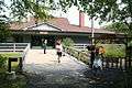
Cooper Environmental Center
The Cooper Environmental Center is an educational facility and resource for conservation and education, featuring a 5,000 square foot (500 m²) building with an eighty-seat meeting room, interactive exhibit area, and live native reptiles and fish. As a result of Hurricane Sandy, the Cooper Environmental Center remains closed for repairs; with an anticipated reopening in 2016.


References
External links
- Cattus Island History - NY/NJ/CT Botany Website
- Cattus Island Park
- Photo Gallery
- http://facebook.com/Cattus.Island.County.Park