Catskill Mountains
| Catskill Mountains | |
|---|---|
|
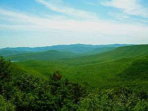
Slide Mountain and the peaks around it as seen from Twin Mountain in the northern Catskills | |
| Highest point | |
| Peak | Slide Mountain (S of Shandaken) |
| Elevation | 4,180 ft (1,270 m) |
| Coordinates | 41°59′55″N 74°23′11″W / 41.99861°N 74.38639°WCoordinates: 41°59′55″N 74°23′11″W / 41.99861°N 74.38639°W |
| Dimensions | |
| Length | 111 mi (179 km) N/S |
| Width | 102 mi (164 km) E/W |
| Area | 15,259 km2 (5,892 sq mi) |
| Geography | |
 Map of the main regions of the northeast Appalachians, with the Catskills as "C". | |
| Country | United States |
| State | New York |
| Region | Hudson Valley |
| Counties | |
| Communities | |
| Borders on | |
| Geology | |
| Age of rock | Devonian and Mississippian |
| Type of rock | Sedimentary |
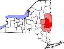
The Catskill Mountains, also known as the Catskills, are a large area in the southeastern portion of the U.S. state of New York. They are located approximately 100 miles (160 km) north-northwest of New York City and 40 miles (60 km) southwest of Albany, starting just west of the Hudson River. The Catskills occupy much or all of five counties (Delaware, Greene, Schoharie, Sullivan, and Ulster), with some areas falling into the boundaries of southwestern Albany, eastern Broome, northwestern Orange, and southern Otsego counties. Foothills are also found in southeastern Chenango, southern Montgomery, northern Otsego, and western Schenectady counties. As a cultural and geographic region, the Catskills are generally defined as those areas close to or within the borders of the Catskill Park, a 700,000-acre (2,800 km2) forest preserve protected from many forms of development under New York state law.
Geologically, the Catskills are a mature dissected plateau, a once-flat region subsequently uplifted and eroded into sharp relief by watercourses. The Catskills form the northeastern end of, and highest-elevation portion of, the Allegheny Plateau (also known as the Appalachian Plateau).[1][2] Although the Catskills are sometimes compared with the Adirondack Mountains further north, the two mountain ranges are not geologically related, as the Adirondacks are a continuation of the Canadian Shield. Similarly, the Shawangunk Ridge, which forms the southeastern edge of the Catskills, is part of the geologically distinct Ridge-and-Valley province, and is a continuation of the same ridge known as Kittatinny Mountain in New Jersey and Blue Mountain in Pennsylvania.
Climatically, the Catskills lie within the Allegheny Highlands forests ecoregion.
The Catskills are well known in American culture, both as the setting for many 19th-century Hudson River School paintings and as the favored destination for urban vacationers from New York City in the mid-20th century. The region's many large resorts gave countless young stand-up comedians an opportunity to hone their craft. In addition, the Catskills have long been a haven for artists, musicians, and writers, especially in and around the towns of Phoenicia and Woodstock, New York.
Name
.jpg)
Nicolaes Visscher I's 1656 map of New Netherland located the Landt van Kats Kill at the mouth of Catskill creek. The region to the south is identified as Hooge Landt van Esopus (High Lands of the Esopus), a reference to a local band northern Lenape Native Americans who inhabited the banks of the Hudson and hunted in the highlands along the Esopus Creek.[3]
While the meaning of the name ("cat creek" in Dutch) and the namer (early Dutch explorers) are settled matters, exactly how and why the area is named "Catskills" is a mystery.
Theories:
- The most common, and easiest, explanation is that bobcats were seen near Catskill creek and the present-day village of Catskill, and the name followed from there. However, there is no record of bobcats' ever having been seen in significant numbers on the banks of the Hudson, and the name Catskill does not appear on paper until 1655, more than four decades later.
- Mountain lions (catamounts) were known to have been in the area when the Dutch arrived in the 17th century.[4]
- A corruption of kasteel, the Dutch sailors' term for the Indian stockades they saw on the riverbank. According to one Belgian authority, kat occurs in many place names throughout Flanders and has nothing to do with cats and everything to do with fortifications.
- It was named for Dutch poet Jacob Cats, who was also known for his real estate prowess, profiting from speculation in lands reclaimed from the sea.
- A ship named The Cat had gone up the Hudson shortly before the name was first used. In nautical slang of the era, cat could also mean a piece of equipment, or a particular type of small vessel, called a "catboat".
- It has also been suggested that it refers to lacrosse, which Dutch visitors had seen the Iroquois natives play. Kat can also refer to a tennis racket, which a lacrosse stick resembles, and the first place the Dutch saw this, further down the river in the present-day Town of Saugerties, they gave the name Kaatsbaan, for "tennis court", which is still on maps today.
- The Mohicans roamed the woods of New England during the 18th century. A Mohican tribe supposedly inhabited the area known as the Catskills today, led by a Mohican chief named Cat.
_-_Google_Art_Project.jpg)
The confusion over the exact origins of the name led over the years to variant spellings such as Kaatskill and Kaaterskill, both of which are also still used: the former in the regional magazine Kaatskill Life, the latter as the name of a clove, creek, mountain, town, and waterfall. The supposed Indian name for the range, Onteora ("land in the sky"), was actually created by a white man in the mid-19th century to drum up business for a resort. It, too, persists today as the name of a school district and as the name of a Boy Scout summer camp (Onteora Scout Reservation).
The name Catskills did not come into wide popular use for the mountains until the mid-19th century – in fact, that name was disparaged by purists as too plebeian, too reminiscent of the area's Dutch colonial past, especially since it was used by the local farming population. It may also have been a continuation of the British practice, after taking possession of the colony in the late 17th century, of trying to replace most Dutch Knickerbocker toponyms in present-day New York with their English alternatives. The locals preferred to call the range the Blue Mountains, to harmonize with Vermont's Green Mountains and New Hampshire's White Mountains. It was only after Washington Irving's stories that Catskills won out over Blue Mountains and several other competitors.
Land features
Geography
At the eastern end of the range, the mountains begin quite dramatically with the Catskill Escarpment rising up suddenly from the Hudson Valley. The western boundary is far less certain, as the mountains gradually decline in height and grade into the rest of the Allegheny Plateau. Nor is there a consensus on where the Catskills end to the north or south, with it being certain only that by the time one reaches either I-88, the Delaware River, or the Shawangunk Ridge that one is no longer in the Catskills.
In these peripheral regions, whether or not one is in the Catskills seems to be a matter of personal preference, as an old saying in the region seems to suggest: "When you have two rocks for every dirt, you are in the Catskills".
Many visitors, including owners of weekend or vacation homes in the region, seem to consider almost anything that is west of the Hudson and sufficiently rural, yet within a short drive of New York City, to be in the Catskills.
The Poconos, to the immediate southwest in Pennsylvania, are technically a continuation of the Catskills under a different name. The Catskills contain more than 30 peaks above 3,500 feet (1,100 m) and parts of six important rivers. The Catskill Mountain 3500 Club is an organization whose members have climbed all the peaks in the Catskills over 3,500 feet (1,100 m). The highest mountain, Slide Mountain in Ulster County, has an elevation of 4,180 feet (1,270 m).

Geology

The history of the Catskill Mountains is a geologic story come full circle, from erosion, deposition and uplift, back to erosion. The Catskill Mountains are more of a dissected plateau than a series of mountain ranges. The sediments that make up the rocks in the Catskills were deposited when the ancient Acadian Mountains in the east were rising and subsequently eroding. The sediments traveled westward and formed a great delta into the sea that was in the area at that time.
The escarpment of the Catskill Mountains is near the former (landward) edge of this delta, as the sediments deposited in the northeastern areas along the escarpment were deposited above sea level by moving rivers, and the Acadian Mountains were located roughly where the Taconic Mountains are located today (though significantly larger). The further west one travels, the finer becomes the sediment that was deposited, and thus the rocks change from gravel conglomerates to sandstone and shale. Even further west, these fresh water deposits intermingle with shallow marine sandstone and shale until the end, in deeper water limestone.
The uplift and erosion of the Acadian Mountains was occurring during the Devonian and early Mississippian period (395 to 325 million years ago). Over that time, thousands of feet of these sediments built up, slowly moving the Devonian seashore further and further west. A meteor impact occurred in the shallow sea approximately 375 mya, creating a 10 km (6 mi) diameter crater. This crater eventually filled with sediments and became Panther Mountain through the process of uplift and erosion.
By the middle of the Mississippian period, the uplift stopped, and the Acadian Mountains had been eroded so much that sediments no longer flowed across the Catskill Delta.
Over time the sediments were buried by more sediments from other areas, until the original Devonian and Mississippian sediments were deeply buried and slowly became solid rock. Then the entire area experienced uplift, which caused the sedimentary rocks to begin to erode. Today, those upper sedimentary rocks have been completely removed, exposing the Devonian and Mississippian rocks. Today’s Catskills are a result of the continued erosion of these rocks, both by streams and, in the recent past, by glaciers.

Some traces of the most recent sedimentary layers remain for the discerning eye to discover, however. Even along the glacially-scoured eastern escarpment and in the upper Hudson Valley just below it—not to mention the glacial till-dumps and occasional terminal moraines of the southern-facing mountain slopes and valleys of the eastern and central Catskills—fragments of quartzite ranging from bright white, banded orange and tan, to deep red and dark gray are found. Many if not most of these are no more than 6 inches (15 cm) thick, have two flat sides and are without inclusions of other native rock, e.g., gray or blue sandstone ("bluestone"), most likely indicating the presence of a shallow, wave-beaten sandy delta or beach area at the base of the Acadian ranges in the delta's final stages of sedimentation. That sand layer, mostly free of silt (hence less opaque than older layers formed with higher concentrations of silt and mud under deeper water at more remote reaches of the delta) formed one or more upper layers of the delta. With compression and time, thin layers of sandstone formed of which only the here-mentioned fragments of sandstone remain now though in comparative abundance, if one measures their frequency against those of glacial erratics of similar size and shape which are typically metamorphic in origin (e.g., marble, schist, slate), which most likely originated in the geologically complex region of the Adirondacks to the north. Such sandstones and erratics are frequently found collocated in cairns and other anomalous rock arrangements of the Eastern Catskills.
In successive Ice Ages, both valley and continental glaciers have widened the valleys and the notches of the Catskills and rounded the mountains. Grooves and scratches in exposed bedrock provides evidence of the great sheets of ice that once traversed through the region. Even today the erosion of the mountains continues, with the region’s rivers and streams deepening and widening the mountains’ valleys and cloves.
Recreation
Aquatic sports and recreation

Esopus Creek is a 65.4-mile (105.3 km) tributary of the Hudson River, starting at Winnisook Lake on Slide Mountain. It flows across Ulster County to the Hudson River at Saugerties. The Esopus is noted for making an almost 270-degree turn around Panther Mountain, following a buried 6-mile (10 km) impact crater rim. It is famous for tubing, a sport of rafting down a river in an inner tube. Many tubers begin their trip at Phoenicia, New York and head down the creek towards the Ashokan Reservoir at Olive, New York.
The Ashokan Reservoir is part of the New York City water supply system, fishing is allowed under permit, but swimming and most other recreational uses are forbidden.
River canoeing and kayaking are popular. There are 42 kayakable rapids ranging from class I to V+.[5]
The Esopus Creek is also famous for its fly fishing, although in recent years it has been plagued by invasive plants. Another great place to fish is Roscoe, New York, also known as trout town USA. Every April 1 people flock there from all over to kick off the start of fly fishing season.
Bicycling
Road and mountain bicycling are popular in the range. Bicycle racing includes The Tour of the Catskills, a three-day road stage race held in Green and Ulster counties each summer,[6] and the UCI Mountain Bike World Cup in Windham.[7] Other cycling resources include the Catskill Scenic Trail and the Headwaters Trails in Stamford. Several ski centers provide downhill mountain bicycling in the warmer months.
Camping
The Catskill Mountains have one of the largest and most complex natural areas in the eastern half of the United States. There are about 600,000 acres (240,000 ha) in the Catskill Park, which include many camping locations. Some notable spots to camp in the Catskills are Bear Spring Mountain, Little Pond, Mongaup Pond, and North-South Lake.
Hiking
Within the range is the Catskill Park, comprising over 700,000 acres (280,000 ha). Catskill Park is part of New York's Forest Preserve. Not all the land is publicly owned; about 60% remains in private hands, but new sections are added frequently. Most of the park and the preserve are within Ulster County, with a significant portion in Greene County, and parts in Sullivan and Delaware counties, too. Many of the trails in public areas are maintained and updated by the New York–New Jersey Trail Conference and the Catskill Mountain 3500 Club.

Devil's Path in Greene County is one of the many trails open for hikers.
Skiing
There are five main downhill ski and snowboard areas in the Catskills: Belleayre Mountain in Highmount, New York (run by the Olympic Regional Development Authority); Hunter Mountain in Hunter, New York (the first ski area to install snowmaking machines in New York); Holiday Mountain Ski and Fun in Monticello, New York; Plattekill Mountain in Roxbury, New York; and Windham Mountain in Windham, New York (which, in addition to snow boarding and skiing, is the home of the Adaptive Sports Foundation, which provides the physical and intellectually disabled with lessons on how to ski, snow tube, snowboard, bike ride, and a various amount of other types of sports).
Joppenbergh Mountain, in Rosendale Village, Ulster County, New York, hosted its first ski jumping competition in 1937. Ski jumping was continued on the mountain until February 7, 1971, when the last competition was held.
The Mountain Trails Cross Country Ski Center in Tannersville, New York has 22 miles (35 km) of trails.
Structures
Fire towers
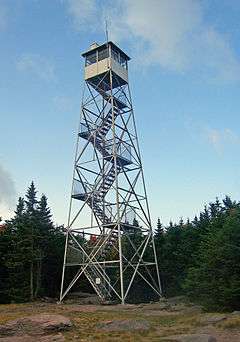
The Catskill Mountains fire towers were constructed to facilitate forest fire prevention and control. 23 fire towers were built in the Catskill Mountains between 1908 and 1950. The fire towers fell out of use by the 1970s as fire spotting from airplanes had become more effective and efficient, so the fire towers were decommissioned; the Hunter Mountain Fire Tower was the last to be taken out of service in 1990. All but five of the towers were dismantled. The five remaining towers have been renovated and opened to the public as observation posts in the Catskill Mountains because of the extraordinary views they provide. The remaining towers are:
- Balsam Lake Mountain Fire Observation Station – Town of Hardenburgh, New York – Elevation 3,723 ft (1,135 m)
- Hunter Mountain Fire Tower – Town of Hunter, New York – Elevation 4,042 ft (1,232 m)
- Overlook Mountain Tower – Town of Woodstock, New York – Elevation 3,140 ft (960 m)
- Red Hill Fire Tower – Town of Denning, New York – Elevation 2,990 ft (910 m)
- Tremper Mountain Fire Tower – Town of Shandaken, New York – Elevation 2,740 ft (840 m)
Notable landmarks
The Catskill Mountain House, built in 1824, was a famous hotel near Palenville, New York, in the Catskill Mountains overlooking the Hudson River Valley. In its prime to the turn of the century, it was visited by United States Presidents Ulysses S. Grant, Chester A. Arthur, and Theodore Roosevelt, as well as many other important personages.
Shortly after it was completed, the Mountain House became a favorite subject for Washington Irving and artists for the new Hudson River School, most notably artists Thomas Cole and William Henry Bartlett.
Transportation
From 1872, the Catskills were served by the Catskill Mountain Branch of the Ulster and Delaware Railroad which was absorbed into the New York Central railroad in 1932. Passenger rail service continued until 1954. Part of the line still exists but now serves only freight. The Delaware and Ulster Railroad is a heritage railroad, based in Arkville, New York, that still runs a scenic part of the track from Highmount to Hubbell Corners, New York for tourist use. The Catskill Mountain Railroad is also a heritage railroad in the Catskills, operating from Kingston, New York up to Highmount, New York.

The Catskills are accessible by automobile from the east along Interstate 87/New York State Thruway, which runs north-south through the Hudson Valley. To the south and southwest, the Catskills are accessible by a variety of highways, including New York State Route 55, U.S. Route 44, U.S. Route 209, and New York State Route 17 (also known as "Future I-86"). Access to the western Catskills is provided by New York State Route 30; and the vaguely defined far-western edge of the region is variously considered to be New York State Route 10 or Interstate 88, though this boundary remains a matter of local preference. New York State Routes 28 and 23A cut east-west through the heart of the Catskills, serving many of the most popular outdoor tourist destinations. New York State Route 23 runs east-west across the Catskills' far-northern section.
The closest major airports to the Catskill region are Albany International Airport to the north and Stewart International Airport in Newburgh to the south. Smaller airports in the region include the following:
- Columbia County Airport in Hudson
- Dutchess County Airport in Poughkeepsie
- Joseph Y. Resnick Airport in Ellenville
- Kingston-Ulster Airport
- Kobelt Airport in Wallkill
- Randall Airport in
- Sullivan County International Airport in Monticello
- Wurtsboro-Sullivan County Airport
In popular culture


Comics
- In Bill Willingham's comic book series Fables, the animals and other fairy tale characters live on "The Farm", an imaginary haven in the NY Catskills.
Films
The Hudson Valley Film Commission maintains an updated list of films set in the Hudson Valley / Catskills Region, including:[9] (Chronological)
- WaterFall in the Catskills (1897), the Edison Studio
- Rip Van Winkle (1921), silent film version of the classic story
- Having Wonderful Time (1938), Red Skelton's first movie, set in a Catskills hotel
- My Side of the Mountain (1969), film adaptation of Jean Craighead George's eponymous 1959 novel; a young boy tests his survival skills by living about two years in the Catskill Mountains
- Woodstock (1970), a documentary about the Woodstock Festival of 1969, filmed at the festival in Bethel, New York
- Magic (1978), a film starring Anthony Hopkins and set in the Catskills
- Tootsie (1982), features scenes in the Hurley Mountain Inn located in Ulster County, New York
- The Gig (1985), directed by Frank D. Gilroy; a character study of amateur musicians who get a gig
- Dirty Dancing (1987), a hit film set in a Catskills resort in the summer of 1963 (though filmed at Mountain Lake in Virginia and at Lake Lure in North Carolina)
- Sweet Lorraine (1987), the story of an aging Catskill resort in its last days, filmed at the former Heiden Hotel in South Fallsburg, New York
- Casper Meets Wendy (1995), Wendy and her aunts run into Casper and his uncles at a resort in the Catskills
- Heavy (1995), an independent film starring Liv Tyler, Debbie Harry, Pruitt Taylor Vince, Shelley Winters, and Joe Grifasi, filmed partially in the southern Catskills, in Barryville, New York and Highland Lake
- Manny & Lo (1996)
- Julian Po (1997), starring Christian Slater and filmed in Fleischmanns
- A Walk on the Moon (1999), set in Sullivan County, New York, but filmed in Quebec, Canada
- You Can Count on Me (2000), an award-winning independent film set in the village of Scottsville, in western New York near Rochester, but filmed in the Catskills, in and around Margaretville and Phoenicia
- Kaaterskill Falls (2001), an award-winning independent film about a young urban couple who befriend a local hitchhiker; it's a mountain country version of Roman Polanski's Polish-language film Knife in the Water (1962), actually filmed in the Catskills
- Wendigo (2001), filmed in the West Shokan and Phoenicia, New York area
- The Catskill Chainsaw Redemption (2004), a horror movie
- Parts of the movie Transamerica (2005), starring Felicity Huffman, were filmed in the town of Callicoon, New York, though in the movie it's referred to as Callicoon, Kentucky
- The burning train and ferry scenes in War of the Worlds (2005) were filmed in the town of Athens, New York at the foot of the Catskills
- Four Seasons Documentary (2006), follows the lives of Holocaust survivors in a Borscht Belt colony
- Stagedoor (2006), a documentary on life at a teen camp
- 99 Geiger Road (2007), a documentary about a bungalow colony of Holocaust survivors[10]
- The Cake Eaters (2007)
- Goyband (2008), a romantic comedy involving a musician performing at the opening of the first kosher casino in the Catskills
- Taking Woodstock (2009), the story of how Elliot Tiber helped bring the Woodstock Festival to Bethel, New York
- Mary Last Seen (2010), a short on the same theme as Martha Marcy May Marlene (available on the DVD)
- Stake Land (2010), a vampire/zombie apocalypse film, partially set and filmed in the Catskills
- Martha Marcy May Marlene (2011), a critically acclaimed film about a young woman who escapes from a cult in the Catskills
- New York State Office of Parks, Recreation and Historic Preservation (2013)[11]
- Studio360 (2013)[12]
Literature
- The Catskills and their inhabitants play an important role in Jean Craighead George's stories, such as My Side of the Mountain (1959)
- John Gardner's novel Nickel Mountain: A Pastoral Novel (1973) takes place in the Catskill Mountains
- Washington Irving wrote many famous stories, including "Rip Van Winkle" (1819), that take place in the Catskill Mountains
- The Catskills and their inhabitants play an important role the H. P. Lovecraft stories: "The Lurking Fear" (1922) and "Beyond the Wall of Sleep" (1919)
Music
Concerts

- The town of Bethel, New York, located in the Catskills was home to the famous Woodstock Music festival in 1969. The music festival took place from August 15 to August 18, 1969. 32 music acts performed in front of over 500,000 concert-goers. The event was captured in the documentary movie Woodstock (1970).
The site is now home to the world renowned Bethel Woods Center for the Arts.
Works
- Mercury Rev's song "Opus 40", on their album Deserter's Songs (1998), contains the line "Catskill mansions buried dreams/ I'm alive she cried but I don't know what it means". The band and their studios are based in the Catskills, and the area is often referred to in interview.
- Simple Minds filmed their video to "Alive and Kicking" (1985) here.
- The Catskills are mentioned in The Band's song "Time to Kill". The Band was also photographed there for their first album, Music from Big Pink, The Band in the Catskills.[13]
- The Catskills are mentioned in the Kid Rock track "Low Life". Contains the line " I've never hung out in The Catskills, but I been to jail in Nashville".
- A song on Odelay by Beck is called "High 5 (Rock the Catskills.)"
Stand up comedy
- The many hotels and vacation resorts located in the Catskills are notable in American cultural history for their role in the development of modern stand-up comedy. Comedians such as Rodney Dangerfield and Don Rickles and got their start performing in Catskill Hotel venues colloquially referred to as the Borscht Belt.[14]
Television
- A Home Box Office miniseries is planned that will dramatize a New York Magazine article on natural gas drillers coming to the region. Richard Russo, a winner of the Pulitzer Prize, is writing a script for the project.[15]
See also
- Catskill Creek
- Catskill Mountain 3500 Club
- Catskill Mountain fire towers
- Catskill Mountain House
- Catskill Mountain Railroad
- Helderberg Escarpment
- Hudson River School
- New York–New Jersey Trail Conference
- Shawangunk Ridge
- Woodstock Festival
References
- ↑ "REGIONAL TOPOGRAPHY". Catskills GIS Atlas. Catskill Center. Retrieved 2009-10-12.
- ↑ "Physiographic divisions of the conterminous U. S.". U.S. Geological Survey. Retrieved 2007-12-06.
- ↑ Kudish, Michael (2000). The Catskill Forest: A History. Fleischmanns, NY: Purple Mountain Press. p. 47. ISBN 1-930098-02-2.
- ↑ "The Elusive Mountain Lion – E-Files – Our History". Sierra Club. Retrieved 2007-09-17.
- ↑ "Whitewater Rivers in and near the Catskill Mountains, New York". Retrieved May 10, 2013.
- ↑ "Tour of the Catskills". Anthem Sports. Retrieved Dec 18, 2013.
- ↑ "Windham Mountain Bike World Cup Festival". Retrieved 2013-12-18.
- ↑ "The Catskills". The Walters Art Museum.
- ↑ "Woodstock Film Commission". Hudsonvalleyfilmcommission.org. Retrieved March 26, 2014.
- ↑ "99 Geiger Road". 99geigerroad.com. Retrieved 2014-03-26.
- ↑ "Catskill Region – NYS Parks, Recreation & Historic Preservation". Nysparks.com. Retrieved 2014-03-26.
- ↑ "Catskill Mountains – Catskill Mountains New York". Destination360.com. Retrieved 2014-03-26.
- ↑ "Photo". Theband.hiof.no. Retrieved 2014-03-26.
- ↑ "Comedians who became stars learned their craft in Catskill Mountain hotels". tribunedigital-sunsentinel. Retrieved 2016-01-14.
- ↑ Andreeva, Nellie (2009-09-07). "HBO taps scribe for Catskills drama". The Hollywood Reporter. Archived from the original on September 11, 2009. Retrieved 2009-09-12.
Further reading
- Heilprin, Angelo (1907). "The Catskill Mountains". Bulletin of the American Geographical Society. 39 (4): 193–201. doi:10.2307/198709. ISSN 0190-5929. JSTOR 198709.
- McIntosh, Robert P. (1962). "The forest cover of the Catskill Mountain region, New York, as indicated by land survey records". American Midland Naturalist. 68 (2): 409–23. doi:10.2307/2422746. ISSN 0003-0031. JSTOR 2422746.
- McIntosh, Robert P. (1972). "Forests of the Catskill Mountains, New York". Ecological Monographs. 42 (2): 143–61. doi:10.2307/1942261. JSTOR 1942261.
- McIntosh, R. P.; R. T. Hurley (1964). "The spruce-fir forests of the Catskill Mountains". Ecology. 45 (2): 314–26. doi:10.2307/1933844. ISSN 0012-9658. JSTOR 1933844.
- Rich, John Lyon (1906). "Local glaciation in the Catskill Mountains". The Journal of Geology. 14 (2): 113–21. doi:10.1086/621285. ISSN 0022-1376.
- Shepard, Paul (1957). "Paintings of the New England landscape: a scientist looks at their geomorphology". College Art Journal. 17 (1): 30–43. doi:10.2307/773655. ISSN 1543-6322. JSTOR 773655.
- Weathers, K. C.; G. M. Lovett; G. E. Likens; R. Lathrop (2000). "The effect of landscape features on deposition to Hunter Mountain, Catskill Mountains, New York". Ecological Applications. 10 (2): 528–40. doi:10.1890/1051-0761(2000)010[0528:TEOLFO]2.0.CO;2. ISSN 1051-0761.
External links
| Wikimedia Commons has media related to Catskill Mountains. |
| Wikivoyage has a travel guide for Catskills. |
| Wikisource has the text of the 1921 Collier's Encyclopedia article Catskill Mountains. |
 "Catskill Mountains". Encyclopædia Britannica. 5 (11th ed.). 1911.
- Hiking Guide to Catskill High Peaks Catskill 3500 Club
- History of Catskill Mountains Sleepaway Camps
- Website for the Catskill Mountain Club hiking
- The Catskill Archive – History of the Catskill Mountains
- The Catskill Mountain Foundation
- The Catskill Center
- The Catskill Watershed Corporation
- Catskill Region Photo Gallery
- Catskill Mountainkeeper Protecting the Six Counties of the Catskills
- Catskill Mountain Businesses listed on Hudson Valley Directory
- Sullivan County Visitors Association
| Counties |  | |
|---|---|---|
| Major cities and towns | ||
| Cities over 100,000 | ||
| Cities and towns over 25,000 |
| |
| Cities and towns over 10,000 |
| |
| Regions | ||