Cathedral Peak (Montana)
This article is about Cathedral Peak (Montana). For other uses, see Cathedral Peak.
| Cathedral Peak | |
|---|---|
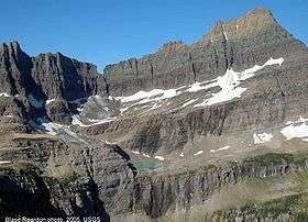 Cathedral Peak summit in upper right above the remnant Shepard Glacier | |
| Highest point | |
| Elevation | 9,041 ft (2,756 m) .[1] |
| Prominence | 1,481 ft (451 m) [1] |
| Coordinates | 48°52′8″N 113°51′58″W / 48.86889°N 113.86611°WCoordinates: 48°52′8″N 113°51′58″W / 48.86889°N 113.86611°W[2] |
| Geography | |
| Location | Glacier County, Montana, U.S. |
| Parent range | Lewis Range |
| Topo map | USGS Ahern Pass |
Cathedral Peak (9,041 feet (2,756 m)) is located in the Lewis Range, Glacier National Park in the U.S. state of Montana.[1] Shepard Glacier is situated immediately southeast of the peak.[3]
See also
References
- 1 2 3 "Cathedral Peak, Montana". Peakbagger.com. Retrieved 2010-02-28.
- ↑ "Cathedral Peak". Geographic Names Information System. United States Geological Survey. Retrieved 2010-09-26.
- ↑ "Cathedral Peak, Montana". My Topo (USGS Quads). Retrieved 2010-02-28.
This article is issued from Wikipedia - version of the 3/26/2016. The text is available under the Creative Commons Attribution/Share Alike but additional terms may apply for the media files.