Castel del Piano
| Castel del Piano | ||
|---|---|---|
| Comune | ||
| Comune di Castel del Piano | ||
 | ||
| ||
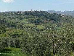
 Castel del Piano Location of Castel del Piano in Italy | ||
| Coordinates: IT 42°53′27″N 11°32′22″E / 42.89083°N 11.53944°ECoordinates: IT 42°53′27″N 11°32′22″E / 42.89083°N 11.53944°E | ||
| Country | Italy | |
| Region | Tuscany | |
| Province / Metropolitan city | Province of Grosseto (GR) | |
| Frazioni | Montegiovi, Montenero d'Orcia | |
| Government | ||
| • Mayor | Claudio Franci | |
| Area | ||
| • Total | 67.79 km2 (26.17 sq mi) | |
| Elevation | 637 m (2,090 ft) | |
| Population (2001) | ||
| • Total | 4,331 | |
| • Density | 64/km2 (170/sq mi) | |
| Demonym(s) | Casteldelpianesi or Cioli | |
| Time zone | CET (UTC+1) | |
| • Summer (DST) | CEST (UTC+2) | |
| Postal code | 58033 | |
| Dialing code | 0564 | |
| Patron saint | Maria Santissima delle Grazie | |
| Saint day | September 8 | |
| Website | Official website | |

Castel del Piano is a town and comune (municipality) of Grosseto province in the Italian region of Tuscany.

Chiesa della Propositura, Castel del Piano.
History
The area of Castel del Piano is known to have been inhabited in prehistoric times, but the town itself is mentioned for the first time in a document from 890 AD. From 1175 to 1321 it was a possession of the Aldobrandeschi family. After the fall of the Republic of Siena, it became part of the Grand Duchy of Tuscany.
Culture
The city is divided into four contrade (quarters) which take part in a palio held every 8 September. The palio was raced for the first time in 1402.
The contrade are:
- Borgo
- Monumento
- Poggio
- Storte
Main sights
- Chiesa della propositura
- Chiesa di Santa Maria delle Grazie
.jpg)
The Virgin Mary and Jesus in the Chiesa di Santa Maria delle Grazie
See also
External links
- Southern Tuscany - Map It Out! Useful travel information and updated events in Castel del Piano and Southern Tuscany
| Wikimedia Commons has media related to Castel del Piano. |
This article is issued from Wikipedia - version of the 5/18/2015. The text is available under the Creative Commons Attribution/Share Alike but additional terms may apply for the media files.