Carter Bar
Coordinates: 55°21′14″N 2°28′41″W / 55.354°N 2.478°W
| Carter Bar | |
|---|---|
 Carter Bar | |
| OS grid reference | NT697068 |
| |
Carter Bar is a point on the England–Scotland border, in Roxburghshire and Northumberland.
Carter Bar is where the A68 road crosses the border and forms a pass located at the top of Redesdale in the Cheviot Hills at an elevation of 418 metres (1,371 ft).
The nearest Scottish towns are Jedburgh (12 miles (19 km) north), Hawick, and Kelso, and on the English side, Byrness, Redesdale and Otterburn. From Carter Bar, Newcastle upon Tyne is 45 miles (72 km) away and the Scottish capital, Edinburgh, 58 miles (93 km). The A696–A68 route is a popular scenic tourist route between Newcastle and Edinburgh.
History
In 1575 Carter Bar was the scene of the Raid of the Redeswire, one of the last large-scale battles between the English and the Scots.
Carter Bar was the location of Truce days, that were held between the Lord Wardens of the Marches of both countries to dispense cross border justice in the Late Middle Ages and Early modern period. Truce days were also held at Carlisle and Berwick upon Tweed.
Tourism
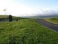
Carter Bar forms a popular point for tourists to stop and take photographs on the Anglo-Scottish border. There are two marker stones on either side of the A68 for this purpose, the original stone created by local Borders stonemason, Edy Laub. Upper Redesdale, the Scottish Borders (including Tweeddale) and to the east, the Cheviot hills are all visible from Carter Bar. However, its altitude means snow is possible even in late spring and early autumn, and the Carter Bar pass can be subject to frequent snow-related closures during the winter.
-
Carter Bar, 2009
-
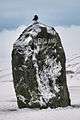
Boundary stone
-

Carter Bar in 1960
-

Carter Bar trig stone
-
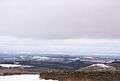
The Scottish Borders from Carter Bar
-

Road viewpoint in 2005
-
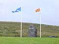
Flags of Scotland and Northumberland
See also
External links
- RCAHMS: Martinlee Sike
- Scottish Borders Council: Carter Bar / Homecoming 2009
- Scottish Borders Council, windfarm proposal