Carroll Gardens, Brooklyn
Coordinates: 40°40′48″N 73°59′40″W / 40.68000°N 73.99444°W


Carroll Gardens is a neighborhood in the New York City borough of Brooklyn. Taking up around 40 city blocks, it is bounded by Degraw and Warren Streets (north), Hoyt and Smith Streets (east), Ninth Street or the Gowanus Expressway (south) and the Brooklyn Queens (BQE) and Gowanus Expressways (west).[1][2][3] The neighborhoods that surround it are Cobble Hill to the northwest, Boerum Hill to the northeast, Gowanus to the east, Red Hook to the south and southwest, and the Columbia Street Waterfront District to the west.[4]
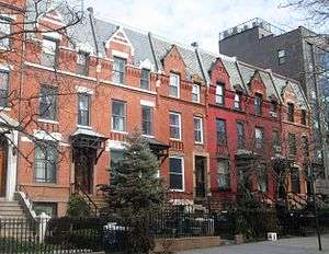
Originally considered to be part of South Brooklyn or, more specifically, Red Hook, the neighborhood started to have its own identity in the 1960s.[1][5] The new name came from Charles Carroll, an Irish immigrant who was the only Roman Catholic signer of the Declaration of Independence, and whose name was already attached to Carroll Street and Carroll Park.[6] The name also reflects the large front gardens of brownstones in the Carroll Gardens Historic District and elsewhere in the neighborhood.
Carroll Gardens is part of Brooklyn Community Board 6,[7] and receives police services from the New York City Police Department's 76th Precinct at 191 Union Street. The Fire Department of New York City's firehouses are located at 299 Degraw Street (Engine Company 204) and 187 Union Street (Engine Company 216 and Ladder Company 108).[2]
History
19th century
Carroll Gardens was settled in the 19th century by immigrants from Ireland,[1] followed in the middle of the century by Norwegian immigrants,[8] who founded two churches, the Norwegian Seaman's Church (formerly the Westminster Presbyterian Church), now apartments, and the Norwegian Methodist Episcopal Church (formerly the Carroll Park Methodist Episcopal Church, no longer extant.[9]
The development of the South Brooklyn area, including Carroll Gardens, was aided by the foundation in 1846 by philanthropists Henry Pierrepont and Jacob E. Leroy of the Hamilton Avenue Ferry. Its purpose was to improve transportation to the newly created Green-Wood Cemetery, but horse car service, and later trolley lines, connecting to the ferry ran through Carroll Gardens, enabling businessmen who lived there to more easily commute to work in Manhattan.[5]
In the late 1840s, Carroll Park, Brooklyn's third-oldest, a block-long area of playgrounds, walkways and sitting areas between Court, Smith, Carroll, and President Streets was built. Originally a private garden, it was purchased by the city in 1853, and was named after Charles Carroll in honor of his Maryland regiment, which had helped to defend the area during the Battle of Long Island in the American Revolutionary War.[5][6][10]
In 1846, surveyor Richard Butt planned gardens in front of the brownstone houses in the oldest section of the neighborhood when he developed it.[2] The homes are set further back from the street than is common in Brooklyn, and the large gardens became an iconic depiction of the neighborhood. The same year, a law was passed requiring that all buildings between Henry Street and Smith Street have 33 feet 5.25 inches (10.1918 m) between the building and the street for "courtyards".[11] The large gardens can be seen from First to Fourth Place between Henry and Smith Streets, as well as on President, Carroll and Second Streets between Smith and Hoyt Streets.[1]
Further development of the Carroll Gardens was aided by the draining in the late 1860s of the swampland which surrounded Gowanus Creek through the deepening and dredging of the Creek to create the Gowanus Canal. This provoked land speculation and a building boom throughout the area. It was during this period, from the late 1860s to the early 1880s, that the area which is now the Carroll Gardens Historic District began to be developed.[5]
20th century
Italian immigrants began coming to the neighborhood in the late 19th century – dock workers and workers in the Brooklyn Navy Yard[2] – continuing through the 1950s, which led to much of the Irish population of the area leaving beginning in the 1920s.[1] The rise of the Italian population provoked questions about the role of the Mafia in the neighborhood. One theory has it that Carroll Gardens, which lies between a territory traditionally controlled by the Gambino crime family and one controlled by the Colombo family, is considered to be neutral territory, and has been, for the most part, left alone.[2]

Carroll Gardens had long been considered to be part of either the larger area referred to as South Brooklyn, or the neighborhood known as Red Hook. That neighborhood had an informal division in the 1930s and 40s along Hamilton Avenue, with kids from south of the avenue, mostly of Italian descent, calling themselves "Hookers" or "Hookies" after Red Hook, and kids north of the street, mostly Irish, in what would now be Carroll Gardensm called "Creekers" or "Creekies" after the now-drained Gowanus Creek.[2][12] Violence between the two groups was common.[12] The division between the neighborhoods became even stronger beginning in the late 1940s by the building of the Brooklyn-Queens Expressway and the Gowanus Expressway, which started the process of the Carroll Gardens area taking on a separate and distinct character of its own.
In the 1960s, young middle-class professionals began to be attracted to the Carroll Garden area due to its convenience to Manhattan, where many of them worked, and its growing reputation as a safe and quiet place to live. This began the gentrification of the neighborhood, and a response from older residents, who did not appreciate these "hippie" newcomers who had no ties to the community. Regardless, the neighborhood gradually received its own name at that time,[2] and the Carroll Gardens Association was formed in 1964. One result was that the decades-long control of the area by a political machine was ended.[1][2]
Today, Carroll Gardens is more middle class, while Red Hook, which had retained its working-class, waterfront ambiance, has only recently begun to feel the effects of gentrification.[13] The ethnic divide between the two neighborhoods now has a racial character as well. As late as the 1990s, several highly publicized incidents of violence underscored the tension between African-Americans from Red Hook and the mostly Italian residents of Carroll Gardens.[12]
21st century
Carroll Gardens has seen some French immigration since the late 1990s, and Bastille Day celebrations are held on July 14 of each year.[14][15] International School of Brooklyn, a Nursery-8th grade independent school, offers a French and Spanish language immersion. One of the public schools in Carroll Gardens, the Carroll School, has one of the area's French dual-language programs.[16][17]
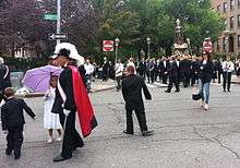
Though still visible in local business and culture, the Italian segment of the community has decreased significantly from 52 percent of the population in 1980 to 22 percent in 2012.[18] Still, despite the decline in the Italian segment of the population and the effects of gentrification, the neighborhood remains a strongly Italian one. Italians in the neighborhood often play Bocce games, speak several dialects of Italian, and operate many Italian restaurants and shops, as well as join fraternal and benevolent associations attached to specific towns in Italy.[1] The Roman Catholicism of the Italian population is still evident in the many shrines, especially to the Virgin Mary, which can be seen in front gardens in the neighborhood, and the tradition of a procession celebrating Good Friday continues.[2] Adult children who had moved away from Carroll Gardens have started returning to the neighborhood to raise their children.[2]
Carroll Gardens Historic District
The development of what is now the Carroll Gardens Historic District began in the 1870s, due in part to its proximity to Carroll Park. The district was created by the New York City Landmarks Preservation Commission in 1973. It includes houses located in a rough rectangle bounded by Carroll, President, Smith, and Hoyt Streets, as well as the western ends of the two blocks between President Street and First Street. The district includes some of the finest examples of brownstones with large front gardens.[5]
Points of interest
- The John Rankin House, 440 Clinton Street, built c.1840 in the Greek Revival style. When Rankin, a wealthy merchant, built this house, which was one of the largest of the 1840s in Brooklyn, the area was still primarily farmland, and the house had a view of Upper New York Bay. The house was designated a New York City landmark in 1970 and was added to the National Register of Historic Places in 1978.[2][9][19][20]
- The South Congregational Church Complex included the Early Romanesque Revival Church and Chapel at 358-366 Court Street, built in 1851 (chapel) and 1857 (church); the neo-Gothic Rectory at 255 President Street, built in 1893 and designed by Woodruff Leeming; and the Ladies Parlor at 257 President Street, built in 1889 and designed by F. Carles Merry in the Romanesque Revival style. At one time the chapel became the Calvary Baptist Church of Red Hook. All of the buildings have been converted to condominium apartments. The complex in a New York City landmark, designated in 1982.[2][9][19]
- St. Paul's Episcopal Church at 199 Carroll Street. The congregation was founded in 1849, during the heyday of Brooklyn's industrialization, and the church was built in 1867-84 and was designed by the firm Richard Upjohn & Son in the Victorian Gothic style.[2][9]
- The Sacred Hearts of Jesus and Mary and St. Stephen's Church at Summit and Hicks Streets, was built c.1860 as St. Stephen's Church; the parish's name changed when it merged with another which lost its church in 1941 due to the building of the Brooklyn Queens Expressway. This church was designed by Patrick Charles Keely in the Gothic Revival style.[2][9][21]
- The Westminster Presbyterian Church at 450 Clinton Avenue at First Place was built c.1865 in the Romanesque Revival style. It became Den Norske Sjomannskirke (the Norwegian Seaman's Church), founded by Norwegian immigrants; it was once visited by the King of Norway during an official visit to the United States. The church has now been converted to condominium apartments.[2][8][9]
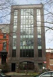
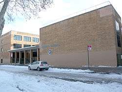
- St. Mary's Star of the Sea Church, located at 471 Court Street between Luquer and Nelson Streets was built in 1853 and was designed by Patrick Charles Keely. Originally constructed to serve as a cathedral, the church was built with Italian and European stones and marble. The church was where Al Capone married Mae Josephine Coughlin. A rectory and a girls' school – now the International School of Brooklyn – are also part of the church complex.[2][2][9][22][23]
- Dennett Place is a short mews of residences running between Luquer and Nelson Streets in the block between Court and Smith Streets.[9]
 Sacred Hearts of Jesus and Mary and St. Stephen's Church
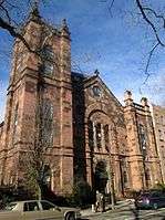 Westminster Presbyterian, later Norwegian Seamen's Church, now apartments
 South Congregational Church, now apartments
 St Mary Star of the Sea Church

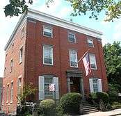 John Rankin House, now a funeral home
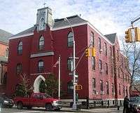 The International School of Brooklyn, formerly a parish school for girls of St. Mary Star of the Sea
Education
The New York City Department of Education operates a number of public schools in the neighborhood: Patrick F. Daly (P.S. 15), John M. Harrigan (P.S. 29), Carroll School (P.S. 58), Samuel Mills Sprole (P.S. 32), the Brooklyn New School (P.S. 146), Brooklyn School of Collaborative Studies (M.S. 448), and the School for Innovation (M.S. 442).
Also in the area are the New Dawn Charter High School, International School of Brooklyn, Hannah Senesh Community Day School, the Mary McDowell Friends Middle School, and St. Mary's School.
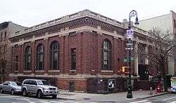
The Brooklyn Public Library operates the Carroll Gardens Branch at 396 Clinton Street and Union Street in Carroll Gardens. The library, originally the Carroll Park Branch, opened in 1901 in a rented facility. The library moved to its current Carnegie library facility, designed by William B. Tubby, in 1905. After extensive renovations, the library received its current name in response to a request from the community.[24]
Transportation
- The New York City Subway's Carroll Street and Smith–Ninth Streets stations service the F G trains.[25]
- Bus service through the neighborhood is available from the B61 on 9th Street and the B57 on Court and Smith Streets.[25]
Notable residents
- Stanley Crouch, poet, music and cultural critic, syndicated columnist, novelist and biographer
- Michelle Goldberg, journalist and author
- Stacy London (b. 1969), fashion stylist and media personality[26]
- Jim Neu (1943–2010), playwright.[27]
- Joe Sarno (1921–2010), sexploitation film pioneer[28]
In popular culture
- In the 1987 film Moonstruck, the characters played by Cher and Nicolas Cage met at the Cammareri Brothers Bakery on Henry Street in Carroll Gardens.[2]
See also
 New York City portal
References
Notes
- 1 2 3 4 5 6 7 Ellin, Nan. "Carroll Gardens" in Jackson, Kenneth T., ed. (2010), The Encyclopedia of New York City (2nd ed.), New Haven: Yale University Press, ISBN 978-0-300-11465-2, p.107
- 1 2 3 4 5 6 7 8 9 10 11 12 13 14 15 16 17 18 "Carroll Gardens" in Jackson and Manbeck (2004), pp.54-57
- ↑ "Carroll Gardens" on Google Maps. Accessed: February 20, 2015
- ↑ Map at Jackson and Manbeck (2004), p.xxxi
- 1 2 3 4 5 "Carroll Gardens Historic District Designation Report" New York City Landmarks Preservation Commission (September 25, 1973)
- 1 2 "Carroll Park" on the New York City Department of Parks and Recreation website. Accessed October 1, 2007.
- ↑ Neighborhoods Archived July 15, 2006, at the Wayback Machine., Brooklyn Community Board 6. Accessed October 1, 2007.
- 1 2 "Carroll Gardens, a Cozy Brooklyn Locale" Archived January 7, 2015, at the Wayback Machine. Ctty (July 24, 2014)
- 1 2 3 4 5 6 7 8 "Carroll Gardens" in White, Norval; Willensky, Elliot; Leadon, Fran (2010), AIA Guide to New York City (5th ed.), New York: Oxford University Press, ISBN 9780195383867, pp.625-628
- ↑ Donovan, Aaron. "If You're Thinking of Living In/Carroll Gardens; Area of Gardens and 19th-Century Charm", The New York Times(May 12, 2002). Accessed October 1, 2007
- ↑ Carroll Gardens Neighborhood Association website Accessed: June 6, 2014
- 1 2 3 Martin, Douglas (September 28, 1997). "In Brooklyn, 2 Worlds on an Edge; At the Scene of a Bias Beating, a Line Divides Red Hook and Carroll Gardens". The New York Times.
- ↑ "Red Hook" in Jackson and Manbeck (2004), pp.187-190
- ↑ Szabla, Christopher. "The Italians, the French, and the Catholic Shrines of Brooklyn" Maisonneuve(December 6, 2011)
- ↑ Hays, Elizabeth. "Brooklyn's old Italian stronghold is becoming more and more French" New York Daily News (March 9, 2009]
- ↑ Mokha, Kavita (June 6, 2011). "Learning to Be French in Brooklyn". The Wall Street Journal.
- ↑ Semple, Kirk (January 30, 2014). "A Big Advocate of French in New York's Schools: France". The New York Times.
- ↑ Gill, John Freeman (March 11, 2014). "New Roots in Carroll Gardens". The New York Times. Retrieved June 6, 2014.
- 1 2 "Carroll Gardens, Gowanus" in New York City Landmarks Preservation Commission; Dolkart, Andrew S. (text); Postal, Matthew A. (text) (2009), Postal, Matthew A., ed., Guide to New York City Landmarks (4th ed.), New York: John Wiley & Sons, ISBN 978-0-470-28963-1, pp.247-249
- ↑ "John Rankin House Designation Report" New York City Landmarks Preservation Commission (July 14, 1970)
- ↑ "A Brief History" on the Sacred Hearts of Jesus and Mary and St. Stephen's Church website
- ↑ "Laying the Corner Stone of a Catholic Church" Brooklyn Daily Eagle (July 18, 1853)
- ↑ "History" on the International School of Brooklyn website
- ↑ "Carroll Gardens Branch" Brooklyn Public Library website. Retrieved on March 28, 2010.
- 1 2 "Brooklyn Bus Map" (PDF). Metropolitan Transportation Authority. Retrieved 20 February 2015.
- ↑ Velocci, Cristina; LeWinter, Rachel (September 7, 2010). "Most stylish New Yorkers: Stacy London". Time Out. Archived from the original on June 20, 2012. Retrieved June 20, 2012.
- ↑ Weber, Bruce. "Jim Neu, Creator of Wry Plays, Is Dead at 66", The New York Times, July 21, 2010. Accessed July 21, 2010.
- ↑ Grimes, William. "Joseph Sarno, Sexploitation Film Director, Dies at 89" The New York Times (May 3, 2010)
Bibliography
- Jackson, Kenneth T.; Manbeck, John B., eds. (2004), The Neighborhoods of Brooklyn (2nd ed.), New Haven, Connecticut: Citizens for NYC and Yale University Press, ISBN 0-300-10310-7
External links
| Wikimedia Commons has media related to Carroll Gardens, Brooklyn. |