Carroll, Ohio
| Carroll, Ohio | |
|---|---|
| Village | |
|
Market Street north of Lock Street | |
 Location of Carroll, Ohio | |
 Location of Carroll in Fairfield County | |
| Coordinates: 39°47′57″N 82°42′16″W / 39.79917°N 82.70444°WCoordinates: 39°47′57″N 82°42′16″W / 39.79917°N 82.70444°W | |
| Country | United States |
| State | Ohio |
| County | Fairfield |
| Area[1] | |
| • Total | 0.32 sq mi (0.83 km2) |
| • Land | 0.32 sq mi (0.83 km2) |
| • Water | 0 sq mi (0 km2) |
| Elevation[2] | 837 ft (255 m) |
| Population (2010)[3] | |
| • Total | 524 |
| • Estimate (2012[4]) | 524 |
| • Density | 1,637.5/sq mi (632.2/km2) |
| Time zone | Eastern (EST) (UTC-5) |
| • Summer (DST) | EDT (UTC-4) |
| ZIP code | 43112 |
| Area code(s) | 740 |
| FIPS code | 39-12252[5] |
| GNIS feature ID | 1056768[2] |

Carroll is a village in Fairfield County, Ohio, United States. The population was 524 at the 2010 census.
History
Carroll had its start when the canal was extended to that point.[6]
Geography
Carroll is located at 39°47′57″N 82°42′16″W / 39.79917°N 82.70444°W (39.799228, -82.704311).[7]
According to the United States Census Bureau, the village has a total area of 0.32 square miles (0.83 km2), all land.[1]
Demographics
| Historical population | |||
|---|---|---|---|
| Census | Pop. | %± | |
| 1870 | 187 | — | |
| 1880 | 288 | 54.0% | |
| 1890 | 293 | 1.7% | |
| 1900 | 223 | −23.9% | |
| 1910 | 284 | 27.4% | |
| 1920 | 348 | 22.5% | |
| 1930 | 351 | 0.9% | |
| 1940 | 337 | −4.0% | |
| 1950 | 416 | 23.4% | |
| 1960 | 444 | 6.7% | |
| 1970 | 614 | 38.3% | |
| 1980 | 641 | 4.4% | |
| 1990 | 558 | −12.9% | |
| 2000 | 488 | −12.5% | |
| 2010 | 524 | 7.4% | |
| Est. 2015 | 520 | [8] | −0.8% |
2010 census
As of the census[3] of 2010, there were 524 people, 208 households, and 147 families residing in the village. The population density was 1,637.5 inhabitants per square mile (632.2/km2). There were 218 housing units at an average density of 681.3 per square mile (263.1/km2). The racial makeup of the village was 96.2% White, 0.6% African American, 0.4% Native American, 0.2% Asian, and 2.7% from two or more races.
There were 208 households of which 36.5% had children under the age of 18 living with them, 45.2% were married couples living together, 18.3% had a female householder with no husband present, 7.2% had a male householder with no wife present, and 29.3% were non-families. 24.0% of all households were made up of individuals and 9.2% had someone living alone who was 65 years of age or older. The average household size was 2.52 and the average family size was 2.94.
The median age in the village was 38 years. 25.4% of residents were under the age of 18; 10.1% were between the ages of 18 and 24; 26.9% were from 25 to 44; 23.9% were from 45 to 64; and 13.7% were 65 years of age or older. The gender makeup of the village was 51.0% male and 49.0% female.
2000 census
As of the census[5] of 2000, there were 488 people, 189 households, and 130 families residing in the village. The population density was 1,777.3 people per square mile (697.8/km²). There were 205 housing units at an average density of 746.6 per square mile (293.2/km²). The racial makeup of the village was 99.59% White, 0.20% Native American and 0.20% Asian. Hispanic or Latino of any race were 0.20% of the population.
There were 189 households out of which 34.4% had children under the age of 18 living with them, 52.9% were married couples living together, 12.2% had a female householder with no husband present, and 30.7% were non-families. 27.0% of all households were made up of individuals and 9.5% had someone living alone who was 65 years of age or older. The average household size was 2.58 and the average family size was 3.12.
In the village the population was spread out with 26.8% under the age of 18, 9.8% from 18 to 24, 31.4% from 25 to 44, 20.5% from 45 to 64, and 11.5% who were 65 years of age or older. The median age was 34 years. For every 100 females there were 89.9 males. For every 100 females age 18 and over, there were 90.9 males.
The median income for a household in the village was $40,221, and the median income for a family was $41,250. Males had a median income of $31,354 versus $22,344 for females. The per capita income for the village was $16,311. About 4.0% of families and 5.7% of the population were below the poverty line, including 3.5% of those under age 18 and 18.8% of those age 65 or over.
History
Carroll was the juncture point of the Ohio and Erie Canal and the Hocking Canal. A number of warehouses were constructed along the canals to store goods prior to transport.
Local farmer David Brandt's no-till farming using cover crops was featured in the national press in 2013.[10]
Notable people
- James J. Jeffries, a.k.a. "The Boilermaker" - World Heavyweight Boxing Champion from 1899-1905, was born in Carroll.
- Tom Crabtree, professional football player for the Green Bay Packers
References
- 1 2 "US Gazetteer files 2010". United States Census Bureau. Archived from the original on 2012-07-14. Retrieved 2013-01-06.
- 1 2 "US Board on Geographic Names". United States Geological Survey. 2007-10-25. Retrieved 2008-01-31.
- 1 2 "American FactFinder". United States Census Bureau. Retrieved 2013-01-06.
- ↑ "Population Estimates". United States Census Bureau. Archived from the original on 2013-06-17. Retrieved 2013-06-17.
- 1 2 "American FactFinder". United States Census Bureau. Archived from the original on 2013-09-11. Retrieved 2008-01-31.
- ↑ Miller, Charles Christian (1912). History of Fairfield County, Ohio, and representative citizens. Chicago, Richmond-Arnold Pub. Co. p. 136.
- ↑ "US Gazetteer files: 2010, 2000, and 1990". United States Census Bureau. 2011-02-12. Retrieved 2011-04-23.
- ↑ "Annual Estimates of the Resident Population for Incorporated Places: April 1, 2010 to July 1, 2015". Retrieved July 2, 2016.
- ↑ "Census of Population and Housing". Census.gov. Archived from the original on May 11, 2015. Retrieved June 4, 2015.
- ↑ Philpott, Tom (2013-09-09). "One Weird Trick to Fix Farms Forever". Mother Jones. Retrieved 2014-03-14.
External links
Municipalities and communities of Fairfield County, Ohio, United States | ||
|---|---|---|
| Cities | 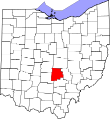 | |
| Villages | ||
| Townships | ||
| CDPs | ||
| Unincorporated communities | ||
| Footnotes | ‡This populated place also has portions in an adjacent county or counties | |