Carrick Roads
Coordinates: 50°09′12″N 5°02′08″W / 50.15333°N 5.03556°W
Carrick Roads (Cornish: Dowr Carrek, meaning "rock anchorage")[1] is the estuary of the River Fal on the south coast of Cornwall in England, United Kingdom. It joins the English Channel at its southern end near Falmouth. It is a large flooded valley created after the Ice age by the melt waters that caused the sea level to rise dramatically (see Ria), creating a large natural harbour which is navigable from Falmouth to Truro.[2]
The Carrick Roads can be seen well from the Trelissick Peninsula. From this viewpoint the waters stretch away towards Falmouth. On the left is Camerance Point, a tree-clad promontery. The Feock Peninsula is on the right and beyond that is the creek leading to Mylor village, with the Fal Estuary in the distance behind. Nearby lie the gardens of Trelissick House with their oaks, pines, beeches, rhododendrons, azaleas and camellias.[3]
The Roads are crossed by the historic and scenic King Harry Ferry, a vehicular chain ferry that links the parishes of Feock and Philleigh. The fiord-like inlet which houses the ferry, and others nearby are deep and steep-sided, are used as berths for mothballed tankers and container ships, allowing glimpses of the superstructure of large vessels to be seen through the trees.[3]
Carrick Roads and the Fal Estuary are favoured by ornithologists for birdwatching, especially the waders and waterbirds that visit in autumn and winter. The little egret and kingfisher can be seen all year while various passage waders pass through in spring, late summer and autumn. These include the whimbrel, the spotted redshank, the greenshank, the common sandpiper, the curlew sandpiper and the little stint. In the winter, the great northern diver and the black-throated diver can be seen, as well as the black-necked grebe, the red-necked grebe and the Slavonian grebe, the goldeneye and red-breasted merganser, and sometimes the long-tailed duck and the scoter.[4]
The Carrick Roads have large tidal flows; the water starts to recede six hours and five minutes before high water at Dover. Tidal speeds can reach three knots in the upper parts of the basin and one and a half to two in the lower stretches. The journey from Truro to Falmouth is a Grade A route for kayakers.[5]
The Falmouth Harbour Commissioners are the statutory port authority with responsibility for the Inner Harbour at Falmouth (excluding Falmouth Docks), the Penryn River up as far as Boyers Cellars, the southern part of the Carrick Roads and a large part of Falmouth Bay. It issues directions for speed limits in Carrick Roads.[6]
Gallery
-

King Harry Ferry between Trelissick and Roseland
-
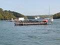
Carrick Roads near Trelissick
-

An aerial view showing Carrick Roads, Truro and Falmouth
-

The Feock terminal of the King Harry Ferry in 2005
-
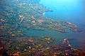
Carrick Roads in Cornwall bordered by Penryn, Falmouth & St. Mawes. Taken from flight AF0349

References
- ↑ Weatherhill, Craig (2009). A Concise Dictionary of Cornish Place-Names. Westport, Co. Mayo: Evertype. ISBN 9781904808220; p. 9
- ↑ Eric C. F. Bird (2011). Coastal Geomorphology: An Introduction. John Wiley & Sons. p. 361. ISBN 978-1-119-96435-3.
- 1 2 Simon Jenkins (2013). South West England's Best Views. Profile Books. pp. 4–6. ISBN 978-1-78283-060-3.
- ↑ David Tipling (2006). Where to Watch Birds in Britain and Ireland. New Holland Publishers. p. 14. ISBN 978-1-84537-459-4.
- ↑ Mark Rainsley (2011). South West Sea Kayaking: Isle of Wight to the Severn Estuary. Echo eBooks Limited. p. 203. ISBN 978-1-906095-28-4.
- ↑ "Falmouth Harbour Commissioners Home". Falmouthport.co.uk. Retrieved 2012-02-04.