Carbis Bay railway station
| Carbis Bay | |
|---|---|
 | |
| Location | |
| Place | Carbis Bay |
| Local authority | Cornwall |
| Coordinates | 50°11′50″N 5°27′51″W / 50.19730°N 5.46424°WCoordinates: 50°11′50″N 5°27′51″W / 50.19730°N 5.46424°W |
| Grid reference | SW528387 |
| Operations | |
| Station code | CBB |
| Managed by | Great Western Railway |
| Number of platforms | 1 |
| DfT category | F2 |
|
Live arrivals/departures, station information and onward connections from National Rail Enquiries | |
| Annual rail passenger usage* | |
| 2010/11 |
|
| 2011/12 |
|
| 2012/13 |
|
| 2013/14 |
|
| 2014/15 |
|
| History | |
| Original company | Great Western Railway |
| Opened | 1877 |
| National Rail – UK railway stations | |
| * Annual estimated passenger usage based on sales of tickets in stated financial year(s) which end or originate at Carbis Bay from Office of Rail and Road statistics. Methodology may vary year on year. | |
|
| |
Carbis Bay railway station is situated on the St Ives Bay Line in Cornwall, United Kingdom and serves village and beach of Carbis Bay, a community that only adopted this name after the arrival of the railway in 1877.
The station comprises a single platform. Carbis Viaduct is situated on the St Ives (west) side of the station.
History
The station was opened by the Great Western Railway on 1 June 1877 on their new branch line from St Erth to St Ives. The railway needed a viaduct to cross the small valley that carried Carbis Water down to the Baripper Cove. It was decided to build a station on the east side of the valley and call it Carbis Bay. The location proved popular with visitors and the small farms around Wheal Providence mine expanded to become the village of Carbis Bay, named after the station.[1]
The station buildings were not on the platform, rather they were at the top of the shallow cutting in which the station is built.[2] Goods traffic was withdrawn in May 1956.[3]
Description
The station is 3 miles (4.8 km) from St Erth. There is a single platform situated in a shallow cutting north of the road that leads down to the beach. It is on the left of trains arriving from St Erth. There is a small car park at the station entrance but a larger one is available a short distance away by the beach.
Services
All trains are operated by Great Western Railway. Most run between St Ives and St Erth, but some are extended through to Penzance.[4]
| Preceding station | |
Following station | ||
|---|---|---|---|---|
| Lelant | Great Western Railway St Ives Bay Line |
St Ives | ||
Carbis Viaduct
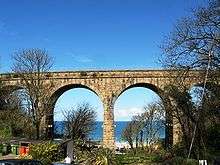
Carbis Viaduct is a short distance beyond the station towards St Ives. It is built of granite from a nearby quarry at Towednack and has three piers supporting four 40 feet (12 m) arches, giving a total length of 78 yards (71 m); it is 78 feet (24 m) high.[2][5]
References
| Wikimedia Commons has media related to Carbis Bay railway station. |
- ↑ Bray, Lena; Bray, Donald (1992) [1981]. St Ives Heritage (Second ed.). Devoran: Landfall Publications. ISBN 1-873443-06-4.
- 1 2 Bennett, Alan (1990) [1988]. The Great Western Railway in West Cornwall (2 ed.). Cheltenham: Runpast Publishing. ISBN 1-870754-12-3.
- ↑ Jenkins, Stanley C (1992). "the St Ives Branch". Great Western Railway Journal. Wild Swan Publications Ltd (Cornish Special Issue): 2–34.
- ↑ Table 144 National Rail timetable, May 2016
- ↑ Jacobs, Gerald (2005). Railway Track Diagrams Book 3: Western. Bradford-on-Avon: Trackmaps. ISBN 0-9549866-1-X.
| This station offers access to the South West Coast Path | |
|---|---|
| Distance to path | 50 yards (46 m) |
| Next station anticlockwise | St Ives 1 mile (2 km) |
| Next station clockwise | Lelant 2 miles (3 km) |