Capo Vaticano
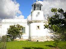 Capo Vaticano Lighthouse in 2010 | |
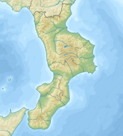 Calabria | |
| Location |
Capo Vaticano Ricadi Calabria Italy |
|---|---|
| Coordinates | 38°37′09.8″N 15°49′43.3″E / 38.619389°N 15.828694°E |
| Year first constructed | 1885 |
| Construction | masonry tower |
| Tower shape | cylindrical tower with balcony and lantern |
| Markings / pattern | white tower, metallic grey lantern dome |
| Height | 8 metres (26 ft) |
| Focal height | 108 metres (354 ft) |
| Current lens |
type OR 500 focal length: 250 mm |
| Light source | mains power |
| Intensity | 1,000 w |
| Range |
main: 24 nautical miles (44 km; 28 mi) reserve: 18 nautical miles (33 km; 21 mi) |
| Characteristic | Fl (4) W 20s. |
| Admiralty number | E1762 |
| NGA number | 9704 |
| ARLHS number | ITA-047 |
| Italy number | 2708 E.F. |
| Managing agent | Marina Militare[1][2] |


Capo Vaticano is a wide bathing place in the Municipality of Ricadi in Calabria, Italy. The 'Cape' is formed by a particular white-gray granite, which is examined worldwide for its geologic characteristics.
Geography
The maximum altitude of the cape is about 124 meters.
The coast of Capo Vaticano starts from the Tono bay of ends in Virgin Mary bay. The most suggestive bay near the Cape is Grotticelle, which divided into beaches.
History
The famous Venetian writer Giuseppe Berto made Capo Vaticano his home, after travelling throughout Italy. "Capo Vaticano", he wrote, "is called Vatican as a Roman hill: once priests and fortune tellers searched for the future basing their predictions on birds' flights. 200 meters over the Cape there is a rock called Mantineo and in ancient Greek it means: to communicate with God. The Cape was a holy place and now it is the same".
Economy
Capo Vaticano is considered as having the ideal climate for growing Red onions from Tropea.
See also
References
- ↑ Capo Vaticano The Lighthouse Directory. University of North Carolina at Chapel Hill. Retrieved 18 August 2016
- ↑ Capo Vaticano Marina Militare. Retrieved 18 August 2016
External links
Coordinates: 38°37′19″N 15°49′56″E / 38.62194°N 15.83222°E