Cape Vincent (village), New York
| Cape Vincent, New York | |
|---|---|
| Village | |
 Cape Vincent, New York Location within the state of New York | |
| Coordinates: 44°7′40″N 76°20′0″W / 44.12778°N 76.33333°WCoordinates: 44°7′40″N 76°20′0″W / 44.12778°N 76.33333°W | |
| Country | United States |
| State | New York |
| County | Jefferson |
| Area | |
| • Total | 0.8 sq mi (2.0 km2) |
| • Land | 0.7 sq mi (1.9 km2) |
| • Water | 0.0 sq mi (0.1 km2) |
| Elevation | 262 ft (80 m) |
| Population (2010) | |
| • Total | 726 |
| Time zone | Eastern (EST) (UTC-5) |
| • Summer (DST) | EDT (UTC-4) |
| ZIP code | 13618 |
| Area code(s) | 315 |
| FIPS code | 36-12353 |
| GNIS feature ID | 0945801 |
Cape Vincent is a village in Jefferson County, New York, United States. The population was 726 at the 2010 census.
The Village of Cape Vincent is in the northern part of the Town of Cape Vincent and is northwest of Watertown.
History
The area was formerly controlled by the Onondaga tribe.
French missionaries and explorers passed through the area in the middle of the 17th century.
The Town of Cape Vincent was originally part of the Town of Lyme.
In 1849 the Town of Cape Vincent separated from the Town of Lyme.
The Village of Cape Vincent was incorporated in 1853. At the time of its incorporation the Village of Cape Vincent had a population of 1218.
By the end of the 19th century, the area was becoming a vacation land due to the nearby Thousand Islands.
The Levi Anthony Building, Aubertine Building, John Borland House, Broadway Historic District, James Buckley House, E. K. Burnham House, Duvillard Mill, First Presbyterian Society of Cape Vincent, Fort Haldimand Site, Jean Philippe Galband du Fort House, Glen Building, Vincent LeRay House, Lewis House, Roxy Hotel, Cornelius Sacket House, General Sacket House, St. John's Episcopal Church, St. Vincent of Paul Catholic Church, and Otis Starkey House are listed on the National Register of Historic Places.[1][2]
Geography
According to the United States Census Bureau, Cape Vincent has a total area of 0.8 square miles (1.9 km²), of which, 0.7 square miles (1.9 km²) of it is land and 0.04 square miles (0.1 km²) of it (2.67%) is water.
Cape Vincent is on the south bank of the St. Lawrence River.
Demographics
| Historical population | |||
|---|---|---|---|
| Census | Pop. | %± | |
| 1840 | 500 | — | |
| 1860 | 1,026 | — | |
| 1870 | 1,269 | 23.7% | |
| 1880 | 1,361 | 7.2% | |
| 1890 | 1,324 | −2.7% | |
| 1900 | 1,310 | −1.1% | |
| 1910 | 1,155 | −11.8% | |
| 1920 | 913 | −21.0% | |
| 1930 | 898 | −1.6% | |
| 1940 | 931 | 3.7% | |
| 1950 | 812 | −12.8% | |
| 1960 | 770 | −5.2% | |
| 1970 | 820 | 6.5% | |
| 1980 | 785 | −4.3% | |
| 1990 | 683 | −13.0% | |
| 2000 | 760 | 11.3% | |
| 2010 | 726 | −4.5% | |
| Est. 2015 | 741 | [3] | 2.1% |
As of the census[5] of 2000, there were 760 people, 348 households, and 209 families residing in the village. There is one local bank (Citizens' Bank of Cape Vincent), a small museum, a post office (ZIP 13618), an independent telephone exchange and a few small stores.
The population density was 1,037.5 people per square mile (402.0/km²). There were 502 housing units at an average density of 685.3 per square mile (265.5/km²). The racial makeup of the village was 98.68% White, 0.13% Black or African American, 0.13% Asian, and 1.05% from two or more races. Hispanic or Latino of any race were 0.53% of the population.
There were 348 households out of which 24.1% had children under the age of 18 living with them, 43.7% were married couples living together, 12.4% had a female householder with no husband present, and 39.7% were non-families. 35.9% of all households were made up of individuals and 20.1% had someone living alone who was 65 years of age or older. The average household size was 2.16 and the average family size was 2.77.
In the village the population was spread out with 22.2% under the age of 18, 5.8% from 18 to 24, 23.7% from 25 to 44, 24.1% from 45 to 64, and 24.2% who were 65 years of age or older. The median age was 43 years. For every 100 females there were 83.6 males. For every 100 females age 18 and over, there were 81.8 males.
The median income for a household in the village was $31,833, and the median income for a family was $38,571. Males had a median income of $31,538 versus $23,125 for females. The per capita income for the village was $17,492. About 12.7% of families and 16.4% of the population were below the poverty line, including 27.3% of those under age 18 and 14.1% of those age 65 or over.
Transportation
New York State Route 12E passes through the village.
Privately owned Horne's Ferry, the only international ferry in the region, runs from May to October to Cape Vincent from "Horne's Point" (Point Alexandria) on Wolfe Island, Ontario, Canada) in the Thousand Islands. The capacity is about twelve cars. The family-owned ferry has been running since 1802 when they were first licensed to operate between Wolfe Island and Cape Vincent as well as Wolfe Island and Kingston, Ontario. The cost as of 2013 is US$15 for one car and driver.
Another ferry on the opposite side of Wolfe Island runs year-round free of charge and completes the crossing between Marysville and Kingston. The total time for both ferry crossings is a little over an hour.
Beginning in April 1852, the Cape Vincent branch of the Rome, Watertown and Ogdensburg Railroad conveyed both passengers and freight between the waterfront and Watertown (and on to Rome) via Chaumont and Brownville. This route was a vital link from the southern part of the state to the ferry terminal to Canada. However, its importance within the RW&O was reduced with the company's acquisition of the Utica and Black River Railroad (with its depot in Clayton) in 1886. In 1895, a storm blew down the Cape Vincent station building, killing two inside. From the early part of the 20th century onward, traffic decreased until passenger service was ended in March 1936, with freight following in the early 1950s. The second and final station building, having served its original purpose for over 40 years, still stands on the waterfront; it now functions as the offices of Anchor Marina.
Famous residents
Pierre-François Réal, Minister of police under Emperor Napoleon Bonaparte.
Delos B. Sackett, a career U.S. Army officer who was a general in the Union Army during the American Civil War.
References
- ↑ National Park Service (2010-07-09). "National Register Information System". National Register of Historic Places. National Park Service.
- ↑ "National Register of Historic Places Listings". Weekly List of Actions Taken on Properties: 2/04/13 through 2/08/13. National Park Service. 2013-02-15.
- ↑ "Annual Estimates of the Resident Population for Incorporated Places: April 1, 2010 to July 1, 2015". Retrieved July 2, 2016.
- ↑ "Census of Population and Housing". Census.gov. Archived from the original on May 11, 2015. Retrieved June 4, 2015.
- ↑ "American FactFinder". United States Census Bureau. Archived from the original on 2013-09-11. Retrieved 2008-01-31.
Bibliography
- History of Cape Vincent, Cape Vincent Historical Museum (2002).
External links
- Village of Cape Vincent Information
- Cape Vincent History
- Village of Cape Vincent - Official Website
- Town of Cape Vincent - Official Website
- Cape Vincent Visitors Guide
- RW&O Railroad in Cape Vincent
Municipalities and communities of Jefferson County, New York, United States | ||
|---|---|---|
| City | 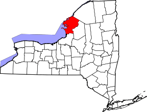 | |
| Towns | ||
| Villages | ||
| CDPs |
| |
| Hamlets | ||