Cantonment Thana
Not to be confused with Dhaka cantonment, one of several military establishments in Dhaka, headquarters of the Bangladesh Armed Forces.
| Cantonment ক্যান্টনমেন্ট | |
|---|---|
| Thana | |
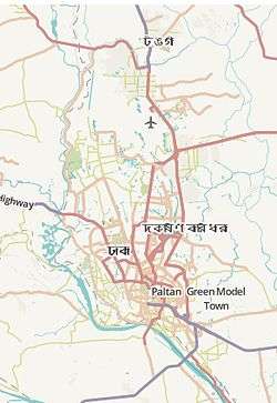 Cantonment Location in Dhaka | |
| Coordinates: 23°49.3′N 90°24.5′E / 23.8217°N 90.4083°ECoordinates: 23°49.3′N 90°24.5′E / 23.8217°N 90.4083°E | |
| Country |
|
| Division | Dhaka Division |
| District | Dhaka District |
| Area | |
| • Total | 14.47 km2 (5.59 sq mi) |
| Elevation[1] | 23 m (75 ft) |
| Population (2001) | |
| • Total | 117,464 |
| • Density | 3,923/km2 (10,160/sq mi) |
| Time zone | BST (UTC+6) |
| Website |
bangladesh |
Cantonmen Thanat (Bengali: ক্যান্টনমেন্ট) is a Thana of Dhaka district in the Division of Dhaka, Bangladesh. It includes the Army Headquarters, Naval Headquarters and the Air Force Headquarters. Cantonment Thana was formed in 1976.[2]
Geography
Cantonment is located at 23°49′20″N 90°24′30″E / 23.8222°N 90.4083°E. It has 36540 units of household and total area 14.47 km².[2]
Demographics
At the 1991 Bangladesh census, Cantonment had a population of 117,464, of whom 109,817 were aged 18 or older.[3] Males constituted 55.53% of the population, and females 44.47%. Cantonment had an average literacy rate of 68% (7+ years), against the national average of 32.4%.[4]
See also
References
- ↑ "Geographic coordinates of Dhaka, Bangladesh". DATEANDTIME.INFO. Retrieved 7 July 2016.
- 1 2 Ahmed, Syed Shabbir (2012). "Cantonment Thana". In Islam, Sirajul; Jamal, Ahmed A. Banglapedia: National Encyclopedia of Bangladesh (Second ed.). Asiatic Society of Bangladesh.
- ↑ "Bangladesh – Dhaka Statistical Metropolitan Area". Retrieved 7 July 2011.
- ↑ "Population Census Wing, BBS.". Archived from the original on 27 March 2005. Retrieved 10 November 2006.
This article is issued from Wikipedia - version of the 9/9/2016. The text is available under the Creative Commons Attribution/Share Alike but additional terms may apply for the media files.