Canaan Valley
| Canaan Valley | |
| National Natural Landmark | |
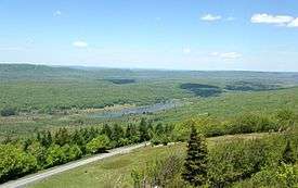
 View of the southern end of Canaan Valley from atop Harmon Knob. | |
| Country | United States |
|---|---|
| State | West Virginia |
| County | Tucker |
| Elevation | 3,200 ft (975.4 m) |
| Coordinates | 39°07′36″N 79°22′41″W / 39.12667°N 79.37806°WCoordinates: 39°07′36″N 79°22′41″W / 39.12667°N 79.37806°W |
| Area | 25,000 acres (10,117.1 ha) approximately |
| Established | December 1974 [1] |
| Owner | USDA Forest Service, US Fish and Wildlife Service, West Virginia Division of Natural Resources and private owners |
| IUCN category | III - Natural Monument |
| Nearest city | Davis, West Virginia |
 Location of Canaan Valley in West Virginia
| |
| Website: Canaan Valley | |
Canaan Valley (local /kəˈneɪn/) is an oval, bowl-like upland valley in northeastern Tucker County, West Virginia, USA. Within it are extensive wetlands and the headwaters of the Blackwater River which spills out of the valley at Blackwater Falls. It is a well-known and partially undeveloped scenic attraction and tourist draw, associated with the Canaan Valley Resort State Park and the Blackwater Falls State Park.
Canaan Valley was designated a National Natural Landmark in 1974.[1] The National Park Service citation indicates that the Valley is "a splendid 'museum' of Pleistocene habitats ... contain[ing] ... an aggregation of these habitats seldom found in the eastern United States. It is unique as a northern boreal relict community at this latitude by virtue of its size, elevation and diversity." Since 1994, almost 70% of the Valley has become the Canaan Valley National Wildlife Refuge, the nation's 500th National Wildlife Refuge.[2]
The local pronunciation of "Canaan" is /kəˈneɪn/, rather than the conventional /ˈkeɪnən/ for the Biblical region from which the area takes its name.
Geography
The Valley, nestled among the higher ranges of the Allegheny Mountains, is about 13 miles (21 km) long and 3 miles (4.8 km) to 5 miles (8.0 km) wide. It is defined by Canaan Mountain to the west and Cabin Mountain to the east. The Valley encompasses approximately 25,000 acres (although the greater Valley ecosystem is sometimes considered to consist of about 36,000 acres). The average valley floor elevation is 3,200 feet (980 m) above sea level, making it the highest sizable valley east of the Mississippi River.[3] The surrounding mountains extend upward an additional 1,250 feet (400 m) to 4,450 ft. (1,356 m) at the summit of Weiss Knob on the southeastern rim of the valley.
The Blackwater River originates in the southern part of the Valley. The Falls of the Blackwater represent part of a water gap through which the river exits the Valley between Brown and Canaan Mountains before cascading through Blackwater Canyon.
Geology
Canaan Valley — like the very similar Burke's Garden in Virginia — is a southern "muskeg" occupying an anticline valley.[4] The Valley itself is carved into the low dome of sedimentary rock known as the Blackwater Anticline, exposing the soft shales of the Mauch Chunk Formation. In the Canaan Valley region, the Blackwater River began carving into the underlying sedimentary rock layers of Mississippian and Pennsylvanian age (345–270 millions years ago) about one million years ago. The hard, erosion-resistant Pottsville Formation of sandstones is the higher layer supporting the mountains surrounding Canaan Valley and also constitutes the sharp rim of the nearby Blackwater Gorge. Tombstone-like outcroppings of Greenbrier Limestone are also exposed at places along the Valley floor. A relatively high area within the Valley – the Central Pocono Ridge – is composed of the erosion-resistant Pocono Group sandstone.
Climate
Because of its relatively high elevation of 3,200 feet, Canaan Valley has a cooler, moister climate than surrounding areas at lower altitudes.
Summers are cool and humid with afternoon maximum temperatures averaging in the mid 70s °F. Summer morning minimum temperatures average in the low 50s °F. Due to its altitude and "frost hollow" topography, extreme minimum temperatures below freezing (20s °F) have been recorded in every month of the year. The average growing season of about 95 days is shorter than in Fairbanks, Alaska in interior central Alaska.
Winters are typically cold and snowy with an average winter producing 134 inches (340 cm) of snowfall. The largest snowfall of 257 inches (650 cm) was recorded in 1995–96 winter. Even in the mildest of winters, over 5 feet (25 cm) of snow falls. Snow pack usually reaches a maximum depth of about 2 feet plus (0.7 m) in late February. In exceptionally cold snowy winters, packs can exceed 4 feet (1.2 m) in depth in the woods.
Due to its proximity to both the warm Gulf of Mexico and frigid interior northern Canada, periods of warm above freezing conditions alternate with frigid temperatures. This results in periods of rain and snow even during the coldest months. This part of the climate normally holds snow depth on the ground to below what it would be without rainfall occurring.
Canaan Valley's elevation and geographic location allows it to receive significant upslope snow (Orographic lift) regularly during the winter, particularly during prolonged periods of northwesterly winds coming off of the Great Lakes. Such synoptic situations can generate prolonges blizzard conditions. Located along the spine of the Central Appalachian Mountains, the Valley is often near the southwestern extreme of Nor'easters, occasionally getting blizzards from strong, Atlantic moisture-laiden, easterly winds.
| Climate data for Canaan Valley, West Virginia (station elevation 3,250ft) | |||||||||||||
|---|---|---|---|---|---|---|---|---|---|---|---|---|---|
| Month | Jan | Feb | Mar | Apr | May | Jun | Jul | Aug | Sep | Oct | Nov | Dec | Year |
| Record high °F (°C) | 66 (19) |
66 (19) |
80 (27) |
85 (29) |
86 (30) |
95 (35) |
96 (36) |
93 (34) |
95 (35) |
82 (28) |
75 (24) |
68 (20) |
96 (36) |
| Average high °F (°C) | 35.9 (2.2) |
38.2 (3.4) |
46.9 (8.3) |
58.8 (14.9) |
67.8 (19.9) |
74.7 (23.7) |
77.8 (25.4) |
76.7 (24.8) |
70.7 (21.5) |
60.9 (16.1) |
49.0 (9.4) |
39.0 (3.9) |
58.0 (14.4) |
| Average low °F (°C) | 16.9 (−8.4) |
18.0 (−7.8) |
24.8 (−4) |
33.8 (1) |
42.3 (5.7) |
49.0 (9.4) |
53.3 (11.8) |
51.6 (10.9) |
45.6 (7.6) |
35.9 (2.2) |
28.4 (−2) |
20.1 (−6.6) |
35.0 (1.7) |
| Record low °F (°C) | −27 (−33) |
−26 (−32) |
−19 (−28) |
−2 (−19) |
14 (−10) |
24 (−4) |
27 (−3) |
25 (−4) |
18 (−8) |
5 (−15) |
−14 (−26) |
−21 (−29) |
−27 (−33) |
| Average precipitation inches (mm) | 4.40 (111.8) |
4.07 (103.4) |
4.90 (124.5) |
4.26 (108.2) |
4.95 (125.7) |
4.92 (125) |
4.92 (125) |
4.58 (116.3) |
3.64 (92.5) |
3.41 (86.6) |
3.93 (99.8) |
4.17 (105.9) |
52.15 (1,324.6) |
| Average snowfall inches (cm) | 29.7 (75.4) |
27.4 (69.6) |
24.5 (62.2) |
8.8 (22.4) |
0.4 (1) |
0 (0) |
0 (0) |
0 (0) |
0 (0) |
2.0 (5.1) |
11.8 (30) |
23.9 (60.7) |
128.5 (326.4) |
| Source: http://www.wrcc.dri.edu/cgi-bin/cliMAIN.pl?wv1393 | |||||||||||||
History
Prehistory and settlement

Canaan Valley and surrounding areas were strongly impacted by the southward advance of glaciers some 15,000 years ago. Although the glaciers themselves did not extend into the area, this climatic change resulted in a very cool, moist environment that was forest-unfriendly. Later, as the ice receded, many cold-adapted plant species remained behind and survived due to the high elevation. Soon, however, this tundra-like vegetation was largely crowded out by the growth of an extraordinarily dense climax red spruce forest, intermixed with balsam fir and hardwoods.
The first whites to see Canaan Valley were likely the surveyors of the famous Fairfax Line who crossed Canaan Mountain in 1746 under conditions of extreme difficulty.[5] According to a local tradition, a German settler named Henry Fansler, who was migrating from the Shenandoah Valley, viewed the valley from Cabin Mountain in April 1800 and exclaimed “Besiehe das Land Canaan” [“Behold the Land of Canaan”].[6]:593 Fansler and his family hacked out a living on Freeman Creek in the Valley for three years before the harsh winters and poor farming potential forced them to move to the mouth of the Blackwater a few miles away. Fansler was the first Canaan settler whose name is known, although there is known to have been an earlier abortive homesteader in the 1770s or ‘80s who left descendants elsewhere in the county.[7]:378
The rugged and remote "High Allegheny" region (what is now east-central West Virginia), including the Valley, was bypassed by development for many decades. As large-scale settlement occurred to its north, south and west the region remained relatively wild. In the 19th Century, the Valley was a last refuge for many of the large mammal species that were being exterminated from the eastern United States. In about 1843, for example, three elk were killed in Canaan Valley by members of the Flanagan and Carr families, local settlers who habitually hunted there. These were likely the last elk found wild in the region that later became West Virginia.[8]
The earliest settler to make a successful and permanent livelihood in the Valley came more than 60 years after Fansler when Solomon W. Cosner began living at Fansler’s old homestead in 1864.[7]:378-379 The country was described at that time as one of “…original forests [which…] is swampy, but, as soon as the timber is removed, the water dries up… Water stands in horse tracks in the woods.” Cosner, a Civil War veteran known as the “Pioneer of Canaan”, was a noted bear hunter. He and his sons were said to have killed more than 500 bears in Canaan Valley (as well as countless deer, two panthers and a wolf). Other families arrived to settle in the Valley in the 1870s.
In 1883, a Virginia adventurer, former Texas cowboy and land speculator named Charles R. Ruffin bought 5,000 acres (20 km2) of the Valley and organized the “Canaan Valley Blue Grass & Improvement Company”, but his scheme to create a vast and profitable cattle ranch came to nothing.[7]:488-489,[6]:595
Logging and wildfires
Logging of the surrounding mountains was extensive in the 1880s and '90s, but impenetrable understories of rhododendron made passage through the Valley floor almost impossible until the advent of a logging railroad in 1915. The productivity of the timber stands extracted from the Valley floor between 1888 and 1922 (when the last virgin timber was removed) was twice that of similar stands within the state.
By the 1920s, the Babcock Lumber and Boom Company had virtually exhausted its commercial prospects in the Valley. In 1923, the West Virginia Power and Transmission Company (WVPTC, later called Allegheny Power Systems), bought 13,230 acres (53.5 km2) in the northern half of the Valley from Babcock with a long-range plan to construct a hydroelectric power plant that would flood much of the Valley[9]:212 The WVPTC was not, of course, motivated by any preservationist or environmentalist impulses, but this land purchase was decisive for the fate of the Valley and the power company proved an unwitting guardian of the natural wetlands from development. According to Michael—a wildlife biologist with 30 years experience in the Valley—had this purchase not occurred by a public utility at a time when the scientific and environmental value of wetland was not yet recognized, the northern Valley would undoubtedly have been drained and developed by commercial and private interests in the 1950s and '60s, as happened in the southern Valley.
Serious accidents, even fatal ones, were not uncommon in the logging industry in West Virginia in its heyday. A particularly noteworthy one occurred on 5 February 1924 in Canaan Valley when Babcock's Engine #4 wrecked and killed superintendent Fred V. Viering.[10]
Recovery and development
In 1920, the southern third of the Valley was included in the newly established Monongahela National Forest, the first attempt to restore the forests that the previous generation had cut down. The logging railroads in the Valley were abandoned, then the rails were pulled up in 1925. The outside world intrude again in 1932, however, in the form of West Virginia Route 32 which bisects the southern end of the Valley, connecting Davis to Harman. This is the only north-south highway in the Valley and it was along this route that the later development of the 20th century occurred. Electrification came to this part of the Valley in 1938.[9]:221
In the late 1930s, the Civilian Conservation Corps undertook as one of its projects the reforestation of Canaan Mountain. In areas where there was no soil at all to work with, trucks were run from the Valley continuously bringing dark muck soil to the mountaintop. Spruce seedlings were packed in, each requiring a bushel or two of soil, and by the 1940s a new spruce forest had been established on the slopes overlooking the Valley.[11] In 1943–44, as part of the West Virginia Maneuver Area, the U.S. Army used the Canaan Valley area as a practice artillery and mortar range and maneuver area before troops were sent to European Theater of Operations to fight in World War II.
Beginning in 1950, the Ski Club of Washington, DC was developing ski slopes on the Valley side of Bald Knob of Cabin Mountain[6]:595-596 Within the decade, a 3,600-foot (1,100 m) slope on Cabin Mountain and a 3,900 feet (1,200 m) slope on Weiss Knob had been developed. Because of its protection from the sun, snow on that side of the mountain often remains until April or later.
In the early 1970s, Canaan Valley Resort State Park was created at the southern end of the Valley in an attempt to further develop a ski industry in the state. An 18-hole golf course was also constructed there at this time.
Controversy and preservation
In 1970, Allegheny Power requested permits for the long-anticipated hydroelectric facility in the Valley. This power plant would have supplied electricity to major metropolitan areas of the northeastern United States. The proposal involved damming the Blackwater River with consequent flooding of about 8,000 acres (32 km2), including all of the wetland — roughly 25% of the Valley floor. Public objections were raised and, in the midst of the furor, the Valley was designated a National Natural Landmark by the U.S. Department of the Interior in December 1974. In 1977, the Federal Power Commission issued a license to Allegheny for construction of a pumped storage hydroelectric project, formally known as the Davis Power Project. Contentious public hearings ensued and the following year the project was denied a Clean Water Act permit by the U.S. Army Corps of Engineers. The Corps' decision cited adverse impacts upon the Valley's wetlands, a relatively new concept at the time. Allegheny appealed the Corps' decision to the U.S. Court of Appeals which ruled that a Clean Water Act permit was in fact required for work to commence. The adverse ruling by the appeals court was itself appealed to the U.S. Supreme Court which in 1988 declined to hear the case. This represented the final nail in the coffin of the Davis Power Project.[9]:221-222
In 1994, about 86 acres (350,000 m2) of the Valley were purchased by the U.S. Fish and Wildlife Service to establish a National Wildlife Refuge, the nation's 500th. In 2002, Allegheny – having kept development of most of the Valley at bay since its 1923 land purchase – finally sold its 12,000 acres (49 km2) to the government to be added to the Refuge. With additional acquisitions, the present Canaan Valley National Wildlife Refuge is almost 17,000 acres (69 km2) in extent.[12]
Ecology
Wetlands and boreal plants

Canaan Valley shares much of the plant and animal life characteristic of the rest of the state, but its 40 botanical communities also include species otherwise found only in sub-arctic bogs and conifer forests much further north. It has been described by ecologists and conservationists as "a bit of Canada gone astray". The Valley includes several habitat types, but particularly noteworthy are its extensive wetlands, which are the largest in the entire central and southern Appalachian region; they form the second largest inland wetland area in the United States.[3] These 8,400 or so acres of shrub swamp and bog represent approximately 40% of the wetland found in the state of West Virginia.
Flora
Over 580 plant species have been documented in the Valley, notably various mosses, sedges and heathers, the large cranberry and the Canadian blueberry. Also present are the sundew, marsh marigold, jack-in-the-pulpit, starflower and Canadian lily-of-the-valley. Late August experiences impressive blooms of cotton grass, a sedge otherwise found mostly in Alaska and Canada.
Fauna
More than 280 animal species have been recorded in the Valley.
Mammals
The valley and surrounding highlands provide some of the most southern pockets of snowshoe hare habitat. Other local mammals include beavers, muskrats, raccoons, opossums, and grey and red squirrels. Seen far less frequently are black bears, bobcats, coyotes, and red foxes. Of special note are large groups of white-tailed deer which can often be seen from the main roads. The deer have become so conditioned to human presence that they are no longer frightened; feeding and interacting with the deer is strongly discouraged.
Birds
Birdlife is prolific, especially those species attracted by the valley's wetlands. These include ducks (wood ducks, mallards, black ducks), Canada geese and the great blue heron. These wetlands are the southernmost nesting site for the American bittern. Notable migratory songbirds finding seasonal homes in the valley include the golden-winged warbler, scarlet tanager, indigo bunting, and Canada warbler. Raptors include red-tailed hawks, goshawks and the occasional peregrine falcon and bald eagle.
Fish
Smallmouth bass and various other sunfish are found in the upper Blackwater River. Native brook trout and introduced rainbow trout are also found in some of the cold, clean streams of the area.
Tourism and recreation
The Valley's unique climatic and natural features attract a steady flow of outdoor recreationalists. Camping, hiking, fishing (trout, bass), cross-country and downhill skiing, leaf-peeping, and wildlife viewing are popular outdoor activities. Upland game bird hunting (woodcock, ruffed grouse, common snipe, wild turkey) has long been popular in the Valley and is still permitted, even in the NWR, within season.
In addition to the two state parks and one wildlife refuge, the valley is home to two Alpine ski resorts (Canaan Valley Ski Resort and Timberline Four Seasons Resort) and one Nordic ski area (White Grass Touring Center).
See also
References
Citations
- 1 2 "Canaan Valley". National Park Service. Retrieved 2008-04-20.
- ↑ "Canaan Valley National Wildlife Refuge". www.fws.gov. Retrieved 2009-02-25.
- 1 2 Phillips, John (2001). Ski and Snowboard America - Mid-Atlantic: The Complete Guide to Downhill Skiing, Snowboarding, Cross Country Skiing, Snow Tubing, and More Throughout the Mid-Atlantic Region. Guilford, Connecticut: Globe Pequot Press. ISBN 0-7627-0845-X.
- ↑ Brooks, Maurice (1965), The Appalachians (Series: The Naturalist's America), Illustrated by Lois Darling and Lo Brooks, Boston: Houghton Mifflin Company, pp. 116–117.
- ↑ Lewis, Thomas, The Fairfax Line: Thomas Lewis's Journal of 1746; Footnotes and index by John Wayland, Newmarket, Virginia: The Henkel Press, p. 32 of the 1925 reprint edition: “Our horses and often our Selves often fell into Clefts & Cavities without Seeing the danger Before we felt the Effects of it... for in Striving to Evade a Seen Dangerous or Bad place we often fell into a worse.”
- 1 2 3 Fansler, Homer Floyd (1962), History of Tucker County, West Virginia, Parsons, West Virginia: McClain Printing Company
- 1 2 3 Maxwell, Hu (1884). History of Tucker County, West Virginia, From the Earliest Explorations and Settlement to the Present Time, etc… Journal Printing House, Kingwood, W.Va. (Reprinted, McClain Printing Company, Parsons, W.Va., 1971 and 1993).
- ↑ Maxwell, Hu (1898). The History of Randolph County, West Virginia, From its Earliest Settlement to the Present, The Acme Publishing Company, Morgantown, W.Va. (Reprinted, McClain Printing Company, Parsons, W.Va., 1961). p. 300.
- 1 2 3 Michael, Edwin Daryl (2002), A Valley Called Canaan: 1885-2002, Parsons, West Virginia: McClain Printing Company.
- ↑ Teter, Don (2011), Goin' Up Gandy: A History of the Dry Fork Region of Randolph and Tucker Counties, West Virginia, 2nd Edition; Parsons, West Virginia: McClain Printing Company, p. 44, n20. (The 1st edition was published 1977.)
- ↑ Brooks, Op. cit., pg 129.
- ↑ Steelhammer, Rick (2009-01-28). "Canaan Valley Refuge adds 120-acre tract". Charleston Gazette. Archived from the original on 2009-01-28. Retrieved 2009-01-28.
Other sources
- Allard, H.A. and E.C. Leonard (1952), "Canaan and Stony River Valleys of West Virginia, Their Former Magnificent Spruce Forests, Their Vegetation and Floristics Today,", Castanea 17:1-60.
- Kennedy, Philip Pendleton (1853), The Blackwater Chronicle, A Narrative of an Expedition into the Land of Canaan in Randolph County, Virginia, Redfield, New York.
- Strother, David Hunter (1855), The Virginia Canaan, Harper's Magazine, 8:18-36.
- Fortney, Ronald H. (1993), “Canaan Valley – An Area of Special Interest within the Upland Forest Region”, Chapter 4 in: Upland Forests of West Virginia, Stephen L. Stephenson, editor; Parsons, West Virginia: McClain Printing Company.
- Preble, Jack (1971), Land of Canaan, Plain Tales from the Mountains of West Virginia, Parsons, West Virginia: McClain Printing Company, 1st ed., 1960; 2nd ed., 1965, 3rd ed., 1971.
- Freshwater Institute and West Virginia Audubon Council (n.d. [but 1980s]), The Canaan Valley: A National Treasure, 12 minute educational film.
- Ludlum, J.C., and Arkle, Jr., T. (1971), Blackwater Falls State Park and Canaan Valley State Park: Resources, Geology and Recreation, West Virginia Geological and Economic Survey, State Park Series Bulletin 6, 60 p.
- Matchen, D.L., Fedorko, N., and Blake, Jr., B.M. (1998), Geology of Canaan Valley, 1:24,000 scale (Map, with explanation text).
- Venable, Norma Jean (1990), Canaan Valley, West Virginia University Extension Service, Morgantown, West Virginia.