Canaan, New Hampshire
| Canaan, New Hampshire | ||
|---|---|---|
| Town | ||
|
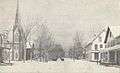
Church Street in 1907 | ||
| ||
| Motto: "Land of Milk and Honey" | ||
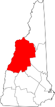
 Location in Grafton County, New Hampshire | ||
| Coordinates: 43°38′48″N 72°00′37″W / 43.64667°N 72.01028°WCoordinates: 43°38′48″N 72°00′37″W / 43.64667°N 72.01028°W | ||
| Country | United States | |
| State | New Hampshire | |
| County | Grafton | |
| Incorporated | 1761 | |
| Government | ||
| • Board of Selectmen |
Scott Borthwick, Chair David McAlister Al Posnanski | |
| Area | ||
| • Total | 55.0 sq mi (142.5 km2) | |
| • Land | 53.2 sq mi (137.8 km2) | |
| • Water | 1.8 sq mi (4.7 km2) 3.31% | |
| Elevation | 945 ft (288 m) | |
| Population (2010) | ||
| • Total | 3,909 | |
| • Density | 71/sq mi (27/km2) | |
| Time zone | Eastern (UTC-5) | |
| • Summer (DST) | Eastern (UTC-4) | |
| ZIP code | 03741 | |
| Area code(s) | 603 | |
| FIPS code | 33-08980 | |
| GNIS feature ID | 0873557 | |
| Website |
www | |


Canaan is a town in Grafton County, New Hampshire, United States. The population was 3,909 at the 2010 census.[1] It is the location of Mascoma State Forest. Canaan is home to the Cardigan Mountain School, the town's largest employer.
The main village of the town, where 524 people resided at the 2010 census,[2] is defined as the Canaan census-designated place (CDP), and is located at the junction of U.S. Route 4 with New Hampshire Route 118.
History
Chartered in 1761 by Governor Benning Wentworth, the town was named after the hometown of many early settlers, Canaan, Connecticut. (It had been named by Puritans for the biblical land of Canaan.) It was settled in the winter of 1766-1767 by John Scofield, who arrived with all his belongings on a hand sled. The land was filled with rocks, making agriculture difficult. The town constructed a broad road for its main street on a stretch of level land.[3]
In 1828 attorney George Kimball helped organize building the town's Congregational church. He was among the New England abolitionists who founded the Noyes Academy in March 1835, one of the first in the region to admit students of all races. It opened with 28 white students, drawn largely from local families, and 17 black students; most of the latter came from outside the town and across the Northeast. Many local residents opposed bringing blacks into the town. On August 10, 1835, five hundred white men from Canaan and nearby towns used "nearly 100 yoke of oxen" to pull the building off its foundation, then burned it. Fearing for their safety, the black students left town, as did Kimball, who moved to Alton, Illinois.[4]
The Canaan Union Academy was built on the site. Limited to white students, it operated for about 20 years. Later residents sympathetic to fugitive slaves operated a station of the Underground Railroad to help the people reach Canada or settle in New England.[3]
The Northern Railroad (predecessor of the Boston & Maine Railroad) was constructed to the town in 1847, spurring development. Water powered mills were built on the streams. By 1859, the population had reached 1,682, and Canaan had one gristmill, three lath and clapboard mills, and one tannery.[5]
Canaan was the site of a famous train wreck on September 15, 1907. Four miles west of Canaan Station, the southbound Quebec to Boston express, crowded with passengers returning from the Sherbrooke Fair, collided head-on with a northbound Boston & Maine freight train. Twenty-five people died, and an equal number were seriously injured. The accident was "due to a mistake in train dispatcher's orders."[6]
On June 2, 1923, the Great Canaan Fire burned 48 homes and businesses, destroying the heart of Canaan Village (East Canaan).
-

Old North Church c. 1915
-
Canaan Village c. 1915 (before 1923 fire)
-

B. & M. R. R. depot in 1911
Geography
According to the United States Census Bureau, the town has a total area of 55.0 square miles (142 km2), of which 53.2 sq mi (138 km2) is land and 1.8 sq mi (4.7 km2) is water, comprising 3.31% of the town.[1] Canaan is drained by the Indian River and Mascoma River. Canaan Street Lake is in the center, and Goose Pond is in the northwest.
The town center lies in the valley of the Indian River (a tributary of the Mascoma River) at the base of Mount Cardigan, which lies to the east in the neighboring town of Orange. A mountain road leads from Canaan to a trailhead in Cardigan Mountain State Forest, where hiking trails on the west slope of the mountain lead to the bare-rock summit. The highest point in Canaan is the top of an unnamed ridge (approximately 2,270 feet (690 m) above sea level) in the northeast corner of town, overlooking Derby Pond.
Canaan lies almost fully within the Connecticut River watershed, except for a tiny part of the northeast of the town, which is in the Merrimack River watershed.[7]
The town is crossed by U.S. Route 4 and New Hampshire Route 118.
Demographics
| Historical population | |||
|---|---|---|---|
| Census | Pop. | %± | |
| 1790 | 483 | — | |
| 1800 | 835 | 72.9% | |
| 1810 | 1,094 | 31.0% | |
| 1820 | 1,198 | 9.5% | |
| 1830 | 1,428 | 19.2% | |
| 1840 | 1,576 | 10.4% | |
| 1850 | 1,682 | 6.7% | |
| 1860 | 1,762 | 4.8% | |
| 1870 | 1,877 | 6.5% | |
| 1880 | 1,762 | −6.1% | |
| 1890 | 1,417 | −19.6% | |
| 1900 | 1,444 | 1.9% | |
| 1910 | 1,408 | −2.5% | |
| 1920 | 1,236 | −12.2% | |
| 1930 | 1,301 | 5.3% | |
| 1940 | 1,377 | 5.8% | |
| 1950 | 1,465 | 6.4% | |
| 1960 | 1,507 | 2.9% | |
| 1970 | 1,923 | 27.6% | |
| 1980 | 2,456 | 27.7% | |
| 1990 | 3,045 | 24.0% | |
| 2000 | 3,319 | 9.0% | |
| 2010 | 3,909 | 17.8% | |
| Est. 2015 | 3,891 | [8] | −0.5% |

As of the census[10] of 2010, there were 3,909 people, 1,588 households, and 1,105 families residing in the town. The population density was 73.5 people per square mile (28.4/km²). There were 1,930 housing units at an average density of 36.3 per square mile (14.0/km²). The racial makeup of the town was 97.1% White, 0.1% African American, 0.2% Native American, 1.0% Asian, 0.2% some other race, and 1.3% from two or more races. Hispanic or Latino of any race were 0.8% of the population.[11]
There were 1,588 households, of which 28.7% had children under the age of 18 living with them, 55.0% were headed by married couples living together, 9.4% had a female householder with no husband present, and 30.4% were non-families. 23.3% of all households were made up of individuals, and 7.6% were someone living alone who was 65 years of age or older. The average household size was 2.42, and the average family size was 2.81.[11]

In the town, the population was spread out with 20.9% under the age of 18, 6.6% from 18 to 24, 25.8% from 25 to 44, 33.7% from 45 to 64, and 12.9% who were 65 years of age or older. The median age was 42.6 years. For every 100 females there were 99.5 males. For every 100 females age 18 and over, there were 98.3 males.[11]
For the period 2007-2011, the estimated median annual income for a household in the town was $62,226, and the median income for a family was $63,930. Male full-time workers had a median income of $46,250 versus $37,287 for females. The per capita income for the town was $26,964. About 4.5% of families and 6.4% of the population were below the poverty line, including 5.7% of those under age 18 and 6.3% of those age 65 or over.[12]
In 2014 the largest ancestry groups reported in Canaan were English (17.8%), "American" (17.4%), French or French Canadian (14.2%), and Irish (12.6%).[13]
Sites of interest
- Canaan Historical Museum
- Canaan Motor Club, auto racetrack
- Northern Rail Trail
Notable people
- Daniel Blaisdell, US congressman[14]
- Henry G. Burleigh, US congressman from New York[15]
- Frank Dunklee Currier, US congressman[16]
- Joshua Smith, author (Divine Hymns, or Spiritual Songs)
References
- 1 2 "Geographic Identifiers: 2010 Demographic Profile Data (G001): Canaan town, Grafton County, New Hampshire". U.S. Census Bureau, American Factfinder. Retrieved January 22, 2013.
- ↑ "Geographic Identifiers: 2010 Demographic Profile Data (G001): Canaan CDP, New Hampshire". U.S. Census Bureau, American Factfinder. Retrieved January 22, 2013.
- 1 2 Child, Hamilton (1886). Gazetteer of Grafton County, N. H. 1709-1886. Syracuse, New York. pp. 233–234.
- ↑ Child (1886), pp. 73 and 234
- ↑ Coolidge, Austin J.; John B. Mansfield (1859). A History and Description of New England. Boston, Massachusetts. p. 432.
- ↑ "Canaan, NH Train Wreck of 1907", Reporter, 20 September 1907, hosted at Rootsweb
- ↑ Foster, Debra H.; Batorfalvy, Tatianna N.; Medalie, Laura (1995). Water Use in New Hampshire: An Activities Guide for Teachers. U.S. Department of the Interior and U.S. Geological Survey.
- ↑ "Annual Estimates of the Resident Population for Incorporated Places: April 1, 2010 to July 1, 2015". Retrieved July 2, 2016.
- ↑ "Census of Population and Housing". Census.gov. Archived from the original on May 11, 2015. Retrieved June 4, 2016.
- ↑ "American FactFinder". United States Census Bureau. Archived from the original on 2013-09-11. Retrieved 2008-01-31.
- 1 2 3 "Profile of General Population and Housing Characteristics: 2010 Demographic Profile Data (G001): Canaan town, Grafton County, New Hampshire". U.S. Census Bureau, American Factfinder. Retrieved January 22, 2013.
- ↑ "Selected Economic Characteristics: 2007-2011 American Community Survey 5-Year Estimates (DP03): Canaan town, Grafton County, New Hampshire". U.S. Census Bureau, American Factfinder. Retrieved January 22, 2013.
- ↑ "People Reporting Single Ancestry: 2010-2014 American Community Survey 5-Year Estimates (B04004); Canaan town, Grafton County, New Hampshire". American Factfinder. U.S. Census Bureau. Retrieved October 3, 2016.
- ↑ "BLAISDELL, Daniel, (1762 - 1833)". Biographical Directory of the United States Congress. Retrieved January 16, 2014.
- ↑ "BURLEIGH, Henry Gordon, (1832 - 1900)". Biographical Directory of the United States Congress. Retrieved January 16, 2014.
- ↑ "CURRIER, Frank Dunklee, (1853 - 1921)". Biographical Directory of the United States Congress. Retrieved January 16, 2014.
External links
- Town of Canaan official website
- Canaan Historical Society
- Canaan Town Library
- Cardigan Mountain School
- New Hampshire Economic and Labor Market Information Bureau Profile
- Canaan, NH Train Wreck of 1907