Cambrian Park, California
| Cambrian Park | |
|---|---|
| census-designated place | |
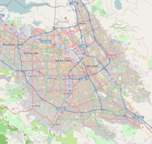 Cambrian Park Location within San Jose and Silicon Valley | |
| Coordinates: 37°15′20″N 121°55′44″W / 37.25556°N 121.92889°WCoordinates: 37°15′20″N 121°55′44″W / 37.25556°N 121.92889°W | |
| Country |
|
| State |
|
| County | Santa Clara |
| Area[1] | |
| • Total | 0.596 sq mi (1.544 km2) |
| • Land | 0.596 sq mi (1.544 km2) |
| • Water | 0 sq mi (0 km2) 0% |
| Elevation[2] | 236 ft (72 m) |
| Population (2010) | |
| • Total | 3,282 |
| • Density | 5,500/sq mi (2,100/km2) |
| Time zone | Pacific (PST) (UTC-8) |
| • Summer (DST) | PDT (UTC-7) |
| Area code(s) | 408 |
Cambrian Park is a census-designated place (CDP) and neighborhood of San Jose, a city in Santa Clara County, California, United States. Cambrian Park was never incorporated as a town (although there were efforts to do so in the early 1960s), and there was a Post Office located in the Cambrian Park Plaza. Much of the neighborhood is now part of the incorporated city of San Jose; the rest forms the CDP.
The population was 3,282 at the 2010 census.
History
The name "Cambrian Park" was used regularly since the 1950s by the then San Jose Mercury and San Jose News newspapers (now The San Jose Mercury News) to refer to a portion of the Union school and Cambrian school areas, the latter school named in the 1870s by ranch hand David Lewis of the Jeremiah D. Casey Ranch for Cambria, the Latinized name for Wales (Welsh, Cymru), the country of Lewis's birth. Due to the relative isolation of adjacent population centers within then rural Santa Clara County, place names and later, municipalities, were often defined by their public school service boundaries. These indistinct boundaries persisted until WWII, after which a rapidly expanding population and demand for municipal services resulted in more precise boundaries being established. The Cambrian Park area continues to be recognized as a distinct, partly unincorporated neighborhood bordering the cities of San Jose and Campbell and the town of Los Gatos.[3]
We and Our Neighbors women's club was established in the adjacent Union School District area in 1892, "...to promote social ties, intellectual and cultural pursuits, charitable deeds, and recreation for the farm families of the neighborhood." Their clubhouse, built in 1910, is a San Jose Historic Landmark and appears in the National Register of Historic Places.[4]
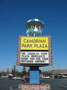
The commerce center for the Cambrian Park area has always been the Cambrian Park Plaza. Located at the crossroads of Camden and Union Avenues, the center was originally built in 1953. Today the center maintains the country charm and construction style, across over 170,000 square feet of stores. Through the years, the center has housed a mix of local shops and national brands. The iconic colorful carousel atop the center sign is currently under evaluation for designation as a historical landmark. This is of particular interest in the community as the center was sold for the first time ever in 2015, to Texas-based Weingarten Realty. [5]
Geography
Cambrian Park is located at 37°15′20″N 121°55′44″W / 37.25556°N 121.92889°W (37.255593, −121.928915).[6]
According to the United States Census Bureau, the CDP had a total area of 0.6 square miles (1.6 km2), all of it land.
Not all of the general area today considered "Cambrian Park" lies within San Jose's city limits. A large swath of the neighborhood remains an unincorporated "island" that is administered by Santa Clara County. Recent changes in annexation laws in the State of California that streamlined the process of cities acquiring neighborhoods did not affect this unincorporated area because its population was too large. Thus, if the city of San Jose ever decides to annex the "county island," the annexation must be accepted by the majority of the population of the area to be annexed.
Demographics
These figures do not include any part of Cambrian Park which has been incorporated into San Jose at the time of the census.
2010
The 2010 United States Census[7] reported that Cambrian Park had a population of 3,282. The population density was 5,503.8 people per square mile (2,125.0/km²). The racial makeup of Cambrian Park was 2,598 (79.2%) White, 26 (0.8%) African American, 29 (0.9%) Native American, 221 (6.7%) Asian, 19 (0.6%) Pacific Islander, 190 (5.8%) from other races, and 199 (6.1%) from two or more races. Hispanic or Latino of any race were 591 persons (18.0%).
The Census reported that 3,268 people (99.6% of the population) lived in households, 3 (0.1%) lived in non-institutionalized group quarters, and 11 (0.3%) were institutionalized.
There were 1,141 households, out of which 439 (38.5%) had children under the age of 18 living in them, 670 (58.7%) were opposite-sex married couples living together, 122 (10.7%) had a female householder with no husband present, 67 (5.9%) had a male householder with no wife present. There were 57 (5.0%) unmarried opposite-sex partnerships, and 10 (0.9%) same-sex married couples or partnerships. 206 households (18.1%) were made up of individuals and 88 (7.7%) had someone living alone who was 65 years of age or older. The average household size was 2.86. There were 859 families (75.3% of all households); the average family size was 3.25.
The population was spread out with 789 people (24.0%) under the age of 18, 231 people (7.0%) aged 18 to 24, 775 people (23.6%) aged 25 to 44, 1,080 people (32.9%) aged 45 to 64, and 407 people (12.4%) who were 65 years of age or older. The median age was 42.4 years. For every 100 females there were 101.1 males. For every 100 females age 18 and over, there were 102.2 males.
There were 1,179 housing units at an average density of 1,977.1 per square mile (763.4/km²), of which 909 (79.7%) were owner-occupied, and 232 (20.3%) were occupied by renters. The homeowner vacancy rate was 0.8%; the rental vacancy rate was 4.1%. 2,621 people (79.9% of the population) lived in owner-occupied housing units and 647 people (19.7%) lived in rental housing units.
2000
As of the census[8] of 2000, there were 3,258 people, 1,127 households, and 854 families residing in the CDP. The population density was 2,062.2/km² (5,322.0/mi²). There were 1,143 housing units at an average density of 723.5/km² (1,867.1/mi²). The racial makeup of the CDP was 84.87% White, 0.40% African American, 1.04% Native American, 4.11% Asian, 0.21% Pacific Islander, 4.33% from other races, and 5.03% from two or more races. Hispanic or Latino of any race were 11.63% of the population.
There were 1,127 households out of which 35.8% had children under the age of 18 living with them, 57.8% were married couples living together, 11.7% had a female householder with no husband present, and 24.2% were non-families. 16.7% of all households were made up of individuals and 6.7% had someone living alone who was 65 years of age or older. The average household size was 2.88 and the average family size was 3.20.
In the CDP the population was spread out with 25.7% under the age of 18, 7.1% from 18 to 24, 31.9% from 25 to 44, 23.5% from 45 to 64, and 11.8% who were 65 years of age or older. The median age was 38 years. For every 100 females there were 101.0 males. For every 100 females age 18 and over, there were 99.2 males.
The median income for a household in the CDP was $80,743, and the median income for a family was $89,706. Males had a median income of $59,375 versus $46,700 for females. The per capita income for the CDP was $31,942. About 4.2% of families and 5.6% of the population were below the poverty line, including 3.0% of those under age 18 and 14.1% of those age 65 or over.
References
- ↑ U.S. Census Archived 2012-07-14 at WebCite
- ↑ U.S. Geological Survey Geographic Names Information System: Cambrian Park, California
- ↑ "History of Cambrian Area". cambriancommunitycouncil.com. Cambrian Community Council. 2009. Retrieved August 12, 2015.
- ↑ "History of We and Our Neighbors". weandourneighbors.org. We and Our Neighbors. 2015. Retrieved August 12, 2015.
- ↑ "1950s Cambrian Park Plaza sold". mercurynews.com. Mercury News. 2015. Retrieved June 15, 2016.
- ↑ "US Gazetteer files: 2010, 2000, and 1990". United States Census Bureau. 2011-02-12. Retrieved 2011-04-23.
- ↑ "2010 Census Interactive Population Search: CA - Cambrian Park CDP". U.S. Census Bureau. Retrieved July 12, 2014.
- ↑ "American FactFinder". United States Census Bureau. Archived from the original on 2013-09-11. Retrieved 2008-01-31.
External links
- Cambrian Park branch of the San Jose Public Library system
- Cambrian Resident – weekly free community newspaper
Municipalities and communities of Santa Clara County, California, United States | ||
|---|---|---|
| Cities and towns | 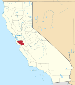 | |
| CDPs | ||
| Unincorporated communities | ||
| CCDs | ||
| Ghost towns | ||
| Bodies of water |
|  |
|---|---|---|
| Counties | ||
| Major cities | ||
| Cities and towns 100k–250k | ||
| Cities and towns 50k–99k | ||
| Cities and towns 25k-50k | ||
| Cities and towns 10k–25k |
| |
| Sub-regions | ||