California State Route 270
| ||||
|---|---|---|---|---|
| Bodie Road | ||||
|
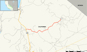
Map of Mono County in eastern California with SR 270 highlighted in red | ||||
| Route information | ||||
| Defined by Streets and Highways Code § 570 | ||||
| Maintained by Caltrans | ||||
| Length: | 9.805 mi[1] (15.780 km) | |||
| Major junctions | ||||
| West end: |
| |||
| East end: | Bodie | |||
| Location | ||||
| Counties: | Mono | |||
| Highway system | ||||
| ||||

State Route 270 (SR 270) is a state highway located in the U.S. state of California in Mono County. It is a spur route off of U.S. Route 395 south of Bridgeport, leading into Bodie State Historic Park.
Route description
The route connects U.S. Route 395 with Bodie State Historic Park. A few miles before entering this park, which holds a preserved ghost town, are unpaved.[2]
Major intersections
Except where prefixed with a letter, postmiles were measured on the road as it was in 1964, based on the alignment that existed at the time, and do not necessarily reflect current mileage. R reflects a realignment in the route since then, M indicates a second realignment, L refers an overlap due to a correction or change, and T indicates postmiles classified as temporary (for a full list of prefixes, see the list of postmile definitions).[1] Segments that remain unconstructed or have been relinquished to local control may be omitted. The entire route is in Mono County.
| Location | Postmile [1][3][4] | Destinations | Notes | ||
|---|---|---|---|---|---|
| | 0.00 | West end of SR 270 | |||
| Bodie | 9.81 | Bodie State Historic Park | East end of SR 270 | ||
| 1.000 mi = 1.609 km; 1.000 km = 0.621 mi | |||||
References
- 1 2 3 California Department of Transportation. "State Truck Route List". Sacramento: California Department of Transportation. Archived from the original (XLS file) on June 30, 2015. Retrieved June 30, 2015.
- ↑ California @ AARoads - California 270
- ↑ California Department of Transportation, Log of Bridges on State Highways, July 2007
- ↑ California Department of Transportation, All Traffic Volumes on CSHS Archived July 21, 2011, at the Wayback Machine., 2006