Cafayate
| Cafayate | |
|---|---|
| Town | |
 Cafayate Location of Cafayate in Argentina | |
| Coordinates: 26°5′S 65°58′W / 26.083°S 65.967°WCoordinates: 26°5′S 65°58′W / 26.083°S 65.967°W | |
| Country |
|
| Province | Salta |
| Department | Cafayate |
| Elevation | 1,683 m (5,522 ft) |
| Population | |
| • Total | 11,785 |
| Time zone | ART (UTC-3) |
| CPA base | A4427 |
| Dialing code | +54 3868 |
| Climate | BWk |
Cafayate (Spanish pronunciation: [kafaˈʒate]) is a town located at the central zone of the Valles Calchaquíes in the province of Salta, Argentina. It sits 1,683 metres (5,522 ft) above mean sea level, at a distance of 189 kilometres (117 mi) from Salta City and 1,329 kilometres (826 mi) from Buenos Aires. It has about 12,000 inhabitants (2001 census [INDEC]).
The town is an important tourist centre for exploring the Calchaquíes valleys, and because of the quality and originality of the wines produced in the area. The largest golf course in South America, at 240 acres (0.97 km2), is currently being developed just outside the city center at La Estancia de Cafayate.[1] The town was founded in 1840 by Manuel Fernando de Aramburu, at the site of a mission. In 1863 the Cafayate Department was created, of which Cafayate is the capital.
Etymology
The Cafayates were a tribe of the Diaguita-Calchaquí group, which, together with the related Tolombón, inhabited the Valles Calchaquíes prior to the arrival of the Spanish Conquistadores. Their language was known as Cacán. Like other Diaguita tribes, they had recently fallen under the influence of the Incas, after a prolonged resistance. They later mounted a fierce resistance to the Spaniards.
Even though most agree that the root of Cafayate is Quechua, the meaning of the term is disputed. Some claim it to mean "Box of Water", others to be a deformation of Capac-Yac ("Great Lake") or Capac-Yaco ("Great Chief" or "Wealthy People"). Another Cacán version understands it as "Grave of Sorrows".
Wines
The wine production is most important in the Valles Calchaquíes. The wines produced in the region benefit from the low-humidity mild weather of the valleys that receive an average of less than 250 mm of precipitation per year. The most characteristic type of wine cultivated in the area is torrontés. Most wine-cellars around the town host free guided tours.
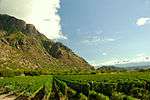 Photo taken from a Winery
 Just 3 blocks from Town
 A sight of a Winery
 Cafayate vineyard
 Vineyard and mountains
 Vinery
Valles Calchaquíes
Many of the most impressive sights in the Valley of the Río las Conchas (Quebrada de Cafayate) are along the paved, 183-kilometres-long National Route 68 that goes from Salta to Cafayate. National Route 40 goes for 165 kilometres from Cafayate to Cachi, another of the most visited points in the area. Other points of interest from Cafayate include Molinos, Tolombón and San Isidro ranch. The town of Cafayate is an attraction by itself, with its laid-back rhythm, colonial style, and wine cellars open to the public.
 The natural Amphitheatre
 People on a Tour
 Desert river
 Las Juntas - Cafayate
 LLama
LLama
References
External links
| Wikimedia Commons has media related to Cafayate. |
- (Spanish) Official site
- Municipal information: Municipal Affairs Federal Institute (IFAM), Municipal Affairs Secretariat, Ministry of Interior, Argentina. (Spanish)
- (Spanish) Salta Tourism
- Tourism
- (Spanish) Description
- (Spanish) Map of the town, and other info
- (Spanish) North of Argentina Tourist info
- (Spanish) Cafayate, Argentina Tourist info