Coogan's Bluff

Coogan's Bluff is a promontory near the western shore of the Harlem River in the Washington Heights neighborhood of Upper Manhattan in New York City. Its boundaries extend approximately from 155th Street to 160th Street, and from Edgecombe Avenue to the river. A deep escarpment descends 175 feet from Edgecombe Avenue to the river, creating a sheltered area between the bluff and river known as Coogan's Hollow. For 83 years, the hollow was home to the legendary Polo Grounds sports stadium.
Namesake
The promontory is named for James J. Coogan (1845–1915), a real estate developer and one-term Manhattan Borough President, who owned the land during the late 19th and early 20th centuries. The earliest known published reference to "Coogan's Bluff" appeared in The New York Times in 1893.[1][2]
Polo Grounds

From 1880 until 1963, the bluff overlooked the Polo Grounds, a professional sports venue that served as home field for Major League Baseball's New York Giants from 1891 until the franchise's move to San Francisco at the end of the 1957 season. Sportwriters commonly used Coogan's Bluff as a sobriquet for the Polo Grounds—as Chavez Ravine now refers to Dodger Stadium and China Basin to AT&T Park— although the ballpark was actually situated in Coogan's Hollow, the bottomland between the bluff and the river.
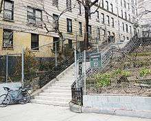
The Bushman Steps, located just west of Coogan's Bluff in Sugar Hill/Hamilton Heights, led from the 155th Street subway station to the Polo Grounds ticket booths; the John T. Brush Stairway, on West 157th Street between St Nicholas Avenue and Edgecombe Avenue, then carried fans the rest of the way down to the stadium.[3] The two stairways are the only intact structures that remain from the Polo Grounds era.[4][5] The Brush Stairway was named in honor of the owner of the Giants franchise from 1890 until his death in 1912. The identity of the Bushman Steps' namesake has apparently been lost.[6]
Housing complex


The 15.15-acre (6.13 ha) hollow, bordered by Frederick Douglass Boulevard, West 155th Street and Harlem River Drive, is currently home to the Polo Grounds Towers housing complex: four 30-story buildings containing a total of 1,616 apartments. The complex was completed on June 30, 1968, and is run by the New York City Housing Authority.[7] Attached to Tower #2 is the Polo Grounds Community Center, run by Children's Village, which hosts such programs as the Polo Grounds Youth Conference.[8] A plaque on the property marks the approximate location of home plate within the demolished ballpark.[9]
Transportation
Coogan's Bluff can be reached via the New York City Subway's 155th Street station, on the IND Concourse Line. City bus routes Bx6, M2, and M10 service the area as well.
Nearby points of interest
The Morris-Jumel Mansion, the oldest house in Manhattan still standing (built in 1765 and now a museum) is located nearby, in Washington Heights.
Immediately across the Harlem River, in the Bronx, is Yankee Stadium, home of Major League Baseball's New York Yankees.
References
- ↑ Pollak, Michael (April 25, 2004). "F.Y.I.". The New York Times. Retrieved 2009-10-25.
- ↑ "The Orange Above the Blue". The New York Times. December 1, 1893. p. 1. Retrieved 2009-10-25.
- ↑
- ↑ "Miller's Homer Beats Phillies". The New York Times. July 9, 1913. p. 8. Retrieved 2009-10-23.
- ↑ Williams, Timothy (February 19, 2008). "A Stairway to Sports History From the Polo Grounds". The New York Times. Retrieved 2009-10-23.
- ↑ NYC Parks Bushman Steps Highlights
- ↑ "Polo Grounds Towers". New York City Housing Authority. Retrieved 2009-10-23.
- ↑ "Polo Ground's Youth Conference" Children's Village. Retrieved 2011-06-01.
- ↑ Spector, Jesse (September 21, 2008). "Yankees had homes before becoming Bronx Bombers". Daily News. New York. Retrieved 2009-10-23.
Coordinates: 40°49′57″N 73°56′21″W / 40.8326°N 73.9393°W