Buharkent
| Buharkent | |
|---|---|
 Buharkent | |
| Coordinates: TR 37°57′42″N 28°44′32″E / 37.96167°N 28.74222°ECoordinates: TR 37°57′42″N 28°44′32″E / 37.96167°N 28.74222°E | |
| Country | Turkey |
| Province | Aydın |
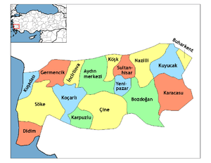
| District | Buharkent |
| Government | |
| • Mayor | Mehmet EROL |
| • Kaymakam | Cemil ÖZTÜRK |
| Area[1] | |
| • District | 101.81 km2 (39.31 sq mi) |
| Population (2012)[2] | |
| • Urban | 6,788 |
| • District | 12,454 |
| • District density | 120/km2 (320/sq mi) |
| Website |
www |
Buharkent is a town and a district of Aydın Province in the Aegean region of Turkey, 86 km east of the city of Aydın, on the road and the railway line to Denizli.
The area is in the valley of the Büyük Menderes River with mountains to the north including the 1724m Karlıkdede. The district is known for its hot springs and geothermal energy, indeed Turkey's first geothermal power station was built here in 1984. However the local economy depends on agriculture especially cotton, figs and grapes.
The name Buharkent means steam city and was given in recognition of the power station, it was previously called Burhaniye.
Buharkent itself is a small town of 6,811 people.
References
- ↑ "Area of regions (including lakes), km²". Regional Statistics Database. Turkish Statistical Institute. 2002. Retrieved 2013-03-05.
- ↑ "Population of province/district centers and towns/villages by districts - 2012". Address Based Population Registration System (ABPRS) Database. Turkish Statistical Institute. Retrieved 2013-02-27.
External links
- the municipality (Turkish)
- BUHARKENT
This article is issued from Wikipedia - version of the 11/10/2016. The text is available under the Creative Commons Attribution/Share Alike but additional terms may apply for the media files.