Buckhart Township, Christian County, Illinois
| Buckhart Township | |
|---|---|
| Township | |
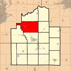 Location in Christian County | |
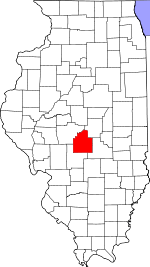 Christian County's location in Illinois | |
| Coordinates: 39°39′44″N 89°20′10″W / 39.66222°N 89.33611°WCoordinates: 39°39′44″N 89°20′10″W / 39.66222°N 89.33611°W | |
| Country |
|
| State |
|
| County | Christian |
| Established | November 7, 1865 |
| Area | |
| • Total | 58.75 sq mi (152.2 km2) |
| • Land | 58.72 sq mi (152.1 km2) |
| • Water | 0.03 sq mi (0.08 km2) 0.05% |
| Elevation | 604 ft (184 m) |
| Population (2010) | |
| • Total | 1,792 |
| • Density | 30.5/sq mi (11.8/km2) |
| Time zone | CST (UTC-6) |
| • Summer (DST) | CDT (UTC-5) |
| ZIP codes | 62513, 62531, 62567, 62568 |
| GNIS feature ID | 0428727 |
Buckhart Township is one of seventeen townships in Christian County, Illinois, USA. As of the 2010 census, its population was 1,792 and it contained 822 housing units.[1]
Geography
According to the 2010 census, the township has a total area of 58.75 square miles (152.2 km2), of which 58.72 square miles (152.1 km2) (or 99.95%) is land and 0.03 square miles (0.078 km2) (or 0.05%) is water.[1]
Cities, towns, villages
Unincorporated towns
- Blueville at 39°39′44″N 89°23′31″W / 39.66227°N 89.392034°W
- Sharpsburg at 39°36′50″N 89°21′04″W / 39.613936°N 89.3512°W
Extinct towns
- Campbellsburg at 39°41′01″N 89°25′13″W / 39.683659°N 89.420368°W
(These towns are listed as "historical" by the USGS.)
Cemeteries
The township contains these four cemeteries: Bethel Baptist, Buckhart Dutch Reform, Edinburg and Goode.
Major highways
School districts
- Edinburg Community Unit School District 4
- Taylorville Community Unit School District 3
Political districts
- State House District 87
- State Senate District 44
References
- "Buckhart Township, Christian County, Illinois". Geographic Names Information System. United States Geological Survey. Retrieved 2010-01-04.
- United States Census Bureau 2009 TIGER/Line Shapefiles
- United States National Atlas
- 1 2 "Population, Housing Units, Area, and Density: 2010 - County -- County Subdivision and Place -- 2010 Census Summary File 1". United States Census. Retrieved 2013-05-28.
External links

Municipalities and communities of Christian County, Illinois, United States | ||
|---|---|---|
| Cities | ||
| Villages | ||
| Townships | ||
| CDP | ||
| Other unincorporated communities | ||
| Footnotes | ‡This populated place also has portions in an adjacent county or counties | |
This article is issued from Wikipedia - version of the 11/10/2016. The text is available under the Creative Commons Attribution/Share Alike but additional terms may apply for the media files.