Brunswick Old Town Historic District
|
Brunswick Old Town Historic District | |
|
Old Brunswick City Hall, designed in 1889 | |
  | |
| Location | Roughly bounded by 1st, Bay, New Bay, H and Cochran Sts., Brunswick, Georgia |
|---|---|
| Coordinates | 31°08′43″N 81°29′29″W / 31.14528°N 81.49139°WCoordinates: 31°08′43″N 81°29′29″W / 31.14528°N 81.49139°W |
| Area | 289 acres (117 ha) |
| Built | 1885 |
| Architectural style | Stick/eastlake, Queen Anne |
| NRHP Reference # | 79000727[1] |
| Added to NRHP | April 26, 1979 |

Brunswick Old Town Historic District is a historic district in Brunswick, Georgia. It was added to the National Register of Historic Places on April 26, 1979 and includes an area bounded by 1st Street, Bay Street, New Bay Street, H Street, and Cochran Street (4th Ave. and G St., according to one source).[2] Brunswick is one of Georgia's two deep-water ports and is the mainland city associated with the Golden Isles of Georgia, at the junction of I-95 and US 82.[3]
The historic district includes the site of the colonial British town of Brunswick, named after the family of King George III of England. Formed in 1771, it retains its original grid plan (as does Savannah, Georgia). The district has 19th century residential and public buildings including the Hazelhurst-Taylor House in Hanover Square, the Mahoney-McGarvey House on Reynolds Street, and the Old Brunswick City Hall. Some of the sidewalks use hexagonal stone tiles.[3]
Photo gallery
 Old Brunswick City Hall detail
 First Methodist Episcopal Church
 Ritz Theatre, originally the Grand Opera House
 Prep building (1909) at Glynn Academy
 Brick house in the Brunswick Old Town Historic District
 House in the Brunswick Old Town Historic District
 Temple Beth Tefilloh
 House in the Brunswick Old Town Historic District
 St. Athanasius Episcopal Church
 Police Department building
 Mahoney-McGarvey House (1891)
 Glynn Academy (1922)
 Glynn Ice Company (1920)
 S. H. Kress & Co. store building, now a Wells Fargo Bank
 Advent Christian Church
 Old Glynn County courthouse (1907)
 The new city hall (1902)
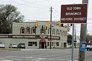 Sign marking the border of Old Town Historic District
 Street sign designating the Old Town Historic Area, the old city hall is in the background
See also
References
- ↑ National Park Service (2010-07-09). "National Register Information System". National Register of Historic Places. National Park Service.
- ↑ Glynn County info on Old Town Historic District Archived October 17, 2015, at the Wayback Machine.
- 1 2 Brunswick Old Town Historic District GEORGIA 14) National Park Service
External links
-
 Media related to Brunswick Old Town Historic District at Wikimedia Commons
 - Media related to Brunswick Historic City Hall at Wikimedia Commons
- Media related to Brunswick City Hall (Georgia) at Wikimedia Commons
- Media related to Glynn County Courthouse at Wikimedia Commons
- Media related to Glynn County former courthouse at Wikimedia Commons
- Media related to Glynn Academy at Wikimedia Commons
- Media related to Ritz Theatre (Brunswick) at Wikimedia Commons
| Topics | |
|---|---|
| Lists by states |
|
| Lists by insular areas | |
| Lists by associated states | |
| Other areas | |
| |