Brothertown, Wisconsin
| Brothertown, Wisconsin | |
|---|---|
| Town | |
 Location of Brothertown, Wisconsin | |
| Coordinates: 43°58′28″N 88°15′4″W / 43.97444°N 88.25111°W | |
| Country | United States |
| State | Wisconsin |
| County | Calumet |
| Area | |
| • Total | 54.5 sq mi (141.2 km2) |
| • Land | 36.6 sq mi (94.8 km2) |
| • Water | 17.9 sq mi (46.4 km2) |
| Elevation[1] | 984 ft (300 m) |
| Population (2010) | |
| • Total | 1,329 |
| • Density | 36/sq mi (14.0/km2) |
| Time zone | Central (CST) (UTC-6) |
| • Summer (DST) | CDT (UTC-5) |
| Area code(s) | 920 |
| FIPS code | 55-10350[2] |
| GNIS feature ID | 1582873[1] |

Brothertown is a town in Calumet County in the U.S. state of Wisconsin. The population was 1,329 at the 2010 census.[3] The unincorporated communities of Brothertown, Charlesburg, Eckers Lakeland, Jericho, and Maple Heights are located in the town. The unincorporated community of Calumetville is also located partially in the town.
History
The town was inhabited by the Brothertown Indians, who moved here from the state of New York from 1831 to 1836. The town was created on March 21, 1843, as "Manchester".[4] It was renamed "Brothertown" on May 4/May 5, 1857.[4]
Geography
The town occupies the southwest corner of Calumet County, with the western 1/3 of the town in Lake Winnebago. The town is bordered by Winnebago County to the west and Fond du Lac County to the south. U.S. Route 151 crosses the west side of the town, passing through the community of Brothertown. According to the United States Census Bureau, the town has a total area of 54.5 square miles (141.2 km2), of which 36.6 square miles (94.8 km2) is land and 17.9 square miles (46.4 km2), or 32.83%, is water.[3]
Demographics
As of the census[2] of 2000, there were 1,404 people, 523 households, and 380 families residing in the town. The population density was 38.2 people per square mile (14.7/km²). There were 627 housing units at an average density of 17.0 per square mile (6.6/km²). The racial makeup of the town was 99.79% White, 0.07% African American, 0.07% Native American, and 0.07% from two or more races. Hispanic or Latino of any race were 0.36% of the population.
There were 523 households out of which 33.3% had children under the age of 18 living with them, 63.3% were married couples living together, 4.2% had a female householder with no husband present, and 27.2% were non-families. 23.1% of all households were made up of individuals and 8.0% had someone living alone who was 65 years of age or older. The average household size was 2.68 and the average family size was 3.19.
In the town the population was spread out with 27.3% under the age of 18, 7.7% from 18 to 24, 29.8% from 25 to 44, 23.7% from 45 to 64, and 11.5% who were 65 years of age or older. The median age was 37 years. For every 100 females there were 109.6 males. For every 100 females age 18 and over, there were 119.1 males.
The median income for a household in the town was $49,861, and the median income for a family was $58,083. Males had a median income of $36,929 versus $25,625 for females. The per capita income for the town was $19,816. About 1.0% of families and 1.6% of the population were below the poverty line, including 1.3% of those under age 18 and 3.9% of those age 65 or over.
Coordinates: 43°58′05″N 88°18′32″W / 43.96806°N 88.30889°W
Government
As of 2008, the town chairman is Jeanold Puetz.[5]
Education
The town lies in the New Holstein/Moraine Park Technical College and Chilton/Fox Valley Technical College school districts.[5]
Media
The official newspaper of the town is the Chilton Times-Journal.[5] Notices are published at the town hall on St. Charles Road, Pete's Fisherman's Inn in Brothertown and outside the former Roman Catholic Church in Charlesburg.[5]
References
- 1 2 "US Board on Geographic Names". United States Geological Survey. 2007-10-25. Retrieved 2008-01-31.
- 1 2 "American FactFinder". United States Census Bureau. Archived from the original on 2013-09-11. Retrieved 2008-01-31.
- 1 2 "Geographic Identifiers: 2010 Demographic Profile Data (G001): Brothertown town, Calumet County, Wisconsin". U.S. Census Bureau, American Factfinder. Retrieved September 9, 2015.
- 1 2 Town of Manchester; Wisconsin Historical Society; Accessed July 24, 2008
- 1 2 3 4 Town of Brothertown - 2008 Newsletter
Municipalities and communities of Calumet County, Wisconsin, United States | ||
|---|---|---|
| Cities | 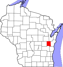 | |
| Villages | ||
| Towns | ||
| CDP | ||
| Unincorporated communities | ||
| Ghost town | ||
| Footnotes | ‡This populated place also has portions in an adjacent county or counties | |