Bridgetown, Mississippi
| Bridgetown, Mississippi | |
|---|---|
| Census-designated place | |
 Bridgetown | |
| Coordinates: 34°53′27″N 89°54′25″W / 34.89083°N 89.90694°WCoordinates: 34°53′27″N 89°54′25″W / 34.89083°N 89.90694°W | |
| Country | United States |
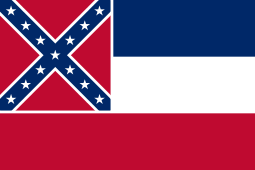
| State | Mississippi |
| County | Desoto |
| Area | |
| • Total | 2.32 sq mi (6.02 km2) |
| • Land | 2.21 sq mi (5.73 km2) |
| • Water | 0.11 sq mi (0.29 km2) |
| Elevation | 371 ft (113 m) |
| Population (2010) | |
| • Total | 1,742 |
| • Density | 787/sq mi (303.9/km2) |
| Time zone | Central (CST) (UTC-6) |
| • Summer (DST) | CDT (UTC-5) |
| ZIP code | 38651 |
| Area code(s) | 662 |
| GNIS feature ID | 2586584[1] |
Bridgetown is am unincorporated community and census-designated place (CDP) in Desoto County, Mississippi, United States. As of the 2010 census, it had a population of 1,742.[2] Bridgetown is approximately 6 miles (10 km) east of Nesbit and 3.5 miles (5.6 km) south-southwest of Pleasant Hill.
References
- ↑ U.S. Geological Survey Geographic Names Information System: Bridgetown, Mississippi
- ↑ "Geographic Identifiers: 2010 Demographic Profile Data (G001): Bridgetown CDP, Mississippi". U.S. Census Bureau, American Factfinder. Retrieved November 2, 2015.
Municipalities and communities of DeSoto County, Mississippi, United States | ||
|---|---|---|
| Cities | 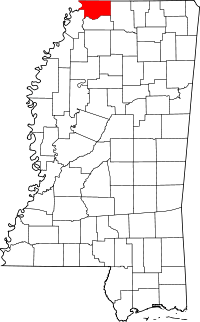 | |
| Town | ||
| CDPs | ||
| Other communities | ||


This article is issued from Wikipedia - version of the 11/2/2015. The text is available under the Creative Commons Attribution/Share Alike but additional terms may apply for the media files.