Bridgeport station (Connecticut)
Bridgeport | |||||||||||||||||||||||||||||||||||||||||
|---|---|---|---|---|---|---|---|---|---|---|---|---|---|---|---|---|---|---|---|---|---|---|---|---|---|---|---|---|---|---|---|---|---|---|---|---|---|---|---|---|---|
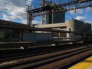 The westbound platform | |||||||||||||||||||||||||||||||||||||||||
| Location |
525 Water Street, Bridgeport, CT 06604 United States | ||||||||||||||||||||||||||||||||||||||||
| Coordinates | 41°10′40″N 73°11′14″W / 41.1778°N 73.1871°WCoordinates: 41°10′40″N 73°11′14″W / 41.1778°N 73.1871°W | ||||||||||||||||||||||||||||||||||||||||
| Line(s) | Northeast Corridor (ConnDOT) | ||||||||||||||||||||||||||||||||||||||||
| Platforms | 2 side platforms | ||||||||||||||||||||||||||||||||||||||||
| Tracks | 4 | ||||||||||||||||||||||||||||||||||||||||
| Connections |
| ||||||||||||||||||||||||||||||||||||||||
| Construction | |||||||||||||||||||||||||||||||||||||||||
| Disabled access | Yes | ||||||||||||||||||||||||||||||||||||||||
| Other information | |||||||||||||||||||||||||||||||||||||||||
| Station code | BRP (Amtrak) | ||||||||||||||||||||||||||||||||||||||||
| Fare zone | 19 (Metro-North) | ||||||||||||||||||||||||||||||||||||||||
| History | |||||||||||||||||||||||||||||||||||||||||
| Opened | 1840[1] | ||||||||||||||||||||||||||||||||||||||||
| Rebuilt | 1975 | ||||||||||||||||||||||||||||||||||||||||
| Electrified | 12,500V (AC) overhead catenary | ||||||||||||||||||||||||||||||||||||||||
| Traffic | |||||||||||||||||||||||||||||||||||||||||
| Passengers (2015) |
80,199[2] | ||||||||||||||||||||||||||||||||||||||||
| Services | |||||||||||||||||||||||||||||||||||||||||
| |||||||||||||||||||||||||||||||||||||||||
Bridgeport is a shared Metro-North Railroad, Shore Line East, and Amtrak train station along the Northeast Corridor that serves Bridgeport, Connecticut and nearby towns. On the Metro-North, the station is the transfer point between the Waterbury Branch and the New Haven mainline. Besides Metro-North service, Amtrak's Northeast Regional and Vermonter stop at the station, as do Shore Line East trains.[3] In addition the transfer point for Greater Bridgeport Transit Authority buses, the departure point for the Bridgeport & Port Jefferson Ferry across Long Island Sound to Port Jefferson, New York, and both the Arena at Harbor Yard and the Ballpark at Harbor Yard are located adjacent to the station.
It is 55.4 miles (89.2 km) from Grand Central Terminal and the average travel time is one hour, 21 minutes.
Opened in 1975, the current station was designed by the local architectural firm of Antinozzi Associates.[1] Unusually, the station spans the six lanes of Water Street, with the passenger waiting room located over the roadway. The simple concrete facades are scored with vertical lines or channels to create a textured surface. Throughout the day, as the sun rakes across the walls, the channels—of varying depth and width—produce a range of ever-changing shadows. Boxy in appearance and punctuated by rectangular windows, the station’s angularity is softened by the rounded edges of the access towers.[1]
Platform and track configuration
| 3 | ■ New Haven Line | for Grand Central |
| ■ Northeast Corridor | for New York and Washington, D.C. | |
| 1 | ■ New Haven Line | no stop |
| ■ Northeast Corridor | no stop | |
| 2 | ■ New Haven Line | no stop |
| ■ Northeast Corridor | no stop | |
| 4 | ■ New Haven Line | for New Haven – State Street and Waterbury |
| ■ Northeast Corridor | for St. Albans and Boston |
This station has two high-level side platforms, each eight cars long. The western platform, adjacent to Track 3, is generally used by westbound Metro-North trains or southbound Amtrak trains. The eastern platform, adjacent to Track 4, is generally used by eastbound Metro-North trains or northbound Amtrak trains. Waterbury Branch trains use either platform.
The New Haven Line has four tracks at this location. The two inner tracks, not adjacent to either platform, are used only by express trains.
History


The current station in Bridgeport was fully completed under ConnDOT and Penn Central in 1975. It replaced a large, ornate structure built in 1905, located to the north of the current station at 41°10′52″N 73°11′15″W / 41.181206°N 73.187535°W. The relocation was occasioned by the introduction of "Cosmopolitan" M-2 railcars which could only board at high-level platforms, the installation of which was impractical at the old station due to the curvature of the platforms. The older station was razed in the 1980s.
A branch line, originally built by New Haven Railroad predecessor Housatonic Railroad to Trumbull, Monroe and Newtown, used to join the main tracks at the old Bridgeport station (see tracks at far left on pictures below). All evidence of this junction is now gone, but the related bridges of this line existed near Bridgeport station until the 1990s. Evidence of this line is still visible further north, including a rail bridge crossing the Merritt Parkway near the Route 25 exits, and a rail trail that extends from Trumbull to the Newtown - Monroe town line.[4]
Bridgeport Station was also close to the scene of three of Connecticut's worst train accidents. The first occurred on July 11, 1911 about a mile south of the station, near where Fairfield Avenue (CT 130) passes underneath and I-95 currently passes overhead. Fourteen people were killed and 40 injured; excessive speed through a crossover was the cause.[5] The second occurred on July 14, 1955 due to excessive speed on a sharp curve approaching the station; one person was killed and 58 were injured.[6] Both accidents involved the same train, the northbound Federal Express overnight train from Washington, D.C. to Boston. The third wreck, involving the derailment and sideswiping collision of two Metro-North trains, occurred on May 17, 2013, at the same location as the 1911 wreck, injuring 60 passengers on both trains.[7] A track defect was suspected pending completion of an investigation.[8]
Ridership
As of August 2006, average weekday commuter ridership was 3,120 passengers. Bridgeport is the busiest Metro-North station between Stamford and New Haven's Union Station.[9] The station has 1,453 parking spaces, 950 owned by the state.[10]
See also
- Connecticut Rail Commuter Council is the official state advocate for train commuters and brings station problems to the attention of officials.
References
- 1 2 3 Great American Stations. Accessed March 1, 2013.
- ↑ "Amtrak Fact Sheet, FY2015, State of Connecticut" (PDF). Amtrak. November 2015. Retrieved May 1, 2016.
- ↑ There is no Amtrak ticket office at the station, but there are "Quick-Trak" machines accessible during station hours."Amtrak - Stations - Bridgeport, CT (BRP)". Retrieved 2008-07-27.
- ↑ "Regional Bicycle Trail".
- ↑ Belnap, H. W. "Report No. 6: The New York, New Haven and Hartford Railroad in re Accident at Bridgeport, Connecticut, July 11, 1911" (PDF). Interstate Commerce Commission accident reports. U.S. Department of Transportation. Retrieved 16 June 2012.
- ↑ "Report No. 3642: The New York, New Haven and Hartford Railroad in re Accident at Bridgeport, Connecticut, July 14, 1955" (PDF). Interstate Commerce Commission accident reports. U.S. Department of Transportation. Retrieved 16 June 2012.
- ↑ Matt Flegenheimer; Robert Davey (May 18, 2013). "Metro-North Trains Collide in Connecticut; Dozens of Injuries Are Reported". New York Times. Retrieved 23 May 2013.
- ↑ Cassidy, Martin B. (May 24, 2013). "NTSB releases findings into Metro-North derailment". Stamford Advocate. Retrieved 24 May 2013.
- ↑ "http://www.nytimes.com/packages/html/nyregion/commutemetro-north.html". New York Times. Retrieved 2008-08-27. External link in
|title=(help) - ↑ Task 2: Technical Memorandum parking Inventory and Utilization: Final Report" submitted by Urbitran Associates Inc. to the Connecticut Department of Transportation, "Table 1: New Haven Line Parking Capacity and Utilization", page 6, July 2003 Archived July 12, 2007, at the Wayback Machine."
External links
![]() Media related to Bridgeport (Metro-North station) at Wikimedia Commons
Media related to Bridgeport (Metro-North station) at Wikimedia Commons
- Amtrak – Stations – Bridgeport, CT
- List of upcoming Metro-North train arrival and departure times and track assignments from MTA
- Bridgeport Amtrak Station (USA Rail Guide -- Train Web)
- Water Street entrance from Google Maps Street View
- Bridgeport (BRP)--Great American Stations (Amtrak)