Breiðafjörður
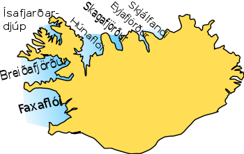
Breiðafjörður is a large shallow bay, about 50 km wide and 125 km long, in the west of Iceland. It separates the region of the Westfjords (Vestfirðir) from the south of the country. Breiðafjörður is encircled by mountains, including the glacier Snæfellsjökull on the Snæfellsnes peninsula to the south and the West Fjord peninsula to the north. An interesting feature of the bay is that the northern tip was formed about 15 million years ago, whereas the southern end at Snæfellsnes was formed less than half that time ago.
Nature

Breiðafjörður has a spectacular land and seascape consisting of shallow seas, small fjords and bays and an inner part of intertidal areas dotted with about 3,000 islands, islets and skerries. The area contains about half of Iceland's intertidal area and tides can be six metres. The bedrock was formed during rift volcanism in the late Tertiary. The area consists mainly of pile of basaltic lava that was deeply eroded by glaciers during the quaternary age thus creating diverse landscape with several geothermal sites, some visible only at low tide.
Plants and animals
The big intertidal zone is high in biodiversity and productivity and has extensive algal forests and other important habitats for fish and invertebrates. The area supports 230 species of vascular plants and around 50 breeding bird species including common shag, glaucous gull, white-tailed eagle, common eider, black guillemot and grey phalarope. The area is important staging area for brent goose and red knot. The common seal and the grey seal have their main haul-out on the islands and skerries.
Several species of cetaceans are commonly found including common porpoise, white-beaked dolphin, killer whale and minke whale.
Islands

_Iceland_M74A1908.jpg)
The islands in Breiðafjörður have an unbroken history of human use but now only few islands are inhabited year-round. Many islands are used for summer residences and natural resources such as eiderdown harvesting is the main source of income for many farmers. Some of the islands are:
Economy and Ecology
Fisheries, tourism and algal harvesting are other major uses of the area.
Breiðafjörður is the spawning ground for some of Iceland's most important economic fish species.
Transport

If the weather is fine, it is possible to see the coast line of the West Fjords from the Snæfellsnes peninsula, but in reality they lie at a distance of up to 40 km. From the little port of Stykkishólmur, there is a ferry to the West Fjords. But people can also travel overland by car, taking the road from the east of Snæfellsnes along the Hvammsfjörður, the narrowest part of the Breiðafjörður.
Culture and history

In the fjord, a big number of islands are situated which were inhabited in former times, on and off for several hundred years. The most important of these islands is Flatey. In the summertime, it can be reached by ferry. During the Middle Ages, especially in the 12th century, there was a monastery of Augustine monks which represented a centre of Icelandic culture. The most extensive medieval manuscript, the Flateyjarbók was written there. Afterwards, the island was an important trading post.
See also: Fjords of Iceland
External links
| Wikimedia Commons has media related to Breiðafjörður. |
Coordinates: 65°15′N 23°15′W / 65.250°N 23.250°W