Brazeau River
| Brazeau River | |
|---|---|
|
The Brazeau River in Banff National Park | |
| Country |
|
| Basin | |
| Main source |
Cataract Pass 2,240 m (7,350 ft) 52°13′57″N 117°03′38″W / 52.23250°N 117.06056°W |
| River mouth |
North Saskatchewan River 820 m (2,690 ft) 52°55′03″N 115°13′45″W / 52.91750°N 115.22917°WCoordinates: 52°55′03″N 115°13′45″W / 52.91750°N 115.22917°W |
| Physical characteristics | |
| Length | 210 km (130 mi) |

The Brazeau River is a river in western Alberta, Canada. It is a major tributary of the North Saskatchewan River.
The river was named for Joseph Brazeau, a linguist associated with the Palliser Expedition.[1]
Course
The river originates in the heights of the Canadian Rockies from the Brazeau Lake (which is fed by creeks that flow from the Coronet Glacier and Queen Elisabeth Ranges) and flows east through the Rocky Mountains foothills until it merges into the North Saskatchewan River between Drayton Valley and Rocky Mountain House at Brazeau Forks.
The upper course runs eastwards from Jasper National Park into the Brazeau Canyon Wildland park. The O'Chiese Indian Reserve is established at the confluence with Nordegg River.
The total length of the river is 210 kilometres (130 mi). The river, and various other local geographic features, were named after Joseph Brazeau, a Missouri-born fur trader working for the Hudson's Bay Company in the area between 1852–64.[2]
Hydroelectric development
The Brazeau River has long been seen as a potential site for hydroelectric power generation. The earliest scheme to harness the power of the river was hatched in 1913 and involved a dam and storage on Brazeau Lake. The potential power generation was estimated at 5,000 to 10,000 kVA, and power would have been transmitted to Edmonton and Calgary, both roughly 400 kilometres (250 mi) from the generator (this was a relatively ambitious plan: long-distance transmission was not common at the time). The plan was scuttled after the discovery of a large underflow at Brazeau Lake, precluding its use as a storage facility.[3]
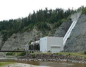
The 99 square kilometres (38 sq mi) Brazeau Reservoir was created on the lower course through the construction of the Brazeau Dam. Its hydroelectric power plant is Alberta's largest with a capacity of 355 MW and an annual production of about 394,000 MW·h of electrical energy.[1]
An unusual feature of this hydroelectric development commissioned in 1965 is a pump system capable of lifting water from the reservoir into the 20-kilometre (12 mi) long canal leading to the power plant so that it can operate at low reservoir water levels.
Tributaries

- Boulder Creek
- Four Point Creek
- Brazeau Lake
- John-John Creek
- Upper Longview Lake
- Job Creek
- Whisker Creek, Whisker Lakes, Job Lake, Leah Lake, Samson Lake
- Isaac Creek
- Race Creek

- Southesk River
- Southesk Lake
- Thistle Creek
- Chimney Creek
- Marshybank Creek
- Marshybank Lake
- Canyon Creek
- Moosehound Creek
- Cardinal River
- Blackstone River
- Elk River
- Nordegg River
See also
References
- 1 2 TransAlta. "Brazeau". Archived from the original on 2008-02-24. Retrieved 2008-03-05.
- ↑ Aphrodite Karamitsanis,Place Names of Alberta, Volume 1. (Calgary: University of Calgary Press, 1991), pg. 30
- ↑ C. H. Attwood, Proposed Hydro-electric Development Scheme on the Brazeau River, (Ottawa: Water Power Branch, 1915).